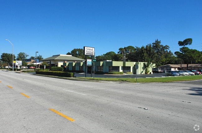
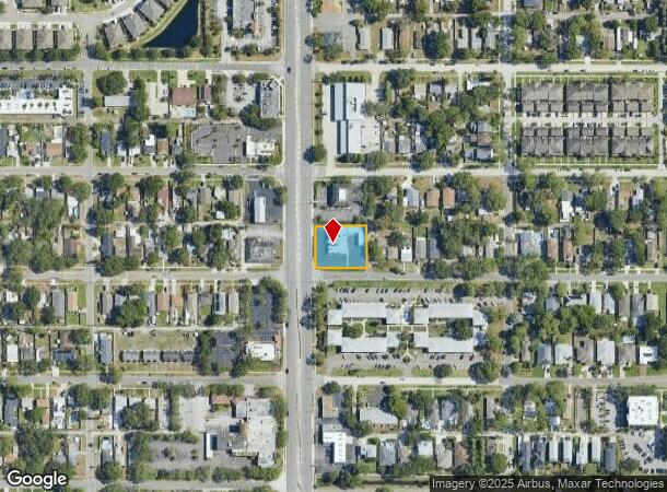
Property Record
4801 4Th St N, Saint Petersburg, FL 33703

NEARBY LISTINGS FOR SALE OR LEASE
Property Detail
4801 4Th St N
Tampa-St. Petersburg-Clearwater, FL
Penns Sub
06-31-17-68328-000-0040
PENNS SUB LOTS 4,5 AND 6 & VAC ALLEY ON E & 7 LESS ST & VAC ALLEY ON N
Officebuilding
Pinellas
AE
Florida
12103C0209H
4,5,6
2024
0.50 AC
2025
South Pinellas
024100
Tampa/St Petersburg
6,066 SF
DEMOGRAPHICS near 4801 4Th St N
1 Mile
3 Mile
5 Mile
2024 Total Population
16,100
102,893
223,689
2029 Population
16,231
103,082
224,355
Pop Growth 2024-2029
+ 0.81%
+ 0.18%
+ 0.30%
Average Age
45
44
43
2024 Total Households
7,816
48,467
104,848
HH Growth 2024-2029
+ 0.60%
+ 0.09%
+ 0.15%
Median Household Inc
$75,679
$65,682
$61,487
Avg Household Size
2.00
2.00
2.00
2024 Avg HH Vehicles
2.00
2.00
2.00
Median Home Value
$301,815
$319,884
$265,134
Median Year Built
1968
1965
1969
Nearby Places
Map Layers
Map Styles
 Street
 Aerial
- Restaurants
- Banks
- Shops
- Fitness
- Groceries
PUBLIC TRANSPORTATION
AIRPORT
St Pete-Clearwater International
DRIVE
WALK
Distance
St Pete-Clearwater International
20 min
9.0 mi
Tampa International
DRIVE
WALK
Distance
Tampa International
27 min
16.8 mi
Sarasota/Bradenton International
DRIVE
WALK
Distance
Sarasota/Bradenton International
53 min
36.4 mi
Freight Ports
Port Manatee
DRIVE
WALK
Distance
Port Manatee
39 min
28.9 mi
Nearby Properties
Address
Land Use
TOTAL SIZE
Lot Size
Zoning
Address
Land Use
TOTAL SIZE
Lot Size
Zoning
12,611 SF
2,367.54 AC
Address
Land Use
TOTAL SIZE
Lot Size
Zoning
807,604 SF
9.61 AC
Address
Land Use
TOTAL SIZE
Lot Size
Zoning
399,617 SF
13.08 AC
Address
Land Use
TOTAL SIZE
Lot Size
Zoning
474,605 SF
1.84 AC
Address
Land Use
TOTAL SIZE
Lot Size
Zoning
242,915 SF
2.20 AC
Address
Land Use
TOTAL SIZE
Lot Size
Zoning
359,527 SF
19.65 AC
Address
Land Use
TOTAL SIZE
Lot Size
Zoning
324,579 SF
16.97 AC
Address
Land Use
TOTAL SIZE
Lot Size
Zoning
309,526 SF
36.85 AC
C2
Address
Land Use
TOTAL SIZE
Lot Size
Zoning
265,688 SF
27.52 AC
Address
Land Use
TOTAL SIZE
Lot Size
Zoning
94,875 SF
0.60 AC
Address
Land Use
TOTAL SIZE
Lot Size
Zoning
68,622 SF
4.24 AC
Address
Land Use
TOTAL SIZE
Lot Size
Zoning
25,465 SF
661.42 AC
Address
Land Use
TOTAL SIZE
Lot Size
Zoning
444,770 SF
14.95 AC
Address
Land Use
TOTAL SIZE
Lot Size
Zoning
464,493 SF
17.41 AC
Address
Land Use
TOTAL SIZE
Lot Size
Zoning
154,178 SF
2.66 AC
Address
Land Use
TOTAL SIZE
Lot Size
Zoning
289,940 SF
12.10 AC
Address
Land Use
TOTAL SIZE
Lot Size
Zoning
111,757 SF
16.04 AC
Address
Land Use
TOTAL SIZE
Lot Size
Zoning
279,586 SF
0.91 AC
Address
Land Use
TOTAL SIZE
Lot Size
Zoning
100,904 SF
8.54 AC
Address
Land Use
TOTAL SIZE
Lot Size
Zoning
261,995 SF
17.08 AC
Address
Land Use
TOTAL SIZE
Lot Size
Zoning
170,146 SF
17.78 AC
Address
Land Use
TOTAL SIZE
Lot Size
Zoning
106,573 SF
2.69 AC
Address
Land Use
TOTAL SIZE
Lot Size
Zoning
174,864 SF
0.91 AC
Address
Land Use
TOTAL SIZE
Lot Size
Zoning
18,758 SF
224 AC
Address
Land Use
TOTAL SIZE
Lot Size
Zoning
110,494 SF
0.77 AC
Address
Land Use
TOTAL SIZE
Lot Size
Zoning
316,421 SF
1.76 AC
Address
Land Use
TOTAL SIZE
Lot Size
Zoning
244,896 SF
28.70 AC
Address
Land Use
TOTAL SIZE
Lot Size
Zoning
3,140 SF
3.37 AC
Address
Land Use
TOTAL SIZE
Lot Size
Zoning
99,116 SF
20.60 AC
Address
Land Use
TOTAL SIZE
Lot Size
Zoning
88,793 SF
13.78 AC
IL
The World's #1 Commercial Real Estate Marketplace
Connect with us
© 2025 CoStar Group
The information above has been obtained from sources believed reliable. While we do not doubt its accuracy we have not verified it and make no guarantee, warranty or representation about it. It is your responsibility to independently confirm its accuracy and completeness. Any projections, opinions, assumptions, or estimates used are for example only and do not represent the current or future performance of the property. The value of this transaction to you depends on tax and other factors which should be evaluated by your tax, financial, and legal advisors. You and your advisors should conduct a careful, independent investigation of the property to determine to your satisfaction the suitability of the property for your needs.