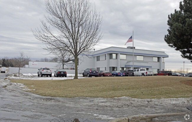
Property Record
4801 68Th Ave, Kenosha, WI 53144


Save to a Folder
{{folder.Name}}
{{folder.ListingIds.length}} Properties
{{folder.ListingIds.length}} Property
Create a New Folder
Property Detail
4801 68Th Ave
08-222-34-202-006
PT NE 1/4 OF NW 1/4 SEC 34 T 2 R 22 COM SE 1/4 COR OF NE 1/4 SEC 34 TH W ALONG S LN SD 1/4 1/4 SEC 325.53 FT TO POB TH CONT W
Commercialnec
Kenosha
M1
Wisconsin
B and X Area of moderate flood hazard, usually the area between the limits of the 100-year and 500-year floods.
6
2025
6.67 AC
2025
Kenosha East
000601
Chicago
30,280 SF
Kenosha, WI
NEARBY LISTINGS FOR SALE OR LEASE
DEMOGRAPHICS near 4801 68Th Ave
1 mile
3 mile
5 mile
2025 Total Population
3,286
59,883
116,925
2030 Population
3,268
59,254
116,089
Pop Growth 2025-2030
(0.55%)
(1.05%)
(0.71%)
Average Age
39
39
40
2025 Total Households
1,241
22,958
46,448
HH Growth 2025-2030
(0.56%)
(1.07%)
(0.71%)
Median Household Inc
$62,009
$72,218
$70,035
Avg Household Size
2.40
2.50
2.40
2025 Avg HH Vehicles
2.00
2.00
2.00
Median Home Value
$249,342
$234,325
$246,626
Median Year Built
1988
1972
1972
Nearby Places
Map Layers
Map Styles
 Street
 Aerial
Layers
 Traffic
 Biking
Places
Listings with unknown addresses are not visible on the map
- Restaurants
- Banks
- Shops
- Fitness
- Groceries
PUBLIC TRANSPORTATION
COMMUTER RAIL
Kenosha Station (Union Pacific North Line - Northeast Illinois Regional Commuter Railroad (Metra))
Drive
Walk
Distance
Kenosha Station (Union Pacific North Line - Northeast Illinois Regional Commuter Railroad (Metra))
10 min
3.9 mi
AIRPORT
General Mitchell International
Drive
Walk
Distance
General Mitchell International
38 min
30.0 mi
Freight Ports
Port Milwaukee
Drive
Walk
Distance
Port Milwaukee
43 min
33.9 mi
Nearby Properties
Address
Land Use
TOTAL SIZE
Lot Size
Zoning
Address
Land Use
TOTAL SIZE
Lot Size
Zoning
731,186 SF
81.94 AC
M2
Address
Land Use
TOTAL SIZE
Lot Size
Zoning
481,854 SF
84.10 AC
FW
Address
Land Use
TOTAL SIZE
Lot Size
Zoning
3,886 SF
20.04 AC
Address
Land Use
TOTAL SIZE
Lot Size
Zoning
77.22 AC
M2
Address
Land Use
TOTAL SIZE
Lot Size
Zoning
850,230 SF
39.46 AC
M2
Address
Land Use
TOTAL SIZE
Lot Size
Zoning
763,999 SF
57.67 AC
FW
Address
Land Use
TOTAL SIZE
Lot Size
Zoning
626,520 SF
35.19 AC
M2
Address
Land Use
TOTAL SIZE
Lot Size
Zoning
602,348 SF
36.02 AC
Address
Land Use
TOTAL SIZE
Lot Size
Zoning
601,439 SF
32.10 AC
Address
Land Use
TOTAL SIZE
Lot Size
Zoning
35,092 SF
26.34 AC
B2
Address
Land Use
TOTAL SIZE
Lot Size
Zoning
3,721 SF
24.57 AC
FW
Address
Land Use
TOTAL SIZE
Lot Size
Zoning
26,016 SF
14.02 AC
FW
Address
Land Use
TOTAL SIZE
Lot Size
Zoning
451,022 SF
30.04 AC
Address
Land Use
TOTAL SIZE
Lot Size
Zoning
32,526 SF
47.82 AC
Address
Land Use
TOTAL SIZE
Lot Size
Zoning
205,894 SF
31.07 AC
M2
Address
Land Use
TOTAL SIZE
Lot Size
Zoning
52,016 SF
25.40 AC
FW
Address
Land Use
TOTAL SIZE
Lot Size
Zoning
194,281 SF
19.13 AC
B2
Address
Land Use
TOTAL SIZE
Lot Size
Zoning
85,847 SF
5.03 AC
RM2
Address
Land Use
TOTAL SIZE
Lot Size
Zoning
50,145 SF
12.76 AC
Address
Land Use
TOTAL SIZE
Lot Size
Zoning
4,643 SF
60 AC
Address
Land Use
TOTAL SIZE
Lot Size
Zoning
109,526 SF
6.61 AC
M2
Address
Land Use
TOTAL SIZE
Lot Size
Zoning
32,245 SF
22 AC
RM2
Address
Land Use
TOTAL SIZE
Lot Size
Zoning
20.33 AC
M2
Address
Land Use
TOTAL SIZE
Lot Size
Zoning
250,185 SF
14.46 AC
M2
Address
Land Use
TOTAL SIZE
Lot Size
Zoning
279,872 SF
14.60 AC
M2
Address
Land Use
TOTAL SIZE
Lot Size
Zoning
26.05 AC
Address
Land Use
TOTAL SIZE
Lot Size
Zoning
48,284 SF
4.99 AC
Address
Land Use
TOTAL SIZE
Lot Size
Zoning
14.40 AC
Address
Land Use
TOTAL SIZE
Lot Size
Zoning
2,963 SF
13.16 AC
Address
Land Use
TOTAL SIZE
Lot Size
Zoning
148,330 SF
17.55 AC
The World's #1 Commercial Real Estate Marketplace
Connect with us
© 2026 CoStar Group
The information above has been obtained from sources believed reliable. While we do not doubt its accuracy we have not verified it and make no guarantee, warranty or representation about it. It is your responsibility to independently confirm its accuracy and completeness. Any projections, opinions, assumptions, or estimates used are for example only and do not represent the current or future performance of the property. The value of this transaction to you depends on tax and other factors which should be evaluated by your tax, financial, and legal advisors. You and your advisors should conduct a careful, independent investigation of the property to determine to your satisfaction the suitability of the property for your needs.