Property Record
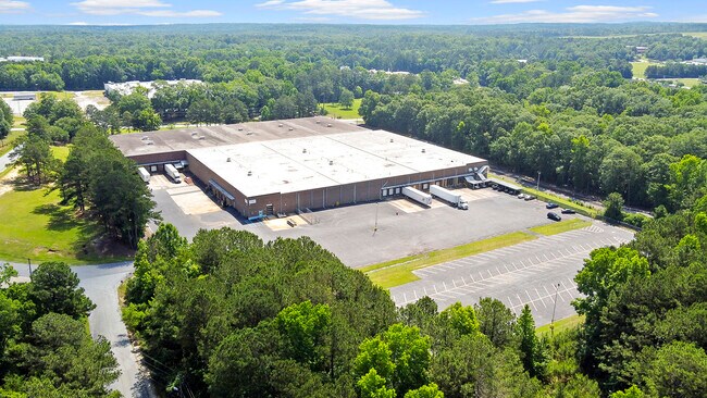
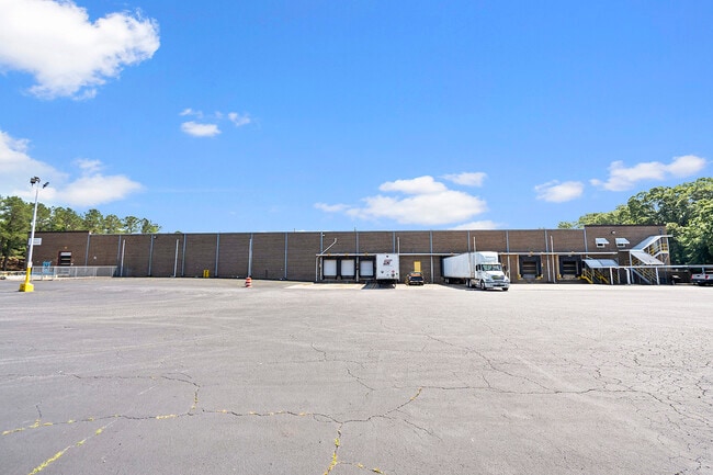
4801 Cargo Dr, Columbus, GA 31907

Property Detail
4801 Cargo Dr
Columbus, GA-AL
TR 4 SURV LT 22 & ADJ LANDS COLS EAST IND PK LEASEHOLD 1
112-002-007
Muscogee
Industrialgeneral
Georgia
B and X Area of moderate flood hazard, usually the area between the limits of the 100-year and 500-year floods.
22
2025
13.45 AC
2025
Greater Columbus
010502
Columbus GA
186,912 SF
NEARBY LISTINGS FOR SALE OR LEASE
-
-
-
No Photo
-
-
-
-
-
View all Columbus listings for lease on LoopNet.com
DEMOGRAPHICS near 4801 Cargo Dr
1 mile
3 mile
5 mile
2025 Total Population
2,643
41,107
94,854
2030 Population
2,570
39,523
91,008
Pop Growth 2025-2030
(2.76%)
(3.85%)
(4.05%)
Average Age
37
38
39
2025 Total Households
1,272
16,960
38,755
HH Growth 2025-2030
(2.44%)
(3.64%)
(3.84%)
Median Household Inc
$48,979
$54,303
$55,669
Avg Household Size
2.10
2.40
2.40
2025 Avg HH Vehicles
1.00
2.00
2.00
Median Home Value
$166,666
$182,224
$195,589
Median Year Built
1986
1983
1980
Nearby Places
Map Layers
Map Styles
 Street
 Aerial
Layers
 Traffic
 Biking
Places
Listings with unknown addresses are not visible on the map
- Restaurants
- Banks
- Shops
- Fitness
- Groceries
PUBLIC TRANSPORTATION
AIRPORT
Columbus
Drive
Walk
Distance
Columbus
13 min
5.6 mi
Freight Ports
Port of Panama City
Drive
Walk
Distance
Port of Panama City
247 min
192.3 mi
SALE & LEASE HISTORY
LISTING DATE
SALE/LEASE

Sep 25, 2016
For Lease
Jun 19, 2024
For Lease
Jul 08, 2021
For Lease
Nearby Properties
Address
Land Use
TOTAL SIZE
Lot Size
Zoning
Address
Land Use
TOTAL SIZE
Lot Size
Zoning
Address
Land Use
TOTAL SIZE
Lot Size
Zoning
194,649 SF
68.60 AC
Address
Land Use
TOTAL SIZE
Lot Size
Zoning
1,763.42 AC
Address
Land Use
TOTAL SIZE
Lot Size
Zoning
81,780 SF
40 AC
Address
Land Use
TOTAL SIZE
Lot Size
Zoning
Address
Land Use
TOTAL SIZE
Lot Size
Zoning
Address
Land Use
TOTAL SIZE
Lot Size
Zoning
6,005 SF
28.62 AC
Address
Land Use
TOTAL SIZE
Lot Size
Zoning
210,532 SF
57.21 AC
Address
Land Use
TOTAL SIZE
Lot Size
Zoning
64,804 SF
52.07 AC
Address
Land Use
TOTAL SIZE
Lot Size
Zoning
5,963 SF
23.90 AC
Address
Land Use
TOTAL SIZE
Lot Size
Zoning
6,032 SF
50.72 AC
Address
Land Use
TOTAL SIZE
Lot Size
Zoning
6,162 SF
58.29 AC
Address
Land Use
TOTAL SIZE
Lot Size
Zoning
Address
Land Use
TOTAL SIZE
Lot Size
Zoning
Address
Land Use
TOTAL SIZE
Lot Size
Zoning
413,817 SF
102.42 AC
Address
Land Use
TOTAL SIZE
Lot Size
Zoning
33.30 AC
Address
Land Use
TOTAL SIZE
Lot Size
Zoning
4,360 SF
25.18 AC
Address
Land Use
TOTAL SIZE
Lot Size
Zoning
8,829 SF
28.49 AC
Address
Land Use
TOTAL SIZE
Lot Size
Zoning
360 SF
106.65 AC
Address
Land Use
TOTAL SIZE
Lot Size
Zoning
Address
Land Use
TOTAL SIZE
Lot Size
Zoning
25.08 AC
Address
Land Use
TOTAL SIZE
Lot Size
Zoning
6,324 SF
26.40 AC
Address
Land Use
TOTAL SIZE
Lot Size
Zoning
5,766 SF
19.67 AC
Address
Land Use
TOTAL SIZE
Lot Size
Zoning
1,887 SF
10.37 AC
Address
Land Use
TOTAL SIZE
Lot Size
Zoning
Address
Land Use
TOTAL SIZE
Lot Size
Zoning
200,045 SF
21.11 AC
Address
Land Use
TOTAL SIZE
Lot Size
Zoning
6,254 SF
13.04 AC
Address
Land Use
TOTAL SIZE
Lot Size
Zoning
48,415 SF
9.53 AC
Address
Land Use
TOTAL SIZE
Lot Size
Zoning
185.11 AC
Address
Land Use
TOTAL SIZE
Lot Size
Zoning
5,650 SF
36.52 AC
The World's #1 Commercial Real Estate Marketplace
Connect with us
© 2026 CoStar Group
The information above has been obtained from sources believed reliable. While we do not doubt its accuracy we have not verified it and make no guarantee, warranty or representation about it. It is your responsibility to independently confirm its accuracy and completeness. Any projections, opinions, assumptions, or estimates used are for example only and do not represent the current or future performance of the property. The value of this transaction to you depends on tax and other factors which should be evaluated by your tax, financial, and legal advisors. You and your advisors should conduct a careful, independent investigation of the property to determine to your satisfaction the suitability of the property for your needs.