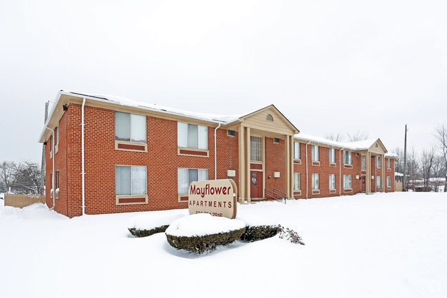
Property Record
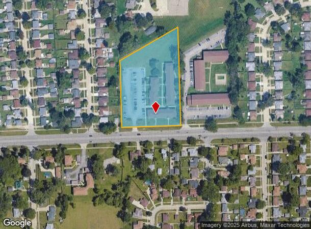
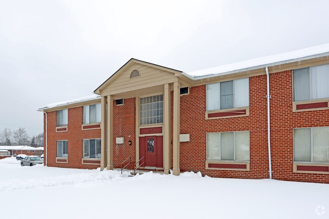
4801 E 10 Mile Rd, Warren, MI 48091
NEARBY LISTINGS FOR SALE OR LEASE
Property Detail
4801 E 10 Mile Rd
12-13-20-379-004
Bear Creek
Multifamilydwelling
T1N, R12E, SEC 20; COMM AT S 1/4 POST SEC 20; TH WEST 333.76 FT TO POB; TH WEST 333.75 FT; TH N00*29'10"E443.53 FT; TH
X
Macomb
26163C0125E
Michigan
2025
1.37 AC
2025
Southwest Warren
262500
Detroit
47,520 SF
Detroit-Warren-Dearborn, MI
DEMOGRAPHICS near 4801 E 10 Mile Rd
1 Mile
3 Mile
5 Mile
2024 Total Population
12,128
128,852
341,914
2029 Population
11,980
127,706
340,327
Pop Growth 2024-2029
(1.22%)
(0.89%)
(0.46%)
Average Age
41
39
39
2024 Total Households
4,771
52,477
141,291
HH Growth 2024-2029
(1.24%)
(0.92%)
(0.47%)
Median Household Inc
$53,831
$49,351
$53,552
Avg Household Size
2.50
2.40
2.40
2024 Avg HH Vehicles
2.00
2.00
2.00
Median Home Value
$144,945
$128,368
$147,523
Median Year Built
1963
1958
1958
Nearby Places
Map Layers
Map Styles
 Street
 Aerial
- Restaurants
- Banks
- Shops
- Fitness
- Groceries
PUBLIC TRANSPORTATION
COMMUTER RAIL
Royal Oak Amtrak (Wolverine - Amtrak)
DRIVE
WALK
Distance
Royal Oak Amtrak (Wolverine - Amtrak)
10 min
5.5 mi
AIRPORT
Windsor International
DRIVE
WALK
Distance
Windsor International
42 min
22.3 mi
Detroit Metro Wayne County
DRIVE
WALK
Distance
Detroit Metro Wayne County
47 min
31.9 mi
Freight Ports
Port of Toledo
DRIVE
WALK
Distance
Port of Toledo
93 min
72.9 mi
Nearby Properties
Address
Land Use
TOTAL SIZE
Lot Size
Zoning
Address
Land Use
TOTAL SIZE
Lot Size
Zoning
3,988,890 SF
223.80 AC
M-3
Address
Land Use
TOTAL SIZE
Lot Size
Zoning
1,727,664 SF
167.66 AC
M-3
Address
Land Use
TOTAL SIZE
Lot Size
Zoning
1,107,643 SF
173.73 AC
MZ
Address
Land Use
TOTAL SIZE
Lot Size
Zoning
322,580 SF
Address
Land Use
TOTAL SIZE
Lot Size
Zoning
910,140 SF
47.78 AC
Address
Land Use
TOTAL SIZE
Lot Size
Zoning
419,600 SF
Address
Land Use
TOTAL SIZE
Lot Size
Zoning
649,140 SF
43.98 AC
Address
Land Use
TOTAL SIZE
Lot Size
Zoning
3,327,621 SF
130.89 AC
M-4
Address
Land Use
TOTAL SIZE
Lot Size
Zoning
207,605 SF
20.56 AC
PUD
Address
Land Use
TOTAL SIZE
Lot Size
Zoning
576,924 SF
31.35 AC
Address
Land Use
TOTAL SIZE
Lot Size
Zoning
1,150,792 SF
53.17 AC
AD
Address
Land Use
TOTAL SIZE
Lot Size
Zoning
450,958 SF
Address
Land Use
TOTAL SIZE
Lot Size
Zoning
674,395 SF
33.13 AC
M-3
Address
Land Use
TOTAL SIZE
Lot Size
Zoning
1,784,888 SF
58.32 AC
M-4
Address
Land Use
TOTAL SIZE
Lot Size
Zoning
306,345 SF
Address
Land Use
TOTAL SIZE
Lot Size
Zoning
455,425 SF
Address
Land Use
TOTAL SIZE
Lot Size
Zoning
348,256 SF
46.10 AC
MZ
Address
Land Use
TOTAL SIZE
Lot Size
Zoning
576,924 SF
36.24 AC
Address
Land Use
TOTAL SIZE
Lot Size
Zoning
146,981 SF
4.11 AC
Address
Land Use
TOTAL SIZE
Lot Size
Zoning
401,671 SF
19.40 AC
MZ
Address
Land Use
TOTAL SIZE
Lot Size
Zoning
207,605 SF
19.39 AC
RETAIL5KSF
Address
Land Use
TOTAL SIZE
Lot Size
Zoning
198,064 SF
11.11 AC
MZ
Address
Land Use
TOTAL SIZE
Lot Size
Zoning
1,261,658 SF
71.94 AC
M-2
Address
Land Use
TOTAL SIZE
Lot Size
Zoning
233,900 SF
15.56 AC
M-2
Address
Land Use
TOTAL SIZE
Lot Size
Zoning
Address
Land Use
TOTAL SIZE
Lot Size
Zoning
272,046 SF
17.63 AC
M-2
Address
Land Use
TOTAL SIZE
Lot Size
Zoning
362,895 SF
14.85 AC
M-2
Address
Land Use
TOTAL SIZE
Lot Size
Zoning
259,959 SF
27.39 AC
MZ
Address
Land Use
TOTAL SIZE
Lot Size
Zoning
442,148 SF
11.22 AC
AD
Address
Land Use
TOTAL SIZE
Lot Size
Zoning
287,360 SF
21.42 AC
AD
The World's #1 Commercial Real Estate Marketplace
Connect with us
© 2026 CoStar Group
The information above has been obtained from sources believed reliable. While we do not doubt its accuracy we have not verified it and make no guarantee, warranty or representation about it. It is your responsibility to independently confirm its accuracy and completeness. Any projections, opinions, assumptions, or estimates used are for example only and do not represent the current or future performance of the property. The value of this transaction to you depends on tax and other factors which should be evaluated by your tax, financial, and legal advisors. You and your advisors should conduct a careful, independent investigation of the property to determine to your satisfaction the suitability of the property for your needs.