Property Record
4801 Feather River Blvd, Oroville, CA 95965
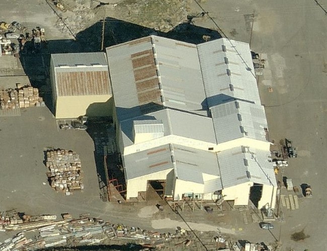

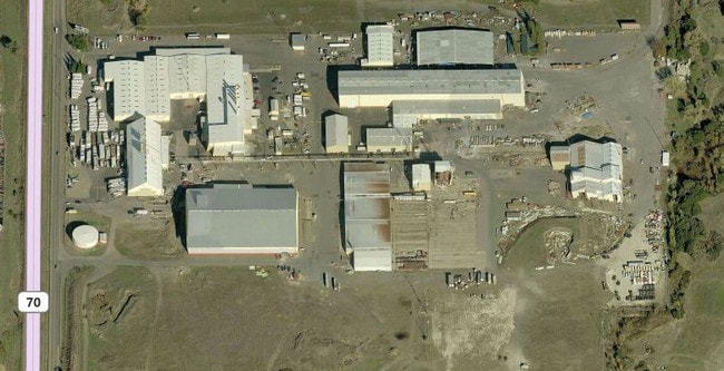
Property Detail
4801 Feather River Blvd
Industrialgeneral
PTN SEC 30 T19N R4E / 4801 FEATHER RIVER BLVD
M2
Butte
C and X Area of minimal flood hazard, usually depicted on FIRMs as above the 500-year flood level.
California
2024
113.69 AC
2025
Other Market Areas
003002
Chico, CA
391,044 SF
035-470-006-000
NEARBY LISTINGS FOR SALE OR LEASE
DEMOGRAPHICS near 4801 Feather River Blvd
1 mile
3 mile
5 mile
2025 Total Population
138
20,365
38,951
2030 Population
137
20,313
38,788
Pop Growth 2025-2030
(0.72%)
(0.26%)
(0.42%)
Average Age
40
38
38
2025 Total Households
57
7,302
13,744
HH Growth 2025-2030
(1.75%)
(0.38%)
(0.51%)
Median Household Inc
$60,469
$47,315
$54,444
Avg Household Size
2.30
2.70
2.70
2025 Avg HH Vehicles
1.00
2.00
2.00
Median Home Value
$195,832
$249,906
$304,543
Median Year Built
1971
1969
1970
Nearby Places
Map Layers
Map Styles
 Street
 Aerial
Layers
 Traffic
 Biking
Places
Listings with unknown addresses are not visible on the map
- Restaurants
- Banks
- Shops
- Fitness
- Groceries
SALE & LEASE HISTORY
LISTING DATE
SALE/LEASE

Sep 25, 2016
For Lease
Nearby Properties
Address
Land Use
TOTAL SIZE
Lot Size
Zoning
Address
Land Use
TOTAL SIZE
Lot Size
Zoning
14.25 AC
C1
Address
Land Use
TOTAL SIZE
Lot Size
Zoning
17.29 AC
Address
Land Use
TOTAL SIZE
Lot Size
Zoning
182,327 SF
21.17 AC
M2
Address
Land Use
TOTAL SIZE
Lot Size
Zoning
36,746 SF
8.39 AC
Address
Land Use
TOTAL SIZE
Lot Size
Zoning
18,980 SF
7.37 AC
HI
Address
Land Use
TOTAL SIZE
Lot Size
Zoning
95,604 SF
8.90 AC
C2
Address
Land Use
TOTAL SIZE
Lot Size
Zoning
2,463 SF
6.96 AC
RP
Address
Land Use
TOTAL SIZE
Lot Size
Zoning
44,461 SF
8.32 AC
C1
Address
Land Use
TOTAL SIZE
Lot Size
Zoning
58,808 SF
4.54 AC
C1
Address
Land Use
TOTAL SIZE
Lot Size
Zoning
66,651 SF
5.08 AC
MHDR
Address
Land Use
TOTAL SIZE
Lot Size
Zoning
58,254 SF
3.52 AC
Address
Land Use
TOTAL SIZE
Lot Size
Zoning
9,874 SF
5 AC
RP
Address
Land Use
TOTAL SIZE
Lot Size
Zoning
53,941 SF
2.47 AC
C2
Address
Land Use
TOTAL SIZE
Lot Size
Zoning
5,995 SF
4.75 AC
C2
Address
Land Use
TOTAL SIZE
Lot Size
Zoning
48,151 SF
1.85 AC
C2
Address
Land Use
TOTAL SIZE
Lot Size
Zoning
65,172 SF
4.45 AC
PD
Address
Land Use
TOTAL SIZE
Lot Size
Zoning
150,712 SF
7.78 AC
RP
Address
Land Use
TOTAL SIZE
Lot Size
Zoning
126,045 SF
8.87 AC
M2
Address
Land Use
TOTAL SIZE
Lot Size
Zoning
51,999 SF
3.69 AC
CLM
Address
Land Use
TOTAL SIZE
Lot Size
Zoning
36.95 AC
MU-1
Address
Land Use
TOTAL SIZE
Lot Size
Zoning
41,932 SF
3.89 AC
Address
Land Use
TOTAL SIZE
Lot Size
Zoning
1.70 AC
MXC
Address
Land Use
TOTAL SIZE
Lot Size
Zoning
45,618 SF
3.90 AC
RP
Address
Land Use
TOTAL SIZE
Lot Size
Zoning
118,066 SF
17.66 AC
Address
Land Use
TOTAL SIZE
Lot Size
Zoning
3.76 AC
MXC
Address
Land Use
TOTAL SIZE
Lot Size
Zoning
38,070 SF
4.62 AC
SC
Address
Land Use
TOTAL SIZE
Lot Size
Zoning
55,552 SF
1.80 AC
C2
Address
Land Use
TOTAL SIZE
Lot Size
Zoning
34,232 SF
3.81 AC
C2
Address
Land Use
TOTAL SIZE
Lot Size
Zoning
23,729 SF
4.71 AC
C-2
The World's #1 Commercial Real Estate Marketplace
Connect with us
© 2026 CoStar Group
The information above has been obtained from sources believed reliable. While we do not doubt its accuracy we have not verified it and make no guarantee, warranty or representation about it. It is your responsibility to independently confirm its accuracy and completeness. Any projections, opinions, assumptions, or estimates used are for example only and do not represent the current or future performance of the property. The value of this transaction to you depends on tax and other factors which should be evaluated by your tax, financial, and legal advisors. You and your advisors should conduct a careful, independent investigation of the property to determine to your satisfaction the suitability of the property for your needs.