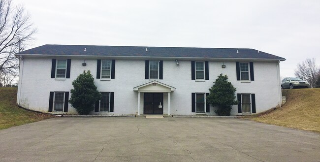
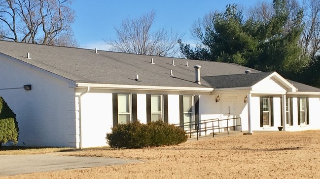
Property Record
4801 Manslick Rd, Louisville, KY 40216

NEARBY LISTINGS FOR SALE OR LEASE
Property Detail
4801 Manslick Rd
067H00190000
Sarah Fenley Division
Specialpurpose
10.226 AC+/- SE COR MANSLICK RD & BLUEGRASS AVE, IRREG LOT
X
Jefferson
21111C0073F
Kentucky
2025
2.83 AC
2025
South Central
012604
Louisville
4,250 SF
Louisville/Jefferson County, KY-IN
DEMOGRAPHICS near 4801 Manslick Rd
1 Mile
3 Mile
5 Mile
2024 Total Population
12,008
102,878
216,737
2029 Population
11,913
101,924
214,917
Pop Growth 2024-2029
(0.79%)
(0.93%)
(0.84%)
Average Age
39
39
38
2024 Total Households
4,770
41,853
89,874
HH Growth 2024-2029
(0.82%)
(1.00%)
(0.88%)
Median Household Inc
$45,597
$44,783
$43,799
Avg Household Size
2.40
2.40
2.30
2024 Avg HH Vehicles
1.00
2.00
2.00
Median Home Value
$149,649
$149,877
$153,600
Median Year Built
1961
1958
1958
Nearby Places
Map Layers
Map Styles
 Street
 Aerial
- Restaurants
- Banks
- Shops
- Fitness
- Groceries
PUBLIC TRANSPORTATION
AIRPORT
Louisville Muhammad Ali International
DRIVE
WALK
Distance
Louisville Muhammad Ali International
11 min
3.8 mi
Freight Ports
Port of Toledo
DRIVE
WALK
Distance
Port of Toledo
362 min
311.1 mi
SALE & LEASE HISTORY
LISTING DATE
SALE/LEASE

May 15, 2017
For Sale
Mar 15, 2019
For Lease
Jan 24, 2018
For Sale
Nearby Properties
Address
Land Use
TOTAL SIZE
Lot Size
Zoning
Address
Land Use
TOTAL SIZE
Lot Size
Zoning
42,228 SF
144.63 AC
R5-RESIDEN
Address
Land Use
TOTAL SIZE
Lot Size
Zoning
Address
Land Use
TOTAL SIZE
Lot Size
Zoning
22,113 SF
19.01 AC
R4-RESIDEN
Address
Land Use
TOTAL SIZE
Lot Size
Zoning
16.31 AC
OR1-OFFICE
Address
Land Use
TOTAL SIZE
Lot Size
Zoning
31.15 AC
EZ1-ENTERP
Address
Land Use
TOTAL SIZE
Lot Size
Zoning
256,872 SF
23.71 AC
C1-COMMERC
Address
Land Use
TOTAL SIZE
Lot Size
Zoning
5,560 SF
Address
Land Use
TOTAL SIZE
Lot Size
Zoning
39,205 SF
15.50 AC
EZ1-ENTERP
Address
Land Use
TOTAL SIZE
Lot Size
Zoning
17,270 SF
4.74 AC
R5-RESIDEN
Address
Land Use
TOTAL SIZE
Lot Size
Zoning
5,568 SF
13.52 AC
C1-COMMERC
Address
Land Use
TOTAL SIZE
Lot Size
Zoning
12.98 AC
EZ1-ENTERP
Address
Land Use
TOTAL SIZE
Lot Size
Zoning
11.68 AC
EZ1-ENTERP
Address
Land Use
TOTAL SIZE
Lot Size
Zoning
285,378 SF
16.79 AC
EZ1-ENTERP
Address
Land Use
TOTAL SIZE
Lot Size
Zoning
308 SF
57.16 AC
EZ1-ENTERP
Address
Land Use
TOTAL SIZE
Lot Size
Zoning
164,677 SF
13.54 AC
EZ1-ENTERP
Address
Land Use
TOTAL SIZE
Lot Size
Zoning
22,160 SF
3.46 AC
EZ1-ENTERP
Address
Land Use
TOTAL SIZE
Lot Size
Zoning
139,200 SF
29.50 AC
EZ1-ENTERP
Address
Land Use
TOTAL SIZE
Lot Size
Zoning
29.54 AC
R5-RESIDEN
Address
Land Use
TOTAL SIZE
Lot Size
Zoning
13,600 SF
14.89 AC
R7-RESIDEN
Address
Land Use
TOTAL SIZE
Lot Size
Zoning
142,900 SF
19.05 AC
EZ1-ENTERP
Address
Land Use
TOTAL SIZE
Lot Size
Zoning
210,121 SF
18.76 AC
EZ1-ENTERP
Address
Land Use
TOTAL SIZE
Lot Size
Zoning
11,136 SF
11.02 AC
R4-RESIDEN
Address
Land Use
TOTAL SIZE
Lot Size
Zoning
117,060 SF
43.17 AC
Address
Land Use
TOTAL SIZE
Lot Size
Zoning
42.68 AC
EZ1-ENTERP
Address
Land Use
TOTAL SIZE
Lot Size
Zoning
136,798 SF
6.31 AC
EZ1-ENTERP
Address
Land Use
TOTAL SIZE
Lot Size
Zoning
2,352 SF
2.42 AC
C2-COMMERC
Address
Land Use
TOTAL SIZE
Lot Size
Zoning
15,928 SF
13.67 AC
R4-RESIDEN
Address
Land Use
TOTAL SIZE
Lot Size
Zoning
24,896 SF
5.47 AC
C1-COMMERC
Address
Land Use
TOTAL SIZE
Lot Size
Zoning
19,375 SF
10.11 AC
C1-COMMERC
The World's #1 Commercial Real Estate Marketplace
Connect with us
© 2026 CoStar Group
The information above has been obtained from sources believed reliable. While we do not doubt its accuracy we have not verified it and make no guarantee, warranty or representation about it. It is your responsibility to independently confirm its accuracy and completeness. Any projections, opinions, assumptions, or estimates used are for example only and do not represent the current or future performance of the property. The value of this transaction to you depends on tax and other factors which should be evaluated by your tax, financial, and legal advisors. You and your advisors should conduct a careful, independent investigation of the property to determine to your satisfaction the suitability of the property for your needs.