Property Record
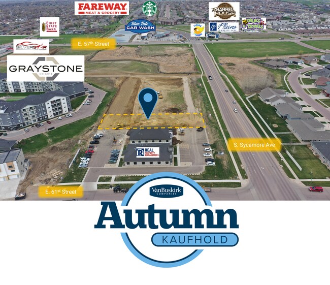
4801 S Sycamore Ave, Sioux Falls, SD 57110


Property Detail
4801 S Sycamore Ave
82097
BLOCK 9 SYCAMORE CROSSING ADDITION TO THE CITY OF SIOUX FALLS
Conveniencestore
MINNEHAHA
B and X Area of moderate flood hazard, usually the area between the limits of the 100-year and 500-year floods.
South Dakota
2024
2.66 AC
2024
Sioux Falls
001805
Other Market Areas
13,783 SF
Sioux Falls, SD-MN
NEARBY LISTINGS FOR SALE OR LEASE
DEMOGRAPHICS near 4801 S Sycamore Ave
1 mile
3 mile
5 mile
2025 Total Population
12,371
57,674
133,584
2030 Population
13,428
62,011
143,232
Pop Growth 2025-2030
+ 8.54%
+ 7.52%
+ 7.22%
Average Age
39
39
39
2025 Total Households
5,099
23,461
54,493
HH Growth 2025-2030
+ 9.16%
+ 8.07%
+ 7.54%
Median Household Inc
$93,277
$80,154
$74,363
Avg Household Size
2.40
2.40
2.40
2025 Avg HH Vehicles
2.00
2.00
2.00
Median Home Value
$392,410
$347,578
$330,304
Median Year Built
2010
1999
1993
Nearby Places
Map Layers
Map Styles
 Street
 Aerial
Transit
 Traffic
 Biking
Places
Listings with unknown addresses are not visible on the map
- Restaurants
- Banks
- Shops
- Fitness
- Groceries
PUBLIC TRANSPORTATION
AIRPORT
Joe Foss Field
Drive
Walk
Distance
Joe Foss Field
30 min
10.1 mi
Freight Ports
Port Milwaukee
Drive
Walk
Distance
Port Milwaukee
551 min
505.1 mi
SALE & LEASE HISTORY
LISTING DATE
SALE/LEASE

May 09, 2023
For Lease
Nearby Properties
Address
Land Use
TOTAL SIZE
Lot Size
Zoning
Address
Land Use
TOTAL SIZE
Lot Size
Zoning
11.33 AC
MUNICIPALI
Address
Land Use
TOTAL SIZE
Lot Size
Zoning
15.39 AC
Address
Land Use
TOTAL SIZE
Lot Size
Zoning
4,358 SF
14.79 AC
Address
Land Use
TOTAL SIZE
Lot Size
Zoning
15.24 AC
MUNICIPALI
Address
Land Use
TOTAL SIZE
Lot Size
Zoning
3,306 SF
17.41 AC
Address
Land Use
TOTAL SIZE
Lot Size
Zoning
94,624 SF
12.31 AC
Address
Land Use
TOTAL SIZE
Lot Size
Zoning
11,800 SF
11.78 AC
Address
Land Use
TOTAL SIZE
Lot Size
Zoning
2,406 SF
13.76 AC
Address
Land Use
TOTAL SIZE
Lot Size
Zoning
8.02 AC
MUNICIPALI
Address
Land Use
TOTAL SIZE
Lot Size
Zoning
92,195 SF
8 AC
Address
Land Use
TOTAL SIZE
Lot Size
Zoning
9.42 AC
MUNICIPALI
Address
Land Use
TOTAL SIZE
Lot Size
Zoning
87,328 SF
6.92 AC
Address
Land Use
TOTAL SIZE
Lot Size
Zoning
7.59 AC
MUNICIPALI
Address
Land Use
TOTAL SIZE
Lot Size
Zoning
5.85 AC
Address
Land Use
TOTAL SIZE
Lot Size
Zoning
10.24 AC
MUNICIPALI
Address
Land Use
TOTAL SIZE
Lot Size
Zoning
8.09 AC
MUNICIPALI
Address
Land Use
TOTAL SIZE
Lot Size
Zoning
9.15 AC
MUNICIPALI
Address
Land Use
TOTAL SIZE
Lot Size
Zoning
9.15 AC
MUNICIPALI
Address
Land Use
TOTAL SIZE
Lot Size
Zoning
7.63 AC
MUNICIPALI
Address
Land Use
TOTAL SIZE
Lot Size
Zoning
4.64 AC
MUNICIPALI
Address
Land Use
TOTAL SIZE
Lot Size
Zoning
5.99 AC
MUNICIPALI
Address
Land Use
TOTAL SIZE
Lot Size
Zoning
6 AC
MUNICIPALI
Address
Land Use
TOTAL SIZE
Lot Size
Zoning
4.40 AC
MUNICIPALI
Address
Land Use
TOTAL SIZE
Lot Size
Zoning
8.28 AC
MUNICIPALI
Address
Land Use
TOTAL SIZE
Lot Size
Zoning
212,260 SF
20.37 AC
Address
Land Use
TOTAL SIZE
Lot Size
Zoning
10.39 AC
MUNICIPALI
Address
Land Use
TOTAL SIZE
Lot Size
Zoning
3.77 AC
MUNICIPALI
Address
Land Use
TOTAL SIZE
Lot Size
Zoning
125,520 SF
5.61 AC
Address
Land Use
TOTAL SIZE
Lot Size
Zoning
58,932 SF
4.93 AC
Address
Land Use
TOTAL SIZE
Lot Size
Zoning
134,519 SF
12 AC
The World's #1 Commercial Real Estate Marketplace
Connect with us
© 2026 CoStar Group
The information above has been obtained from sources believed reliable. While we do not doubt its accuracy we have not verified it and make no guarantee, warranty or representation about it. It is your responsibility to independently confirm its accuracy and completeness. Any projections, opinions, assumptions, or estimates used are for example only and do not represent the current or future performance of the property. The value of this transaction to you depends on tax and other factors which should be evaluated by your tax, financial, and legal advisors. You and your advisors should conduct a careful, independent investigation of the property to determine to your satisfaction the suitability of the property for your needs.