Property Record
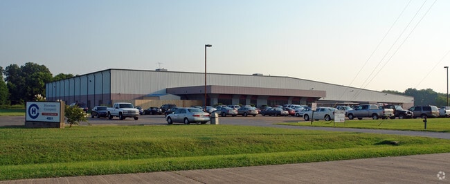
4801 Viking Dr, Bossier City, LA 71111


Property Detail
4801 Viking Dr
129539
COMMENCE AT THE POINT OF INTERSECTION OF THE LINE COMMON TO SECTIONS 13 AND 14 T 18, R 13, AND THE SOUTHERLY R/W LINE OF I-22
Loftbuilding
BOSSIER
AE The base floodplain where base flood elevations are provided. AE Zones are now used on new format FIRMs instead of A1-A30 Zones.
Louisiana
2025
5.88 AC
2025
Bossier Parish
010601
Shreveport/Bossier City
100,000 SF
Shreveport-Bossier City, LA
NEARBY LISTINGS FOR SALE OR LEASE
DEMOGRAPHICS near 4801 Viking Dr
1 mile
3 mile
5 mile
2025 Total Population
3,105
23,114
64,929
2030 Population
3,106
23,220
65,973
Pop Growth 2025-2030
+ 0.03%
+ 0.46%
+ 1.61%
Average Age
39
39
38
2025 Total Households
1,173
9,046
26,081
HH Growth 2025-2030
+ 0.17%
+ 0.52%
+ 1.82%
Median Household Inc
$71,509
$68,051
$62,554
Avg Household Size
2.50
2.50
2.40
2025 Avg HH Vehicles
2.00
2.00
2.00
Median Home Value
$252,272
$236,407
$213,148
Median Year Built
1982
1986
1984
Nearby Places
Map Layers
Map Styles
 Street
 Aerial
Layers
 Traffic
 Biking
Places
Listings with unknown addresses are not visible on the map
- Restaurants
- Banks
- Shops
- Fitness
- Groceries
PUBLIC TRANSPORTATION
AIRPORT
Shreveport Regional
Drive
Walk
Distance
Shreveport Regional
29 min
15.4 mi
Freight Ports
Port of Shreveport
Drive
Walk
Distance
Port of Shreveport
35 min
19.5 mi
Nearby Properties
Address
Land Use
TOTAL SIZE
Lot Size
Zoning
Address
Land Use
TOTAL SIZE
Lot Size
Zoning
1,700 SF
28 AC
Address
Land Use
TOTAL SIZE
Lot Size
Zoning
49,550 SF
65 AC
Address
Land Use
TOTAL SIZE
Lot Size
Zoning
601,879 SF
269 AC
Address
Land Use
TOTAL SIZE
Lot Size
Zoning
66,828 SF
74.46 AC
Address
Land Use
TOTAL SIZE
Lot Size
Zoning
128,389 SF
7.77 AC
Address
Land Use
TOTAL SIZE
Lot Size
Zoning
133,198 SF
54 AC
Address
Land Use
TOTAL SIZE
Lot Size
Zoning
222,616 SF
0.28 AC
Address
Land Use
TOTAL SIZE
Lot Size
Zoning
70,590 SF
28 AC
Address
Land Use
TOTAL SIZE
Lot Size
Zoning
205,616 SF
0.63 AC
Address
Land Use
TOTAL SIZE
Lot Size
Zoning
118,347 SF
13.05 AC
Address
Land Use
TOTAL SIZE
Lot Size
Zoning
110,252 SF
18.86 AC
Address
Land Use
TOTAL SIZE
Lot Size
Zoning
25,413 SF
8 AC
Address
Land Use
TOTAL SIZE
Lot Size
Zoning
74,372 SF
1 AC
Address
Land Use
TOTAL SIZE
Lot Size
Zoning
5,262 SF
16 AC
Address
Land Use
TOTAL SIZE
Lot Size
Zoning
84,000 SF
3 AC
Address
Land Use
TOTAL SIZE
Lot Size
Zoning
255 SF
10 AC
Address
Land Use
TOTAL SIZE
Lot Size
Zoning
76,700 SF
15.47 AC
Address
Land Use
TOTAL SIZE
Lot Size
Zoning
135,238 SF
14.54 AC
Address
Land Use
TOTAL SIZE
Lot Size
Zoning
39,992 SF
5 AC
Address
Land Use
TOTAL SIZE
Lot Size
Zoning
82,547 SF
17 AC
Address
Land Use
TOTAL SIZE
Lot Size
Zoning
133,742 SF
16.62 AC
Address
Land Use
TOTAL SIZE
Lot Size
Zoning
72,696 SF
15 AC
Address
Land Use
TOTAL SIZE
Lot Size
Zoning
107,700 SF
13 AC
Address
Land Use
TOTAL SIZE
Lot Size
Zoning
84,428 SF
3.93 AC
Address
Land Use
TOTAL SIZE
Lot Size
Zoning
108,833 SF
4.50 AC
Address
Land Use
TOTAL SIZE
Lot Size
Zoning
47,744 SF
1.90 AC
Address
Land Use
TOTAL SIZE
Lot Size
Zoning
36,443 SF
Address
Land Use
TOTAL SIZE
Lot Size
Zoning
310,529 SF
5 AC
Address
Land Use
TOTAL SIZE
Lot Size
Zoning
129,193 SF
12.52 AC
Address
Land Use
TOTAL SIZE
Lot Size
Zoning
59,300 SF
14.23 AC
The World's #1 Commercial Real Estate Marketplace
Connect with us
© 2026 CoStar Group
The information above has been obtained from sources believed reliable. While we do not doubt its accuracy we have not verified it and make no guarantee, warranty or representation about it. It is your responsibility to independently confirm its accuracy and completeness. Any projections, opinions, assumptions, or estimates used are for example only and do not represent the current or future performance of the property. The value of this transaction to you depends on tax and other factors which should be evaluated by your tax, financial, and legal advisors. You and your advisors should conduct a careful, independent investigation of the property to determine to your satisfaction the suitability of the property for your needs.