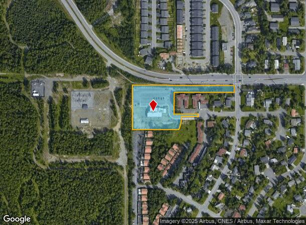
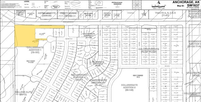
Property Record
4802 Bryn Mawr Ct, Anchorage, AK 99508

NEARBY LISTINGS FOR SALE OR LEASE
Property Detail
4802 Bryn Mawr Ct
Anchorage, AK
Collegegate #1
00511166000
COLLEGEGATE #1 TR 1B-2C
Publicschool
Anchorage
X
Alaska
0200050758D
1b-2c
0
3.22 AC
2025
Seward Hwy/Boniface-40
001602
Anchorage
14,823 SF
DEMOGRAPHICS near 4802 Bryn Mawr Ct
1 Mile
3 Mile
5 Mile
2024 Total Population
13,684
103,244
174,936
2029 Population
13,604
102,152
172,821
Pop Growth 2024-2029
(0.58%)
(1.06%)
(1.21%)
Average Age
37
36
37
2024 Total Households
5,243
38,121
67,320
HH Growth 2024-2029
(0.59%)
(1.10%)
(1.26%)
Median Household Inc
$78,129
$72,904
$74,341
Avg Household Size
2.40
2.50
2.40
2024 Avg HH Vehicles
2.00
2.00
2.00
Median Home Value
$285,945
$281,213
$299,934
Median Year Built
1978
1979
1979
Nearby Places
Map Layers
Map Styles
 Street
 Aerial
- Restaurants
- Banks
- Shops
- Fitness
- Groceries
PUBLIC TRANSPORTATION
AIRPORT
Merrill Field
DRIVE
WALK
Distance
Merrill Field
8 min
3.4 mi
Ted Stevens Anchorage International
DRIVE
WALK
Distance
Ted Stevens Anchorage International
16 min
8.7 mi
Freight Ports
Port of Anchorage
DRIVE
WALK
Distance
Port of Anchorage
15 min
6.9 mi
Nearby Properties
Address
Land Use
TOTAL SIZE
Lot Size
Zoning
Address
Land Use
TOTAL SIZE
Lot Size
Zoning
658,690 SF
70.86 AC
PLI
Address
Land Use
TOTAL SIZE
Lot Size
Zoning
22,362 SF
71.05 AC
PLI
Address
Land Use
TOTAL SIZE
Lot Size
Zoning
380,635 SF
10.82 AC
B3
Address
Land Use
TOTAL SIZE
Lot Size
Zoning
14,009 SF
24.86 AC
PLI
Address
Land Use
TOTAL SIZE
Lot Size
Zoning
160,830 SF
41.64 AC
PLI
Address
Land Use
TOTAL SIZE
Lot Size
Zoning
171,692 SF
23.09 AC
I1
Address
Land Use
TOTAL SIZE
Lot Size
Zoning
33,906 SF
40 AC
PLI
Address
Land Use
TOTAL SIZE
Lot Size
Zoning
134,626 SF
16.91 AC
PLI
Address
Land Use
TOTAL SIZE
Lot Size
Zoning
181,000 SF
7.54 AC
PLI
Address
Land Use
TOTAL SIZE
Lot Size
Zoning
179,543 SF
26.03 AC
PLI
Address
Land Use
TOTAL SIZE
Lot Size
Zoning
41,034 SF
6.28 AC
B3
Address
Land Use
TOTAL SIZE
Lot Size
Zoning
120,000 SF
9.09 AC
PLI
Address
Land Use
TOTAL SIZE
Lot Size
Zoning
171,604 SF
30.51 AC
PLI
Address
Land Use
TOTAL SIZE
Lot Size
Zoning
104,412 SF
2.79 AC
B3SL
Address
Land Use
TOTAL SIZE
Lot Size
Zoning
124,058 SF
18.15 AC
B3
Address
Land Use
TOTAL SIZE
Lot Size
Zoning
133,758 SF
2.36 AC
ROSL
Address
Land Use
TOTAL SIZE
Lot Size
Zoning
64,695 SF
13.66 AC
PLI
Address
Land Use
TOTAL SIZE
Lot Size
Zoning
320,366 SF
36.42 AC
PLI
Address
Land Use
TOTAL SIZE
Lot Size
Zoning
24,120 SF
4.68 AC
B3
Address
Land Use
TOTAL SIZE
Lot Size
Zoning
84,157 SF
3.41 AC
B3
Address
Land Use
TOTAL SIZE
Lot Size
Zoning
173,845 SF
19.98 AC
R2A
Address
Land Use
TOTAL SIZE
Lot Size
Zoning
204,769 SF
13.08 AC
R4SL
Address
Land Use
TOTAL SIZE
Lot Size
Zoning
112,874 SF
6.61 AC
ROSL
Address
Land Use
TOTAL SIZE
Lot Size
Zoning
49,217 SF
4.76 AC
B3
Address
Land Use
TOTAL SIZE
Lot Size
Zoning
171,800 SF
1.67 AC
B3
Address
Land Use
TOTAL SIZE
Lot Size
Zoning
69,627 SF
25.74 AC
PLI
Address
Land Use
TOTAL SIZE
Lot Size
Zoning
79,766 SF
4.15 AC
B3
Address
Land Use
TOTAL SIZE
Lot Size
Zoning
17,045 SF
14.66 AC
PLI
Address
Land Use
TOTAL SIZE
Lot Size
Zoning
145,475 SF
18.05 AC
B3
Address
Land Use
TOTAL SIZE
Lot Size
Zoning
68,191 SF
5.39 AC
B3
The World's #1 Commercial Real Estate Marketplace
Connect with us
© 2026 CoStar Group
The information above has been obtained from sources believed reliable. While we do not doubt its accuracy we have not verified it and make no guarantee, warranty or representation about it. It is your responsibility to independently confirm its accuracy and completeness. Any projections, opinions, assumptions, or estimates used are for example only and do not represent the current or future performance of the property. The value of this transaction to you depends on tax and other factors which should be evaluated by your tax, financial, and legal advisors. You and your advisors should conduct a careful, independent investigation of the property to determine to your satisfaction the suitability of the property for your needs.