Property Record
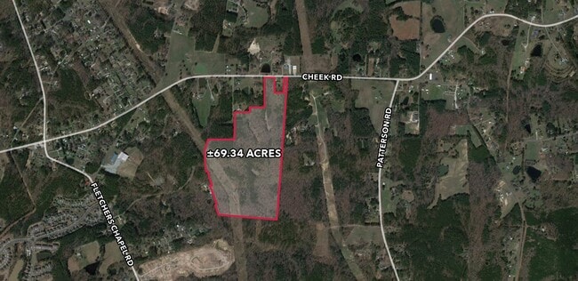
4802 Cheek Rd, Durham, NC 27704

This Property Is For Sale
Property Detail
4802 Cheek Rd
Durham-Chapel Hill, NC
HOLLY HEIGHTS/BLK:B/LT#07 -08 LT#15-20 INCL LT#23 PL:000139-000145
170507
DURHAM
Timberlandforesttreesagricultural
North Carolina
RR
77
AE The base floodplain where base flood elevations are provided. AE Zones are now used on new format FIRMs instead of A1-A30 Zones.
69.34 AC
2025
North Durham
2025
Raleigh/Durham
001806
NEARBY LISTINGS FOR SALE OR LEASE
DEMOGRAPHICS near 4802 Cheek Rd
1 mile
3 mile
5 mile
2024 Total Population
1,655
15,984
53,348
2029 Population
1,715
16,535
55,421
Pop Growth 2024-2029
+ 3.63%
+ 3.45%
+ 3.89%
Average Age
41
39
37
2024 Total Households
636
5,730
18,897
HH Growth 2024-2029
+ 3.62%
+ 3.54%
+ 4.02%
Median Household Inc
$67,910
$84,178
$68,701
Avg Household Size
2.50
2.70
2.70
2024 Avg HH Vehicles
3.00
2.00
2.00
Median Home Value
$283,606
$236,898
$246,547
Median Year Built
1991
1995
1991
Nearby Places
Map Layers
Map Styles
 Street
 Aerial
Transit
 Traffic
 Biking
Places
Listings with unknown addresses are not visible on the map
- Restaurants
- Banks
- Shops
- Fitness
- Groceries
PUBLIC TRANSPORTATION
COMMUTER RAIL
Drive
Walk
Distance
16 min
7.2 mi
AIRPORT
Raleigh-Durham International
Drive
Walk
Distance
Raleigh-Durham International
27 min
15.3 mi
Nearby Properties
Address
Land Use
TOTAL SIZE
Lot Size
Zoning
Address
Land Use
TOTAL SIZE
Lot Size
Zoning
40.81 AC
IL
Address
Land Use
TOTAL SIZE
Lot Size
Zoning
149,577 SF
34.30 AC
CG(D)
Address
Land Use
TOTAL SIZE
Lot Size
Zoning
242,250 SF
24.73 AC
IL
Address
Land Use
TOTAL SIZE
Lot Size
Zoning
237,277 SF
20.37 AC
IL
Address
Land Use
TOTAL SIZE
Lot Size
Zoning
181.12 AC
PDR 2.883
Address
Land Use
TOTAL SIZE
Lot Size
Zoning
78,205 SF
34.28 AC
RS-20
Address
Land Use
TOTAL SIZE
Lot Size
Zoning
32,200 SF
3.26 AC
CG(D)
Address
Land Use
TOTAL SIZE
Lot Size
Zoning
72,100 SF
5.86 AC
RS-10
Address
Land Use
TOTAL SIZE
Lot Size
Zoning
24,630 SF
7.62 AC
CG(D)
Address
Land Use
TOTAL SIZE
Lot Size
Zoning
260.12 AC
RR
Address
Land Use
TOTAL SIZE
Lot Size
Zoning
111.43 AC
RR
Address
Land Use
TOTAL SIZE
Lot Size
Zoning
45,143 SF
7.08 AC
CG
Address
Land Use
TOTAL SIZE
Lot Size
Zoning
2,297 SF
74.63 AC
RR
Address
Land Use
TOTAL SIZE
Lot Size
Zoning
43.28 AC
RR
Address
Land Use
TOTAL SIZE
Lot Size
Zoning
59.64 AC
IL
Address
Land Use
TOTAL SIZE
Lot Size
Zoning
175.69 AC
RR
Address
Land Use
TOTAL SIZE
Lot Size
Zoning
51.24 AC
IL
Address
Land Use
TOTAL SIZE
Lot Size
Zoning
10.66 AC
RR
Address
Land Use
TOTAL SIZE
Lot Size
Zoning
21,282 SF
17.03 AC
RR
Address
Land Use
TOTAL SIZE
Lot Size
Zoning
56.67 AC
IL
Address
Land Use
TOTAL SIZE
Lot Size
Zoning
4,274 SF
112.75 AC
RR,RS-20
Address
Land Use
TOTAL SIZE
Lot Size
Zoning
3,134 SF
90.48 AC
RR
Address
Land Use
TOTAL SIZE
Lot Size
Zoning
3,288 SF
92.02 AC
RR
Address
Land Use
TOTAL SIZE
Lot Size
Zoning
25.40 AC
PDR 3.750
Address
Land Use
TOTAL SIZE
Lot Size
Zoning
21,572 SF
3.24 AC
RR
Address
Land Use
TOTAL SIZE
Lot Size
Zoning
2,458 SF
91.38 AC
RR
Address
Land Use
TOTAL SIZE
Lot Size
Zoning
24,100 SF
6.13 AC
IL(D)
Address
Land Use
TOTAL SIZE
Lot Size
Zoning
60.73 AC
RR
Address
Land Use
TOTAL SIZE
Lot Size
Zoning
88.36 AC
RR
Address
Land Use
TOTAL SIZE
Lot Size
Zoning
21.60 AC
RR
The World's #1 Commercial Real Estate Marketplace
Connect with us
© 2026 CoStar Group
The information above has been obtained from sources believed reliable. While we do not doubt its accuracy we have not verified it and make no guarantee, warranty or representation about it. It is your responsibility to independently confirm its accuracy and completeness. Any projections, opinions, assumptions, or estimates used are for example only and do not represent the current or future performance of the property. The value of this transaction to you depends on tax and other factors which should be evaluated by your tax, financial, and legal advisors. You and your advisors should conduct a careful, independent investigation of the property to determine to your satisfaction the suitability of the property for your needs.