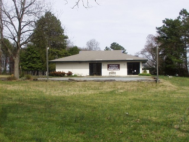
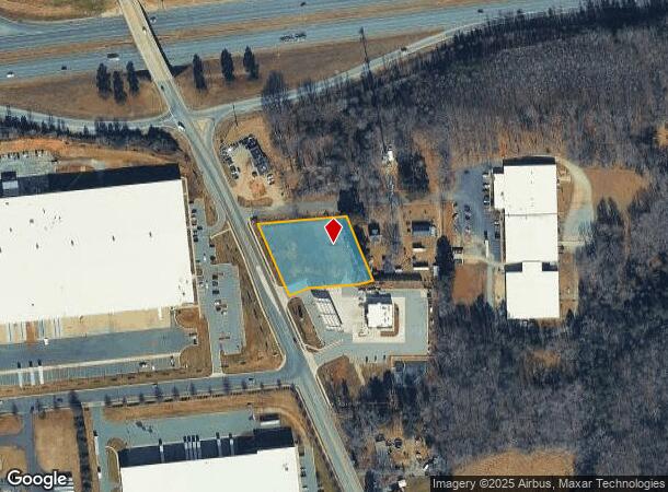
Property Record
3811 Mcconnell Rd, Greensboro, NC 27405
NEARBY LISTINGS FOR SALE OR LEASE
-
-
View all Greensboro listings for sale on LoopNet.com
Property Detail
3811 Mcconnell Rd
Greensboro-High Point, NC
Huffling & Mcdonald Land
0115501
MCCONNELL COMMERCIAL LO:1 PL:205-105
Commercialnec
Guilford
X
North Carolina
3710789400J
1
2024
1.16 AC
2025
SE Guilford County
017200
Greensboro/Winston-Salem
2,451 SF
DEMOGRAPHICS near 3811 Mcconnell Rd
1 mile
3 mile
5 mile
2024 Total Population
2,237
15,724
60,589
2029 Population
2,211
15,599
60,649
Pop Growth 2024-2029
(1.16%)
(0.79%)
+ 0.10%
Average Age
37
38
37
2024 Total Households
858
5,813
22,485
HH Growth 2024-2029
(1.05%)
(0.79%)
+ 0.17%
Median Household Inc
$55,372
$59,951
$45,993
Avg Household Size
2.60
2.60
2.50
2024 Avg HH Vehicles
2.00
2.00
2.00
Median Home Value
$178,956
$182,483
$160,468
Median Year Built
2000
1996
1979
Nearby Places
Map Layers
Map Styles
 Street
 Aerial
Transit
 Traffic
 Biking
Places
Listings with unknown addresses are not visible on the map
- Restaurants
- Banks
- Shops
- Fitness
- Groceries
PUBLIC TRANSPORTATION
COMMUTER RAIL
Greensboro Station (Piedmont - North Carolina by Train (NC Train))
Drive
Walk
Distance
Greensboro Station (Piedmont - North Carolina by Train (NC Train))
12 min
7.0 mi
AIRPORT
Piedmont Triad International
Drive
Walk
Distance
Piedmont Triad International
29 min
17.3 mi
Nearby Properties
Address
Land Use
TOTAL SIZE
Lot Size
Zoning
Address
Land Use
TOTAL SIZE
Lot Size
Zoning
2,340,205 SF
338.69 AC
LI
Address
Land Use
TOTAL SIZE
Lot Size
Zoning
1,546,815 SF
93.94 AC
CU-LI
Address
Land Use
TOTAL SIZE
Lot Size
Zoning
402,136 SF
31.27 AC
HI
Address
Land Use
TOTAL SIZE
Lot Size
Zoning
364,783 SF
30.12 AC
RM-18
Address
Land Use
TOTAL SIZE
Lot Size
Zoning
418,596 SF
23.53 AC
LI
Address
Land Use
TOTAL SIZE
Lot Size
Zoning
275,282 SF
43.43 AC
PI
Address
Land Use
TOTAL SIZE
Lot Size
Zoning
505,615 SF
39.50 AC
LI
Address
Land Use
TOTAL SIZE
Lot Size
Zoning
281,330 SF
21.18 AC
HI
Address
Land Use
TOTAL SIZE
Lot Size
Zoning
344,972 SF
65.45 AC
LI
Address
Land Use
TOTAL SIZE
Lot Size
Zoning
293,760 SF
21.94 AC
LI
Address
Land Use
TOTAL SIZE
Lot Size
Zoning
363,920 SF
34.27 AC
LI
Address
Land Use
TOTAL SIZE
Lot Size
Zoning
177,717 SF
20.81 AC
BP
Address
Land Use
TOTAL SIZE
Lot Size
Zoning
419,126 SF
33.68 AC
LI
Address
Land Use
TOTAL SIZE
Lot Size
Zoning
240,170 SF
14.01 AC
LI
Address
Land Use
TOTAL SIZE
Lot Size
Zoning
301,592 SF
19.38 AC
LI
Address
Land Use
TOTAL SIZE
Lot Size
Zoning
652,985 SF
104.62 AC
BP
Address
Land Use
TOTAL SIZE
Lot Size
Zoning
109,948 SF
392.35 AC
HI
Address
Land Use
TOTAL SIZE
Lot Size
Zoning
128,500 SF
14.15 AC
LI
Address
Land Use
TOTAL SIZE
Lot Size
Zoning
153,900 SF
14.23 AC
LI
Address
Land Use
TOTAL SIZE
Lot Size
Zoning
85,715 SF
15.34 AC
PUD
Address
Land Use
TOTAL SIZE
Lot Size
Zoning
146,028 SF
11.36 AC
BP
Address
Land Use
TOTAL SIZE
Lot Size
Zoning
67,872 SF
9.94 AC
GO-M
Address
Land Use
TOTAL SIZE
Lot Size
Zoning
86,400 SF
7.11 AC
BP
Address
Land Use
TOTAL SIZE
Lot Size
Zoning
2,768 SF
151.17 AC
HI
Address
Land Use
TOTAL SIZE
Lot Size
Zoning
4,939 SF
78.55 AC
RM-18
Address
Land Use
TOTAL SIZE
Lot Size
Zoning
48,552 SF
13.68 AC
RM-18
Address
Land Use
TOTAL SIZE
Lot Size
Zoning
39,775 SF
2.28 AC
C-M
Address
Land Use
TOTAL SIZE
Lot Size
Zoning
107,806 SF
33.49 AC
PI
Address
Land Use
TOTAL SIZE
Lot Size
Zoning
30,544 SF
27.94 AC
HI
Address
Land Use
TOTAL SIZE
Lot Size
Zoning
74,926 SF
8.57 AC
LI
The World's #1 Commercial Real Estate Marketplace
Connect with us
© 2026 CoStar Group
The information above has been obtained from sources believed reliable. While we do not doubt its accuracy we have not verified it and make no guarantee, warranty or representation about it. It is your responsibility to independently confirm its accuracy and completeness. Any projections, opinions, assumptions, or estimates used are for example only and do not represent the current or future performance of the property. The value of this transaction to you depends on tax and other factors which should be evaluated by your tax, financial, and legal advisors. You and your advisors should conduct a careful, independent investigation of the property to determine to your satisfaction the suitability of the property for your needs.