Property Record
4802 S Loop 289, Lubbock, TX 79414
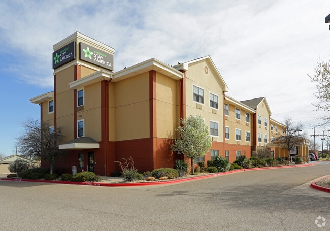
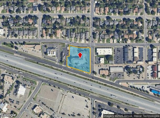

Property Detail
4802 S Loop 289
Lubbock, TX
Southwest Haven
R71789
SOUTHWEST HAVEN TR F G & H
Commercialnec
Lubbock
X
Texas
48303C0295G
f,g,h
2024
1.81 AC
2025
Lubbock
001808
Lubbock
41,277 SF
NEARBY LISTINGS FOR SALE OR LEASE
-
-
View all Lubbock listings for sale on LoopNet.com
DEMOGRAPHICS near 4802 S Loop 289
1 mile
3 mile
5 mile
2024 Total Population
12,262
106,217
221,381
2029 Population
12,878
112,112
235,040
Pop Growth 2024-2029
+ 5.02%
+ 5.55%
+ 6.17%
Average Age
39
38
36
2024 Total Households
5,513
44,535
90,261
HH Growth 2024-2029
+ 5.41%
+ 5.85%
+ 6.45%
Median Household Inc
$61,442
$63,723
$58,240
Avg Household Size
2.20
2.30
2.40
2024 Avg HH Vehicles
2.00
2.00
2.00
Median Home Value
$179,482
$198,565
$190,199
Median Year Built
1978
1979
1984
Nearby Places
Map Layers
Map Styles
 Street
 Aerial
Transit
 Traffic
 Biking
Places
Listings with unknown addresses are not visible on the map
- Restaurants
- Banks
- Shops
- Fitness
- Groceries
PUBLIC TRANSPORTATION
AIRPORT
Lubbock Preston Smith International
Drive
Walk
Distance
Lubbock Preston Smith International
24 min
16.8 mi
SALE & LEASE HISTORY
LISTING DATE
SALE/LEASE

Mar 06, 2025
For Sale
Nearby Properties
Address
Land Use
TOTAL SIZE
Lot Size
Zoning
Address
Land Use
TOTAL SIZE
Lot Size
Zoning
791,096 SF
63.76 AC
Address
Land Use
TOTAL SIZE
Lot Size
Zoning
391,942 SF
17.89 AC
Address
Land Use
TOTAL SIZE
Lot Size
Zoning
247,294 SF
13.92 AC
Address
Land Use
TOTAL SIZE
Lot Size
Zoning
276,552 SF
12.05 AC
Address
Land Use
TOTAL SIZE
Lot Size
Zoning
290,322 SF
11.96 AC
Address
Land Use
TOTAL SIZE
Lot Size
Zoning
106,894 SF
5.83 AC
Address
Land Use
TOTAL SIZE
Lot Size
Zoning
176,165 SF
36.61 AC
Address
Land Use
TOTAL SIZE
Lot Size
Zoning
64,800 SF
0.94 AC
Address
Land Use
TOTAL SIZE
Lot Size
Zoning
153,416 SF
3.14 AC
Address
Land Use
TOTAL SIZE
Lot Size
Zoning
289,796 SF
14.67 AC
Address
Land Use
TOTAL SIZE
Lot Size
Zoning
247,870 SF
11.48 AC
Address
Land Use
TOTAL SIZE
Lot Size
Zoning
186,763 SF
12 AC
Address
Land Use
TOTAL SIZE
Lot Size
Zoning
219,352 SF
21.90 AC
Address
Land Use
TOTAL SIZE
Lot Size
Zoning
215,338 SF
26.49 AC
Address
Land Use
TOTAL SIZE
Lot Size
Zoning
196,103 SF
12.33 AC
Address
Land Use
TOTAL SIZE
Lot Size
Zoning
177,643 SF
10.13 AC
Address
Land Use
TOTAL SIZE
Lot Size
Zoning
156,495 SF
15.85 AC
Address
Land Use
TOTAL SIZE
Lot Size
Zoning
138,202 SF
11.33 AC
Address
Land Use
TOTAL SIZE
Lot Size
Zoning
24,540 SF
8.06 AC
Address
Land Use
TOTAL SIZE
Lot Size
Zoning
69.21 AC
Address
Land Use
TOTAL SIZE
Lot Size
Zoning
103,560 SF
7.04 AC
Address
Land Use
TOTAL SIZE
Lot Size
Zoning
79,733 SF
3.14 AC
Address
Land Use
TOTAL SIZE
Lot Size
Zoning
172,627 SF
8.12 AC
Address
Land Use
TOTAL SIZE
Lot Size
Zoning
139,501 SF
10.56 AC
Address
Land Use
TOTAL SIZE
Lot Size
Zoning
199,854 SF
19.21 AC
Address
Land Use
TOTAL SIZE
Lot Size
Zoning
220,236 SF
13.42 AC
Address
Land Use
TOTAL SIZE
Lot Size
Zoning
198,209 SF
9.98 AC
Address
Land Use
TOTAL SIZE
Lot Size
Zoning
75,154 SF
6.95 AC
Address
Land Use
TOTAL SIZE
Lot Size
Zoning
128,355 SF
8.91 AC
Address
Land Use
TOTAL SIZE
Lot Size
Zoning
139,085 SF
17.53 AC
The World's #1 Commercial Real Estate Marketplace
Connect with us
© 2026 CoStar Group
The information above has been obtained from sources believed reliable. While we do not doubt its accuracy we have not verified it and make no guarantee, warranty or representation about it. It is your responsibility to independently confirm its accuracy and completeness. Any projections, opinions, assumptions, or estimates used are for example only and do not represent the current or future performance of the property. The value of this transaction to you depends on tax and other factors which should be evaluated by your tax, financial, and legal advisors. You and your advisors should conduct a careful, independent investigation of the property to determine to your satisfaction the suitability of the property for your needs.