Property Record
4803 Hollins Ferry Rd, Halethorpe, MD 21227


NEARBY LISTINGS FOR SALE OR LEASE
-
-
-
-
No Photo
-
-
-
-
View all Halethorpe listings for lease on LoopNet.com
Property Detail
4803 Hollins Ferry Rd
Baltimore-Columbia-Towson, MD
Hollins End
13-2500003976
15.021 AC SS HOLLINS END
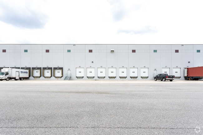
Warehouse
Baltimore
X
Maryland
2400100502G
2
2024
15.02 AC
2025
Arbutus
980200
Baltimore
290,924 SF
DEMOGRAPHICS near 4803 Hollins Ferry Rd
1 Mile
3 Mile
5 Mile
2024 Total Population
4,059
70,813
237,466
2029 Population
3,986
70,419
236,425
Pop Growth 2024-2029
(1.80%)
(0.56%)
(0.44%)
Average Age
41
37
38
2024 Total Households
1,543
25,034
88,866
HH Growth 2024-2029
(1.88%)
(0.54%)
(0.63%)
Median Household Inc
$100,420
$82,158
$67,096
Avg Household Size
2.60
2.60
2.50
2024 Avg HH Vehicles
2.00
2.00
2.00
Median Home Value
$317,862
$295,300
$270,477
Median Year Built
1955
1959
1958
Nearby Places
Map Layers
Map Styles
 Street
 Aerial
- Restaurants
- Banks
- Shops
- Fitness
- Groceries
PUBLIC TRANSPORTATION
COMMUTER RAIL
Halethorpe Marc Nb (PENN - WASHINGTON - Maryland Transit Administration)
DRIVE
WALK
Distance
Halethorpe Marc Nb (PENN - WASHINGTON - Maryland Transit Administration)
5 min
2.2 mi
Halethorpe Marc Sb (PENN - WASHINGTON - Maryland Transit Administration)
DRIVE
WALK
Distance
Halethorpe Marc Sb (PENN - WASHINGTON - Maryland Transit Administration)
5 min
2.2 mi
AIRPORT
Baltimore/Washington International Thurgood Marshall
DRIVE
WALK
Distance
Baltimore/Washington International Thurgood Marshall
11 min
5.8 mi
Freight Ports
Port of Baltimore
DRIVE
WALK
Distance
Port of Baltimore
16 min
7.7 mi
SALE & LEASE HISTORY
LISTING DATE
SALE/LEASE

Sep 25, 2016
For Lease
Nearby Properties
Address
Land Use
TOTAL SIZE
Lot Size
Zoning
Address
Land Use
TOTAL SIZE
Lot Size
Zoning
430,940 SF
18.81 AC
MXDT
Address
Land Use
TOTAL SIZE
Lot Size
Zoning
305,483 SF
11.38 AC
MXDT
Address
Land Use
TOTAL SIZE
Lot Size
Zoning
332,190 SF
21.80 AC
W1-BW
Address
Land Use
TOTAL SIZE
Lot Size
Zoning
454,684 SF
6.88 AC
W1B
Address
Land Use
TOTAL SIZE
Lot Size
Zoning
315,055 SF
9.60 AC
ML
Address
Land Use
TOTAL SIZE
Lot Size
Zoning
292,269 SF
15.86 AC
W1-BW
Address
Land Use
TOTAL SIZE
Lot Size
Zoning
231,128 SF
8.30 AC
W1-BW
Address
Land Use
TOTAL SIZE
Lot Size
Zoning
1,489,438 SF
74.22 AC
W2
Address
Land Use
TOTAL SIZE
Lot Size
Zoning
18.86 AC
DR16
Address
Land Use
TOTAL SIZE
Lot Size
Zoning
132,552 SF
47.72 AC
RED
Address
Land Use
TOTAL SIZE
Lot Size
Zoning
184,317 SF
16.23 AC
MH
Address
Land Use
TOTAL SIZE
Lot Size
Zoning
185,652 SF
18.76 AC
W1
Address
Land Use
TOTAL SIZE
Lot Size
Zoning
41.14 AC
W1-BW
Address
Land Use
TOTAL SIZE
Lot Size
Zoning
40.17 AC
DR16
Address
Land Use
TOTAL SIZE
Lot Size
Zoning
15.05 AC
R15
Address
Land Use
TOTAL SIZE
Lot Size
Zoning
187,814 SF
38.47 AC
R5
Address
Land Use
TOTAL SIZE
Lot Size
Zoning
48,300 SF
30.96 AC
ML
Address
Land Use
TOTAL SIZE
Lot Size
Zoning
109,605 SF
21.01 AC
W1
Address
Land Use
TOTAL SIZE
Lot Size
Zoning
43,456 SF
7.20 AC
RA15
Address
Land Use
TOTAL SIZE
Lot Size
Zoning
116,600 SF
8.97 AC
C4
Address
Land Use
TOTAL SIZE
Lot Size
Zoning
101,220 SF
17.51 AC
DR5.5
Address
Land Use
TOTAL SIZE
Lot Size
Zoning
338,255 SF
42.87 AC
W1-BW
Address
Land Use
TOTAL SIZE
Lot Size
Zoning
204,000 SF
7.70 AC
W1-BW
Address
Land Use
TOTAL SIZE
Lot Size
Zoning
194,652 SF
20.49 AC
W1-BW
Address
Land Use
TOTAL SIZE
Lot Size
Zoning
19.86 AC
DR16
Address
Land Use
TOTAL SIZE
Lot Size
Zoning
145,226 SF
9.24 AC
W1
Address
Land Use
TOTAL SIZE
Lot Size
Zoning
148,500 SF
5.10 AC
Address
Land Use
TOTAL SIZE
Lot Size
Zoning
21.46 AC
ML
Address
Land Use
TOTAL SIZE
Lot Size
Zoning
86,587 SF
9.86 AC
W1-BW
Address
Land Use
TOTAL SIZE
Lot Size
Zoning
132,000 SF
29.26 AC
ML
The World's #1 Commercial Real Estate Marketplace
Connect with us
© 2025 CoStar Group
The information above has been obtained from sources believed reliable. While we do not doubt its accuracy we have not verified it and make no guarantee, warranty or representation about it. It is your responsibility to independently confirm its accuracy and completeness. Any projections, opinions, assumptions, or estimates used are for example only and do not represent the current or future performance of the property. The value of this transaction to you depends on tax and other factors which should be evaluated by your tax, financial, and legal advisors. You and your advisors should conduct a careful, independent investigation of the property to determine to your satisfaction the suitability of the property for your needs.