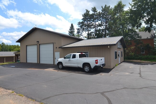
Property Record
4803 N 32Nd Ave, Wausau, WI 54401


NEARBY LISTINGS FOR SALE OR LEASE
-
-
View all Wausau listings for lease on LoopNet.com
Property Detail
4803 N 32Nd Ave
Wausau, WI
Map 13559 Certified Surv Map
146-2907-091-0997
SEC 09-29-07 PT OF NE 1/4 NE 1/4 - LOT 1 CSM VOL 59 PG 116 (#13559) (DOC #1387978)NOTE: THERE IS A DEED OVERLAP W/PCL -0946 W
Commercialnec
Marathon
X
Wisconsin
55069C0700D
1
2024
4.01 AC
2024
Wausau/Stevens Point
001500
Other Market Areas
DEMOGRAPHICS near 4803 N 32Nd Ave
1 Mile
3 Mile
5 Mile
2024 Total Population
507
5,201
35,559
2029 Population
509
5,182
35,721
Pop Growth 2024-2029
+ 0.39%
(0.37%)
+ 0.46%
Average Age
44
43
40
2024 Total Households
221
2,315
15,328
HH Growth 2024-2029
+ 0.45%
(0.35%)
+ 0.42%
Median Household Inc
$84,375
$66,384
$62,470
Avg Household Size
2.30
2.20
2.20
2024 Avg HH Vehicles
2.00
2.00
2.00
Median Home Value
$208,139
$187,179
$169,121
Median Year Built
1977
1976
1967
Nearby Places
Map Layers
Map Styles
 Street
 Aerial
- Restaurants
- Banks
- Shops
- Fitness
- Groceries
PUBLIC TRANSPORTATION
AIRPORT
Central Wisconsin
DRIVE
WALK
Distance
Central Wisconsin
32 min
24.7 mi
Freight Ports
Port Milwaukee
DRIVE
WALK
Distance
Port Milwaukee
225 min
193.0 mi
SALE & LEASE HISTORY
LISTING DATE
SALE/LEASE

Aug 27, 2021
For Lease
Nearby Properties
Address
Land Use
TOTAL SIZE
Lot Size
Zoning
Address
Land Use
TOTAL SIZE
Lot Size
Zoning
3.98 AC
UDD
Address
Land Use
TOTAL SIZE
Lot Size
Zoning
28.24 AC
UDD
Address
Land Use
TOTAL SIZE
Lot Size
Zoning
21.63 AC
UDD
Address
Land Use
TOTAL SIZE
Lot Size
Zoning
2.61 AC
R4
Address
Land Use
TOTAL SIZE
Lot Size
Zoning
4.44 AC
R4
Address
Land Use
TOTAL SIZE
Lot Size
Zoning
11.76 AC
Address
Land Use
TOTAL SIZE
Lot Size
Zoning
13.50 AC
IB
Address
Land Use
TOTAL SIZE
Lot Size
Zoning
614.45 AC
Address
Land Use
TOTAL SIZE
Lot Size
Zoning
3.79 AC
Address
Land Use
TOTAL SIZE
Lot Size
Zoning
4.85 AC
UDD
Address
Land Use
TOTAL SIZE
Lot Size
Zoning
8.49 AC
B3
Address
Land Use
TOTAL SIZE
Lot Size
Zoning
75.30 AC
Address
Land Use
TOTAL SIZE
Lot Size
Zoning
4.79 AC
IB
Address
Land Use
TOTAL SIZE
Lot Size
Zoning
6.81 AC
Address
Land Use
TOTAL SIZE
Lot Size
Zoning
15.05 AC
IB
Address
Land Use
TOTAL SIZE
Lot Size
Zoning
8.78 AC
IB
Address
Land Use
TOTAL SIZE
Lot Size
Zoning
2.50 AC
IB
Address
Land Use
TOTAL SIZE
Lot Size
Zoning
Address
Land Use
TOTAL SIZE
Lot Size
Zoning
3.46 AC
Address
Land Use
TOTAL SIZE
Lot Size
Zoning
43.01 AC
Address
Land Use
TOTAL SIZE
Lot Size
Zoning
3.61 AC
Address
Land Use
TOTAL SIZE
Lot Size
Zoning
2.19 AC
IB
Address
Land Use
TOTAL SIZE
Lot Size
Zoning
1.90 AC
Address
Land Use
TOTAL SIZE
Lot Size
Zoning
6.65 AC
Address
Land Use
TOTAL SIZE
Lot Size
Zoning
2.19 AC
UDD
Address
Land Use
TOTAL SIZE
Lot Size
Zoning
1.82 AC
B3
Address
Land Use
TOTAL SIZE
Lot Size
Zoning
37.44 AC
Address
Land Use
TOTAL SIZE
Lot Size
Zoning
6.81 AC
Address
Land Use
TOTAL SIZE
Lot Size
Zoning
2.49 AC
IB
Address
Land Use
TOTAL SIZE
Lot Size
Zoning
2 AC
IB
The World's #1 Commercial Real Estate Marketplace
Connect with us
© 2026 CoStar Group
The information above has been obtained from sources believed reliable. While we do not doubt its accuracy we have not verified it and make no guarantee, warranty or representation about it. It is your responsibility to independently confirm its accuracy and completeness. Any projections, opinions, assumptions, or estimates used are for example only and do not represent the current or future performance of the property. The value of this transaction to you depends on tax and other factors which should be evaluated by your tax, financial, and legal advisors. You and your advisors should conduct a careful, independent investigation of the property to determine to your satisfaction the suitability of the property for your needs.