Property Record
4804 Atwell Rd, Shady Side, MD 20764

This Property Is For Sale
NEARBY LISTINGS FOR SALE OR LEASE
-
-
View all Shady Side listings for sale on LoopNet.com
Property Detail
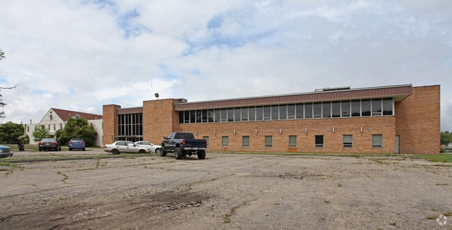
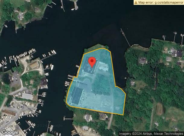
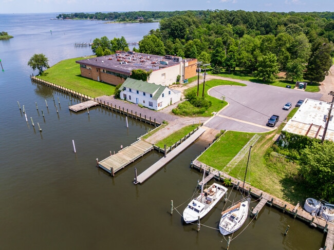
4804 Atwell Rd
07-000-01812400
Shady Side
Officebuilding
6.988 ACRES SHADY SIDE
AE
Anne Arundel
24003C0307F
Maryland
2024
6.98 AC
2025
Southern Anne Arundel
707001
Baltimore
67,421 SF
Baltimore-Columbia-Towson, MD
DEMOGRAPHICS near 4804 Atwell Rd
1 mile
3 mile
5 mile
2024 Total Population
2,864
9,231
18,830
2029 Population
2,960
9,476
19,328
Pop Growth 2024-2029
+ 3.35%
+ 2.65%
+ 2.64%
Average Age
43
43
43
2024 Total Households
1,165
3,629
7,284
HH Growth 2024-2029
+ 3.35%
+ 2.70%
+ 2.68%
Median Household Inc
$100,821
$116,071
$126,596
Avg Household Size
2.40
2.50
2.60
2024 Avg HH Vehicles
2.00
2.00
2.00
Median Home Value
$374,930
$423,018
$480,448
Median Year Built
1981
1981
1979
Nearby Places
Map Layers
Map Styles
 Street
 Aerial
Transit
 Traffic
 Biking
Places
Listings with unknown addresses are not visible on the map
- Restaurants
- Banks
- Shops
- Fitness
- Groceries
PUBLIC TRANSPORTATION
AIRPORT
Ronald Reagan Washington Ntl
Drive
Walk
Distance
Ronald Reagan Washington Ntl
64 min
38.1 mi
Baltimore/Washington International Thurgood Marshall
Drive
Walk
Distance
Baltimore/Washington International Thurgood Marshall
61 min
38.9 mi
Freight Ports
Port of Baltimore
Drive
Walk
Distance
Port of Baltimore
68 min
44.5 mi
Nearby Properties
Address
Land Use
TOTAL SIZE
Lot Size
Zoning
Address
Land Use
TOTAL SIZE
Lot Size
Zoning
341.13 AC
R5
Address
Land Use
TOTAL SIZE
Lot Size
Zoning
65,982 SF
17.03 AC
R1
Address
Land Use
TOTAL SIZE
Lot Size
Zoning
8.38 AC
R1
Address
Land Use
TOTAL SIZE
Lot Size
Zoning
13,024 SF
5.51 AC
MC
Address
Land Use
TOTAL SIZE
Lot Size
Zoning
33,552 SF
3.77 AC
C3
Address
Land Use
TOTAL SIZE
Lot Size
Zoning
11,367 SF
2.96 AC
C1
Address
Land Use
TOTAL SIZE
Lot Size
Zoning
11,776 SF
1.92 AC
R2
Address
Land Use
TOTAL SIZE
Lot Size
Zoning
13,706 SF
20 AC
RA
Address
Land Use
TOTAL SIZE
Lot Size
Zoning
9,906 SF
1.04 AC
MC
Address
Land Use
TOTAL SIZE
Lot Size
Zoning
15,106 SF
13.34 AC
MC
Address
Land Use
TOTAL SIZE
Lot Size
Zoning
7,796 SF
9.38 AC
RA
Address
Land Use
TOTAL SIZE
Lot Size
Zoning
13,429 SF
1.20 AC
R2
Address
Land Use
TOTAL SIZE
Lot Size
Zoning
6,727 SF
6.20 AC
OS
Address
Land Use
TOTAL SIZE
Lot Size
Zoning
11,701 SF
8.03 AC
OS
Address
Land Use
TOTAL SIZE
Lot Size
Zoning
7,873 SF
2.13 AC
R2
Address
Land Use
TOTAL SIZE
Lot Size
Zoning
9,240 SF
1.49 AC
C3
Address
Land Use
TOTAL SIZE
Lot Size
Zoning
5,904 SF
10.79 AC
RA
Address
Land Use
TOTAL SIZE
Lot Size
Zoning
7,298 SF
2.22 AC
R2
Address
Land Use
TOTAL SIZE
Lot Size
Zoning
11,859 SF
3.22 AC
R1
Address
Land Use
TOTAL SIZE
Lot Size
Zoning
3,534 SF
4.64 AC
OS
Address
Land Use
TOTAL SIZE
Lot Size
Zoning
7,401 SF
5.03 AC
RA
Address
Land Use
TOTAL SIZE
Lot Size
Zoning
6,834 SF
3.78 AC
RA
Address
Land Use
TOTAL SIZE
Lot Size
Zoning
9,900 SF
44.58 AC
OS
Address
Land Use
TOTAL SIZE
Lot Size
Zoning
6,984 SF
5.13 AC
R1
Address
Land Use
TOTAL SIZE
Lot Size
Zoning
9,522 SF
2.44 AC
Address
Land Use
TOTAL SIZE
Lot Size
Zoning
8,410 SF
2 AC
Address
Land Use
TOTAL SIZE
Lot Size
Zoning
7,503 SF
1.09 AC
R1
Address
Land Use
TOTAL SIZE
Lot Size
Zoning
7,125 SF
1.68 AC
R5
Address
Land Use
TOTAL SIZE
Lot Size
Zoning
7,824 SF
2.98 AC
MA3
The World's #1 Commercial Real Estate Marketplace
Connect with us
© 2026 CoStar Group
The information above has been obtained from sources believed reliable. While we do not doubt its accuracy we have not verified it and make no guarantee, warranty or representation about it. It is your responsibility to independently confirm its accuracy and completeness. Any projections, opinions, assumptions, or estimates used are for example only and do not represent the current or future performance of the property. The value of this transaction to you depends on tax and other factors which should be evaluated by your tax, financial, and legal advisors. You and your advisors should conduct a careful, independent investigation of the property to determine to your satisfaction the suitability of the property for your needs.