Property Record
4805 N Tanglewood Ave, Hernando, FL 34442
NEARBY LISTINGS FOR SALE OR LEASE
-
-
View all Hernando listings for sale on LoopNet.com
Property Detail
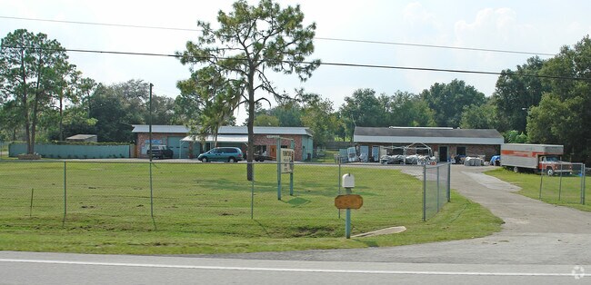
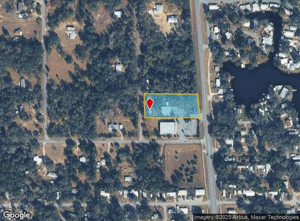
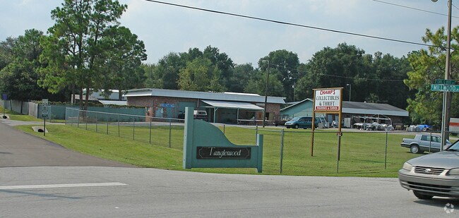
4805 N Tanglewood Ave
Homosassa Springs, FL
Tanglewood
19E-18S-10-0010-00000-0930
TANGLEWOOD PB 5 PG 111 LOT 93
Storemultistory
Citrus
X
Florida
12017C0217D
93
2024
1.45 AC
2025
Florida Central North Area
450106
Other Market Areas
5,686 SF
DEMOGRAPHICS near 4805 N Tanglewood Ave
1 Mile
3 Mile
5 Mile
2024 Total Population
2,014
8,968
30,891
2029 Population
2,319
10,290
35,209
Pop Growth 2024-2029
+ 15.14%
+ 14.74%
+ 13.98%
Average Age
53
53
51
2024 Total Households
997
4,261
14,136
HH Growth 2024-2029
+ 14.94%
+ 14.53%
+ 13.75%
Median Household Inc
$39,384
$45,701
$46,763
Avg Household Size
1.90
2.10
2.10
2024 Avg HH Vehicles
2.00
2.00
2.00
Median Home Value
$197,077
$207,465
$195,191
Median Year Built
1987
1990
1989
Nearby Places
Map Layers
Map Styles
 Street
 Aerial
- Restaurants
- Banks
- Shops
- Fitness
- Groceries
Nearby Properties
Address
Land Use
TOTAL SIZE
Lot Size
Zoning
Address
Land Use
TOTAL SIZE
Lot Size
Zoning
84,611 SF
33.22 AC
PSI
Address
Land Use
TOTAL SIZE
Lot Size
Zoning
119,399 SF
4.77 AC
GNC
Address
Land Use
TOTAL SIZE
Lot Size
Zoning
74,320 SF
4.51 AC
GNC
Address
Land Use
TOTAL SIZE
Lot Size
Zoning
40,648 SF
4.85 AC
GNC
Address
Land Use
TOTAL SIZE
Lot Size
Zoning
18,114 SF
9.11 AC
GNC
Address
Land Use
TOTAL SIZE
Lot Size
Zoning
133,760 SF
4.21 AC
IND
Address
Land Use
TOTAL SIZE
Lot Size
Zoning
42,640 SF
5.04 AC
GNC
Address
Land Use
TOTAL SIZE
Lot Size
Zoning
28,222 SF
15.81 AC
LDRMH
Address
Land Use
TOTAL SIZE
Lot Size
Zoning
3,914 SF
5.02 AC
CLR
Address
Land Use
TOTAL SIZE
Lot Size
Zoning
31,200 SF
3.58 AC
GNC
Address
Land Use
TOTAL SIZE
Lot Size
Zoning
8,650 SF
3.55 AC
GNC
Address
Land Use
TOTAL SIZE
Lot Size
Zoning
24.12 AC
RVP
Address
Land Use
TOTAL SIZE
Lot Size
Zoning
29,130 SF
3.27 AC
GNC
Address
Land Use
TOTAL SIZE
Lot Size
Zoning
11,384 SF
6.96 AC
GNC
Address
Land Use
TOTAL SIZE
Lot Size
Zoning
18,900 SF
7.13 AC
IND
Address
Land Use
TOTAL SIZE
Lot Size
Zoning
8,574 SF
1.13 AC
MDRMH
Address
Land Use
TOTAL SIZE
Lot Size
Zoning
9,230 SF
1.52 AC
PDR
Address
Land Use
TOTAL SIZE
Lot Size
Zoning
1,200 SF
43.89 AC
PSI
Address
Land Use
TOTAL SIZE
Lot Size
Zoning
33,890 SF
4.32 AC
IND
Address
Land Use
TOTAL SIZE
Lot Size
Zoning
9,780 SF
11.86 AC
CL
Address
Land Use
TOTAL SIZE
Lot Size
Zoning
14,672 SF
1.59 AC
IND
Address
Land Use
TOTAL SIZE
Lot Size
Zoning
17,664 SF
2.02 AC
GNC
Address
Land Use
TOTAL SIZE
Lot Size
Zoning
20,038 SF
4.78 AC
CLR
Address
Land Use
TOTAL SIZE
Lot Size
Zoning
18,666 SF
1.87 AC
GNC
Address
Land Use
TOTAL SIZE
Lot Size
Zoning
21,120 SF
1.75 AC
IND
Address
Land Use
TOTAL SIZE
Lot Size
Zoning
48,545 SF
7.22 AC
HDR
Address
Land Use
TOTAL SIZE
Lot Size
Zoning
26,964 SF
3.75 AC
PSI
Address
Land Use
TOTAL SIZE
Lot Size
Zoning
18,000 SF
1.78 AC
IND
Address
Land Use
TOTAL SIZE
Lot Size
Zoning
25,494 SF
4.03 AC
IND
Address
Land Use
TOTAL SIZE
Lot Size
Zoning
9,154 SF
5.18 AC
GNC
The World's #1 Commercial Real Estate Marketplace
Connect with us
© 2025 CoStar Group
The information above has been obtained from sources believed reliable. While we do not doubt its accuracy we have not verified it and make no guarantee, warranty or representation about it. It is your responsibility to independently confirm its accuracy and completeness. Any projections, opinions, assumptions, or estimates used are for example only and do not represent the current or future performance of the property. The value of this transaction to you depends on tax and other factors which should be evaluated by your tax, financial, and legal advisors. You and your advisors should conduct a careful, independent investigation of the property to determine to your satisfaction the suitability of the property for your needs.