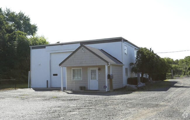
Property Record
4806 Highway 33, Wall Township, NJ 07753


NEARBY LISTINGS FOR SALE OR LEASE
Property Detail
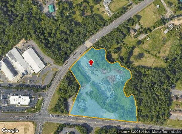
4806 Highway 33
52-00910-0000-00002
Monmouth
Retailwithmorethanonenonretailuse
New Jersey
AE
2
34025C0326F
9.20 AC
2024
Western Monmouth
2025
Northern New Jersey
807800
New York-Jersey City-White Plains, NY-NJ
3,484 SF
DEMOGRAPHICS near 4806 Highway 33
1 Mile
3 Mile
5 Mile
2024 Total Population
797
19,868
65,599
2029 Population
775
19,692
65,307
Pop Growth 2024-2029
(2.76%)
(0.89%)
(0.45%)
Average Age
39
46
45
2024 Total Households
295
8,490
26,837
HH Growth 2024-2029
(3.05%)
(1.39%)
(0.79%)
Median Household Inc
$108,806
$93,673
$99,164
Avg Household Size
2.60
2.30
2.40
2024 Avg HH Vehicles
2.00
2.00
2.00
Median Home Value
$408,333
$396,155
$449,854
Median Year Built
1988
1991
1982
Nearby Places
Map Layers
Map Styles
 Street
 Aerial
- Restaurants
- Banks
- Shops
- Fitness
- Groceries
Nearby Properties
Address
Land Use
TOTAL SIZE
Lot Size
Zoning
Address
Land Use
TOTAL SIZE
Lot Size
Zoning
434,405 SF
52.92 AC
RT66
Address
Land Use
TOTAL SIZE
Lot Size
Zoning
4,289 SF
94.37 AC
CCRC
Address
Land Use
TOTAL SIZE
Lot Size
Zoning
134,075 SF
339.89 AC
OSGS
Address
Land Use
TOTAL SIZE
Lot Size
Zoning
37.47 AC
AH
Address
Land Use
TOTAL SIZE
Lot Size
Zoning
152,121 SF
22.16 AC
OR10
Address
Land Use
TOTAL SIZE
Lot Size
Zoning
25.37 AC
C-1
Address
Land Use
TOTAL SIZE
Lot Size
Zoning
192,708 SF
33.36 AC
OR10
Address
Land Use
TOTAL SIZE
Lot Size
Zoning
181,064 SF
14.62 AC
IL
Address
Land Use
TOTAL SIZE
Lot Size
Zoning
3,040 SF
194.08 AC
OSGS
Address
Land Use
TOTAL SIZE
Lot Size
Zoning
183,932 SF
23.51 AC
IL
Address
Land Use
TOTAL SIZE
Lot Size
Zoning
13,200 SF
18.63 AC
PUDR
Address
Land Use
TOTAL SIZE
Lot Size
Zoning
25,536 SF
21.95 AC
OR10
Address
Land Use
TOTAL SIZE
Lot Size
Zoning
8,100 SF
50.70 AC
IOP
Address
Land Use
TOTAL SIZE
Lot Size
Zoning
28,819 SF
13.59 AC
ES
Address
Land Use
TOTAL SIZE
Lot Size
Zoning
912 SF
201.36 AC
RRC
Address
Land Use
TOTAL SIZE
Lot Size
Zoning
117,915 SF
17.32 AC
C-1
Address
Land Use
TOTAL SIZE
Lot Size
Zoning
427.37 AC
POS
Address
Land Use
TOTAL SIZE
Lot Size
Zoning
3,400 SF
262.97 AC
AI
Address
Land Use
TOTAL SIZE
Lot Size
Zoning
108,661 SF
11.29 AC
R-4
Address
Land Use
TOTAL SIZE
Lot Size
Zoning
332,213 SF
26.55 AC
OR10
Address
Land Use
TOTAL SIZE
Lot Size
Zoning
103.42 AC
OSGS
Address
Land Use
TOTAL SIZE
Lot Size
Zoning
379 AC
SF80
Address
Land Use
TOTAL SIZE
Lot Size
Zoning
647.36 AC
HD03
Address
Land Use
TOTAL SIZE
Lot Size
Zoning
99.06 AC
MFG
Address
Land Use
TOTAL SIZE
Lot Size
Zoning
22.38 AC
IO20
Address
Land Use
TOTAL SIZE
Lot Size
Zoning
61,143 SF
8.69 AC
HCC
Address
Land Use
TOTAL SIZE
Lot Size
Zoning
71,660 SF
4.45 AC
C-1
Address
Land Use
TOTAL SIZE
Lot Size
Zoning
7,350 SF
161.08 AC
MFG
Address
Land Use
TOTAL SIZE
Lot Size
Zoning
12.74 AC
CCRC
Address
Land Use
TOTAL SIZE
Lot Size
Zoning
3.61 AC
AR3P
The World's #1 Commercial Real Estate Marketplace
Connect with us
© 2025 CoStar Group
The information above has been obtained from sources believed reliable. While we do not doubt its accuracy we have not verified it and make no guarantee, warranty or representation about it. It is your responsibility to independently confirm its accuracy and completeness. Any projections, opinions, assumptions, or estimates used are for example only and do not represent the current or future performance of the property. The value of this transaction to you depends on tax and other factors which should be evaluated by your tax, financial, and legal advisors. You and your advisors should conduct a careful, independent investigation of the property to determine to your satisfaction the suitability of the property for your needs.