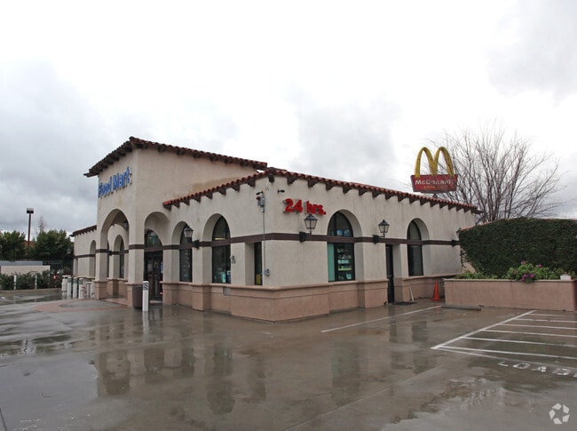
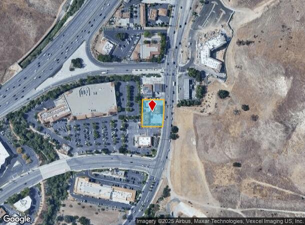
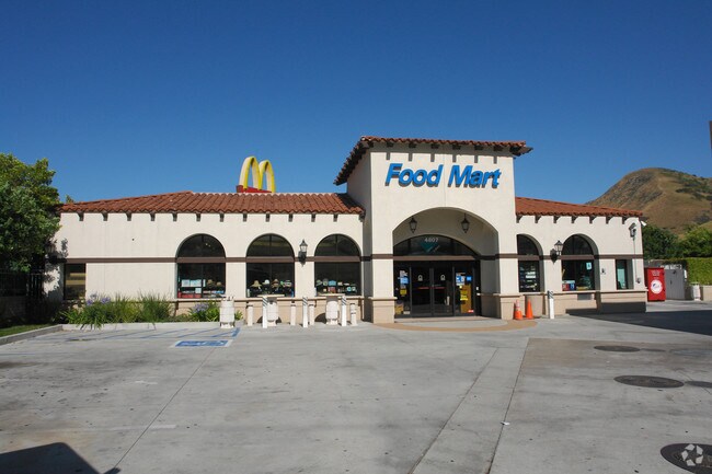
Property Record
4807 Las Virgenes Rd, Calabasas, CA 91302
NEARBY LISTINGS FOR SALE OR LEASE
Property Detail
4807 Las Virgenes Rd
Los Angeles-Long Beach-Glendale, CA
Parcel Map No 3120
2064-002-048
P M 43-49 LOT 1
Servicestation
Los Angeles
X
California
06037C1264G
1
2024
0.55 AC
2025
Calabasas/Westlake Vill
800337
Los Angeles
3,150 SF
DEMOGRAPHICS near 4807 Las Virgenes Rd
1 Mile
3 Mile
5 Mile
2024 Total Population
4,159
21,603
86,729
2029 Population
4,008
20,884
83,946
Pop Growth 2024-2029
(3.63%)
(3.33%)
(3.21%)
Average Age
41
42
43
2024 Total Households
1,629
8,169
31,381
HH Growth 2024-2029
(3.81%)
(3.56%)
(3.46%)
Median Household Inc
$113,575
$141,789
$142,249
Avg Household Size
2.60
2.60
2.70
2024 Avg HH Vehicles
2.00
2.00
2.00
Median Home Value
$868,491
$1,066,831
$1,022,058
Median Year Built
1984
1984
1976
Nearby Places
Map Layers
Map Styles
 Street
 Aerial
- Restaurants
- Banks
- Shops
- Fitness
- Groceries
PUBLIC TRANSPORTATION
AIRPORT
Bob Hope
DRIVE
WALK
Distance
Bob Hope
32 min
23.6 mi
Los Angeles International
DRIVE
WALK
Distance
Los Angeles International
41 min
31.8 mi
Freight Ports
The Port of Hueneme
DRIVE
WALK
Distance
The Port of Hueneme
46 min
33.6 mi
Nearby Properties
Address
Land Use
TOTAL SIZE
Lot Size
Zoning
Address
Land Use
TOTAL SIZE
Lot Size
Zoning
294,536 SF
16.70 AC
CS R-MF*
Address
Land Use
TOTAL SIZE
Lot Size
Zoning
210,268 SF
13.77 AC
CS R-MF*
Address
Land Use
TOTAL SIZE
Lot Size
Zoning
198,668 SF
17.98 AC
CSCB*
Address
Land Use
TOTAL SIZE
Lot Size
Zoning
107,395 SF
4.98 AC
CPD
Address
Land Use
TOTAL SIZE
Lot Size
Zoning
257,241 SF
29.19 AC
LCRPD15000
Address
Land Use
TOTAL SIZE
Lot Size
Zoning
237,492 SF
18.84 AC
LCRPD15000
Address
Land Use
TOTAL SIZE
Lot Size
Zoning
280,491 SF
4.74 AC
CSCM
Address
Land Use
TOTAL SIZE
Lot Size
Zoning
257,344 SF
4.09 AC
CSCM
Address
Land Use
TOTAL SIZE
Lot Size
Zoning
110,229 SF
5.31 AC
CSCB
Address
Land Use
TOTAL SIZE
Lot Size
Zoning
230,800 SF
4.39 AC
LCMP
Address
Land Use
TOTAL SIZE
Lot Size
Zoning
98,127 SF
2.56 AC
AHRA20000*
Address
Land Use
TOTAL SIZE
Lot Size
Zoning
92,367 SF
4.16 AC
CSCR-SC*
Address
Land Use
TOTAL SIZE
Lot Size
Zoning
98,270 SF
4.69 AC
CSCM
Address
Land Use
TOTAL SIZE
Lot Size
Zoning
101,087 SF
4.47 AC
Address
Land Use
TOTAL SIZE
Lot Size
Zoning
65,706 SF
1.24 AC
LACRA 1-A2
Address
Land Use
TOTAL SIZE
Lot Size
Zoning
104,838 SF
2.41 AC
CSCR-SC*
Address
Land Use
TOTAL SIZE
Lot Size
Zoning
133,511 SF
16.96 AC
C2
Address
Land Use
TOTAL SIZE
Lot Size
Zoning
157,896 SF
5.74 AC
AH
Address
Land Use
TOTAL SIZE
Lot Size
Zoning
58,094 SF
4.51 AC
CSCR-SC*
Address
Land Use
TOTAL SIZE
Lot Size
Zoning
215,232 SF
18.99 AC
AH BP-M-FC
Address
Land Use
TOTAL SIZE
Lot Size
Zoning
94,826 SF
5.32 AC
AHC
Address
Land Use
TOTAL SIZE
Lot Size
Zoning
39,412 SF
104.84 AC
LC A2-1*
Address
Land Use
TOTAL SIZE
Lot Size
Zoning
36,042 SF
4.97 AC
LCM1*
Address
Land Use
TOTAL SIZE
Lot Size
Zoning
78,847 SF
3.37 AC
CSCM
Address
Land Use
TOTAL SIZE
Lot Size
Zoning
44,244 SF
4.36 AC
CSCR
Address
Land Use
TOTAL SIZE
Lot Size
Zoning
89,864 SF
3.16 AC
CSCR-SC*
Address
Land Use
TOTAL SIZE
Lot Size
Zoning
87,138 SF
5.02 AC
CSCM
Address
Land Use
TOTAL SIZE
Lot Size
Zoning
83,177 SF
3.87 AC
LCRPD15000
Address
Land Use
TOTAL SIZE
Lot Size
Zoning
265,295 SF
4.38 AC
LCM1
Address
Land Use
TOTAL SIZE
Lot Size
Zoning
96,344 SF
11.17 AC
CSCR-OS-SC
The World's #1 Commercial Real Estate Marketplace
Connect with us
© 2025 CoStar Group
The information above has been obtained from sources believed reliable. While we do not doubt its accuracy we have not verified it and make no guarantee, warranty or representation about it. It is your responsibility to independently confirm its accuracy and completeness. Any projections, opinions, assumptions, or estimates used are for example only and do not represent the current or future performance of the property. The value of this transaction to you depends on tax and other factors which should be evaluated by your tax, financial, and legal advisors. You and your advisors should conduct a careful, independent investigation of the property to determine to your satisfaction the suitability of the property for your needs.