Property Record
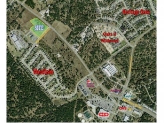
4807 Moreland Dr, Georgetown, TX 78633
Property Detail
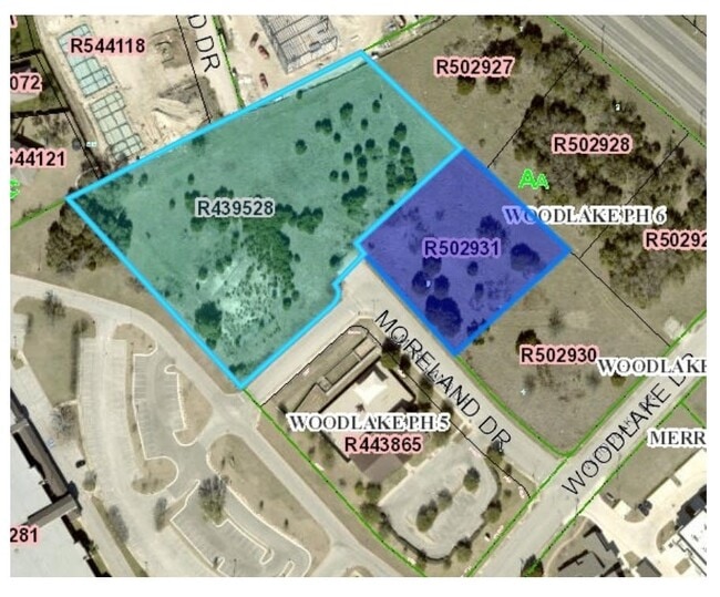
4807 Moreland Dr
Austin-Round Rock-San Marcos, TX
S9883 - WOODLAKE PH 6, BLOCK A, LOT 5, ACRES 1.025
R502931
WILLIAMSON
Commercialacreage
Texas
3-C-1
5
B and X Area of moderate flood hazard, usually the area between the limits of the 100-year and 500-year floods.
1.02 AC
2024
Georgetown
2025
Austin
020109
NEARBY LISTINGS FOR SALE OR LEASE
DEMOGRAPHICS near 4807 Moreland Dr
1 mile
3 mile
5 mile
2025 Total Population
5,736
36,162
77,231
2030 Population
6,510
41,209
89,541
Pop Growth 2025-2030
+ 13.49%
+ 13.96%
+ 15.94%
Average Age
50
54
50
2025 Total Households
2,565
16,692
34,106
HH Growth 2025-2030
+ 13.92%
+ 14.32%
+ 16.30%
Median Household Inc
$125,495
$106,433
$106,562
Avg Household Size
2.20
2.10
2.20
2025 Avg HH Vehicles
2.00
2.00
2.00
Median Home Value
$479,571
$487,946
$493,924
Median Year Built
2009
2006
2008
Nearby Places
Map Layers
Map Styles
 Street
 Aerial
Transit
 Traffic
 Biking
Places
Listings with unknown addresses are not visible on the map
- Restaurants
- Banks
- Shops
- Fitness
- Groceries
PUBLIC TRANSPORTATION
AIRPORT
Killeen Municipal
Drive
Walk
Distance
Killeen Municipal
53 min
38.4 mi
Robert Gray AAF
Drive
Walk
Distance
Robert Gray AAF
57 min
39.2 mi
Freight Ports
Calhoun Port
Drive
Walk
Distance
Calhoun Port
219 min
191.0 mi
SALE & LEASE HISTORY
LISTING DATE
SALE/LEASE

Aug 31, 2020
For Sale
Nearby Properties
Address
Land Use
TOTAL SIZE
Lot Size
Zoning
Address
Land Use
TOTAL SIZE
Lot Size
Zoning
389,888 SF
30 AC
1-MF
Address
Land Use
TOTAL SIZE
Lot Size
Zoning
310,849 SF
13.15 AC
Address
Land Use
TOTAL SIZE
Lot Size
Zoning
233,173 SF
9.89 AC
Address
Land Use
TOTAL SIZE
Lot Size
Zoning
120,653 SF
12.83 AC
Address
Land Use
TOTAL SIZE
Lot Size
Zoning
592 SF
42.32 AC
Address
Land Use
TOTAL SIZE
Lot Size
Zoning
88,851 SF
11.06 AC
Address
Land Use
TOTAL SIZE
Lot Size
Zoning
176,065 SF
19.48 AC
Address
Land Use
TOTAL SIZE
Lot Size
Zoning
129,281 SF
17.68 AC
Address
Land Use
TOTAL SIZE
Lot Size
Zoning
123,984 SF
6.89 AC
Address
Land Use
TOTAL SIZE
Lot Size
Zoning
50,543 SF
10.49 AC
Address
Land Use
TOTAL SIZE
Lot Size
Zoning
209,508 SF
13.25 AC
Address
Land Use
TOTAL SIZE
Lot Size
Zoning
192.21 AC
Address
Land Use
TOTAL SIZE
Lot Size
Zoning
98,769 SF
10.76 AC
Address
Land Use
TOTAL SIZE
Lot Size
Zoning
98,769 SF
10.76 AC
Address
Land Use
TOTAL SIZE
Lot Size
Zoning
62,545 SF
4.51 AC
3-C-3
Address
Land Use
TOTAL SIZE
Lot Size
Zoning
14.60 AC
Address
Land Use
TOTAL SIZE
Lot Size
Zoning
85,701 SF
5.65 AC
Address
Land Use
TOTAL SIZE
Lot Size
Zoning
100,080 SF
3 AC
Address
Land Use
TOTAL SIZE
Lot Size
Zoning
113,735 SF
4.59 AC
3-C-3
Address
Land Use
TOTAL SIZE
Lot Size
Zoning
72.01 AC
Address
Land Use
TOTAL SIZE
Lot Size
Zoning
36,226 SF
6.27 AC
Address
Land Use
TOTAL SIZE
Lot Size
Zoning
49,419 SF
14.86 AC
Address
Land Use
TOTAL SIZE
Lot Size
Zoning
86,726 SF
6.21 AC
Address
Land Use
TOTAL SIZE
Lot Size
Zoning
Address
Land Use
TOTAL SIZE
Lot Size
Zoning
12,241 SF
20.18 AC
Address
Land Use
TOTAL SIZE
Lot Size
Zoning
54,390 SF
9.57 AC
Address
Land Use
TOTAL SIZE
Lot Size
Zoning
36,686 SF
4.40 AC
Address
Land Use
TOTAL SIZE
Lot Size
Zoning
9.66 AC
Address
Land Use
TOTAL SIZE
Lot Size
Zoning
6.64 AC
Address
Land Use
TOTAL SIZE
Lot Size
Zoning
30,112 SF
4.58 AC
The World's #1 Commercial Real Estate Marketplace
Connect with us
© 2026 CoStar Group
The information above has been obtained from sources believed reliable. While we do not doubt its accuracy we have not verified it and make no guarantee, warranty or representation about it. It is your responsibility to independently confirm its accuracy and completeness. Any projections, opinions, assumptions, or estimates used are for example only and do not represent the current or future performance of the property. The value of this transaction to you depends on tax and other factors which should be evaluated by your tax, financial, and legal advisors. You and your advisors should conduct a careful, independent investigation of the property to determine to your satisfaction the suitability of the property for your needs.