Property Record
480A N Energy Rd, Reliance, WY 82943


NEARBY LISTINGS FOR SALE OR LEASE
-
-
View all Reliance listings for sale on LoopNet.com
Property Detail
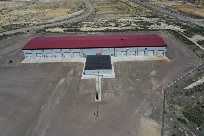
480A N Energy Rd
Rock Springs, WY
T19N R105W SEC 2 SW4NW4 & N2N2NW4SW4
04-1905-02-2-00-031.00
Sweetwater
Warehouse
Wyoming
2024
49.75 AC
2025
I-80 Corridor/Cheyenne
970800
Other Market Areas
41,406 SF
DEMOGRAPHICS near 480A N Energy Rd
1 Mile
3 Mile
5 Mile
2024 Total Population
324
5,073
17,020
2029 Population
317
4,932
16,677
Pop Growth 2024-2029
(2.16%)
(2.78%)
(2.02%)
Average Age
35
37
37
2024 Total Households
132
1,868
6,631
HH Growth 2024-2029
(2.27%)
(2.68%)
(1.85%)
Median Household Inc
$34,166
$74,146
$73,987
Avg Household Size
2.40
2.50
2.50
2024 Avg HH Vehicles
2.00
2.00
2.00
Median Home Value
$59,868
$288,043
$249,722
Median Year Built
1979
1986
1983
Nearby Places
Map Layers
Map Styles
 Street
 Aerial
- Restaurants
- Banks
- Shops
- Fitness
- Groceries
SALE & LEASE HISTORY
LISTING DATE
SALE/LEASE

Mar 01, 2021
For Sale
Nearby Properties
Address
Land Use
TOTAL SIZE
Lot Size
Zoning
Address
Land Use
TOTAL SIZE
Lot Size
Zoning
79,084 SF
24.51 AC
Address
Land Use
TOTAL SIZE
Lot Size
Zoning
129,486 SF
5.75 AC
Address
Land Use
TOTAL SIZE
Lot Size
Zoning
49,204 SF
15.03 AC
Address
Land Use
TOTAL SIZE
Lot Size
Zoning
59,415 SF
8.75 AC
Address
Land Use
TOTAL SIZE
Lot Size
Zoning
38,421 SF
9.72 AC
Address
Land Use
TOTAL SIZE
Lot Size
Zoning
13,837 SF
4.32 AC
Address
Land Use
TOTAL SIZE
Lot Size
Zoning
26,220 SF
7.33 AC
Address
Land Use
TOTAL SIZE
Lot Size
Zoning
157.92 AC
Address
Land Use
TOTAL SIZE
Lot Size
Zoning
23,190 SF
9.98 AC
Address
Land Use
TOTAL SIZE
Lot Size
Zoning
18,750 SF
1.83 AC
Address
Land Use
TOTAL SIZE
Lot Size
Zoning
14,836 SF
14.62 AC
Address
Land Use
TOTAL SIZE
Lot Size
Zoning
17,340 SF
1.29 AC
Address
Land Use
TOTAL SIZE
Lot Size
Zoning
19,032 SF
1.79 AC
Address
Land Use
TOTAL SIZE
Lot Size
Zoning
10,796 SF
2.83 AC
Address
Land Use
TOTAL SIZE
Lot Size
Zoning
32,264 SF
2.66 AC
Address
Land Use
TOTAL SIZE
Lot Size
Zoning
4,662 SF
3.73 AC
Address
Land Use
TOTAL SIZE
Lot Size
Zoning
32,536 SF
37.53 AC
Address
Land Use
TOTAL SIZE
Lot Size
Zoning
38,864 SF
4.27 AC
Address
Land Use
TOTAL SIZE
Lot Size
Zoning
27,064 SF
2.16 AC
Address
Land Use
TOTAL SIZE
Lot Size
Zoning
20,000 SF
5.04 AC
Address
Land Use
TOTAL SIZE
Lot Size
Zoning
42,150 SF
8.40 AC
Address
Land Use
TOTAL SIZE
Lot Size
Zoning
42,034 SF
6.55 AC
Address
Land Use
TOTAL SIZE
Lot Size
Zoning
12,600 SF
1.99 AC
Address
Land Use
TOTAL SIZE
Lot Size
Zoning
30,645 SF
10.86 AC
Address
Land Use
TOTAL SIZE
Lot Size
Zoning
12,500 SF
4.91 AC
Address
Land Use
TOTAL SIZE
Lot Size
Zoning
12,843 SF
4.11 AC
Address
Land Use
TOTAL SIZE
Lot Size
Zoning
16,760 SF
3 AC
Address
Land Use
TOTAL SIZE
Lot Size
Zoning
8,000 SF
1.65 AC
Address
Land Use
TOTAL SIZE
Lot Size
Zoning
9,920 SF
1.15 AC
The World's #1 Commercial Real Estate Marketplace
Connect with us
© 2026 CoStar Group
The information above has been obtained from sources believed reliable. While we do not doubt its accuracy we have not verified it and make no guarantee, warranty or representation about it. It is your responsibility to independently confirm its accuracy and completeness. Any projections, opinions, assumptions, or estimates used are for example only and do not represent the current or future performance of the property. The value of this transaction to you depends on tax and other factors which should be evaluated by your tax, financial, and legal advisors. You and your advisors should conduct a careful, independent investigation of the property to determine to your satisfaction the suitability of the property for your needs.