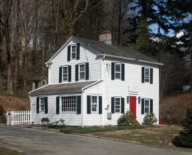
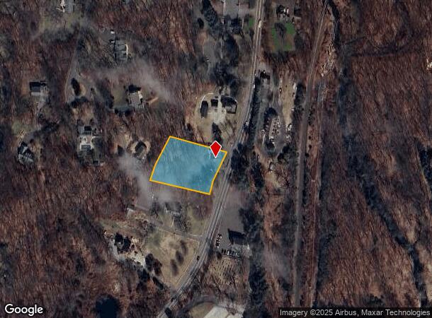
Property Record
481 Danbury Rd, Wilton, CT 06897
NEARBY LISTINGS FOR SALE OR LEASE
Property Detail
481 Danbury Rd
Commercialnec
Fairfield
X
Connecticut
09001C0381F
1.08 AC
2025
Wilton
2025
Westchester/So Connecticut
045102
Bridgeport-Stamford-Norwalk, CT
1,728 SF
WILT-000035-000042
DEMOGRAPHICS near 481 Danbury Rd
1 Mile
3 Mile
5 Mile
2024 Total Population
1,703
17,021
47,919
2029 Population
1,695
17,108
48,121
Pop Growth 2024-2029
(0.47%)
+ 0.51%
+ 0.42%
Average Age
41
41
41
2024 Total Households
540
5,806
16,636
HH Growth 2024-2029
(0.74%)
+ 0.50%
+ 0.41%
Median Household Inc
$209,825
$191,788
$198,206
Avg Household Size
3.00
2.90
2.80
2024 Avg HH Vehicles
2.00
2.00
2.00
Median Home Value
$813,106
$774,091
$798,813
Median Year Built
1971
1971
1970
Nearby Places
Map Layers
Map Styles
 Street
 Aerial
- Restaurants
- Banks
- Shops
- Fitness
- Groceries
PUBLIC TRANSPORTATION
COMMUTER RAIL
Cannondale Station (New Haven Line - Metro-North Commuter Railroad Company (Metro-North))
DRIVE
WALK
Distance
Cannondale Station (New Haven Line - Metro-North Commuter Railroad Company (Metro-North))
1 min
0.6 mi
Wilton Station (New Haven Line - Metro-North Commuter Railroad Company (Metro-North))
DRIVE
WALK
Distance
Wilton Station (New Haven Line - Metro-North Commuter Railroad Company (Metro-North))
3 min
2.1 mi
AIRPORT
Westchester County
DRIVE
WALK
Distance
Westchester County
39 min
27.2 mi
Tweed/New Haven
DRIVE
WALK
Distance
Tweed/New Haven
58 min
38.8 mi
Freight Ports
Port of New Haven
DRIVE
WALK
Distance
Port of New Haven
53 min
36.0 mi
Nearby Properties
Address
Land Use
TOTAL SIZE
Lot Size
Zoning
Address
Land Use
TOTAL SIZE
Lot Size
Zoning
82.14 AC
R-2
Address
Land Use
TOTAL SIZE
Lot Size
Zoning
109.27 AC
R-2
Address
Land Use
TOTAL SIZE
Lot Size
Zoning
260,868 SF
C
Address
Land Use
TOTAL SIZE
Lot Size
Zoning
24.67 AC
DE-10
Address
Land Use
TOTAL SIZE
Lot Size
Zoning
111,713 SF
C
Address
Land Use
TOTAL SIZE
Lot Size
Zoning
12.32 AC
CRA-1
Address
Land Use
TOTAL SIZE
Lot Size
Zoning
160,264 SF
C
Address
Land Use
TOTAL SIZE
Lot Size
Zoning
32.55 AC
DE-10
Address
Land Use
TOTAL SIZE
Lot Size
Zoning
29.93 AC
MC
Address
Land Use
TOTAL SIZE
Lot Size
Zoning
7.61 AC
WC
Address
Land Use
TOTAL SIZE
Lot Size
Zoning
8.92 AC
R-2
Address
Land Use
TOTAL SIZE
Lot Size
Zoning
75,656 SF
3.81 AC
R-1
Address
Land Use
TOTAL SIZE
Lot Size
Zoning
131,476 SF
12.73 AC
DE-5
Address
Land Use
TOTAL SIZE
Lot Size
Zoning
117,972 SF
6.76 AC
WC
Address
Land Use
TOTAL SIZE
Lot Size
Zoning
11.17 AC
R-2
Address
Land Use
TOTAL SIZE
Lot Size
Zoning
130.09 AC
C
Address
Land Use
TOTAL SIZE
Lot Size
Zoning
5.44 AC
Address
Land Use
TOTAL SIZE
Lot Size
Zoning
157.25 AC
R-2
Address
Land Use
TOTAL SIZE
Lot Size
Zoning
81,699 SF
4.28 AC
DE-5
Address
Land Use
TOTAL SIZE
Lot Size
Zoning
130.09 AC
C
Address
Land Use
TOTAL SIZE
Lot Size
Zoning
80,980 SF
5.95 AC
GB
Address
Land Use
TOTAL SIZE
Lot Size
Zoning
335 AC
C
Address
Land Use
TOTAL SIZE
Lot Size
Zoning
31,680 SF
4.65 AC
DRB
Address
Land Use
TOTAL SIZE
Lot Size
Zoning
13.45 AC
R-1
Address
Land Use
TOTAL SIZE
Lot Size
Zoning
46,863 SF
1.81 AC
WC
Address
Land Use
TOTAL SIZE
Lot Size
Zoning
83,055 SF
88.73 AC
CRA-1
Address
Land Use
TOTAL SIZE
Lot Size
Zoning
15.99 AC
R-2
Address
Land Use
TOTAL SIZE
Lot Size
Zoning
5.41 AC
DE-5
Address
Land Use
TOTAL SIZE
Lot Size
Zoning
6.17 AC
C
Address
Land Use
TOTAL SIZE
Lot Size
Zoning
2.56 AC
DRB
The World's #1 Commercial Real Estate Marketplace
Connect with us
© 2025 CoStar Group
The information above has been obtained from sources believed reliable. While we do not doubt its accuracy we have not verified it and make no guarantee, warranty or representation about it. It is your responsibility to independently confirm its accuracy and completeness. Any projections, opinions, assumptions, or estimates used are for example only and do not represent the current or future performance of the property. The value of this transaction to you depends on tax and other factors which should be evaluated by your tax, financial, and legal advisors. You and your advisors should conduct a careful, independent investigation of the property to determine to your satisfaction the suitability of the property for your needs.