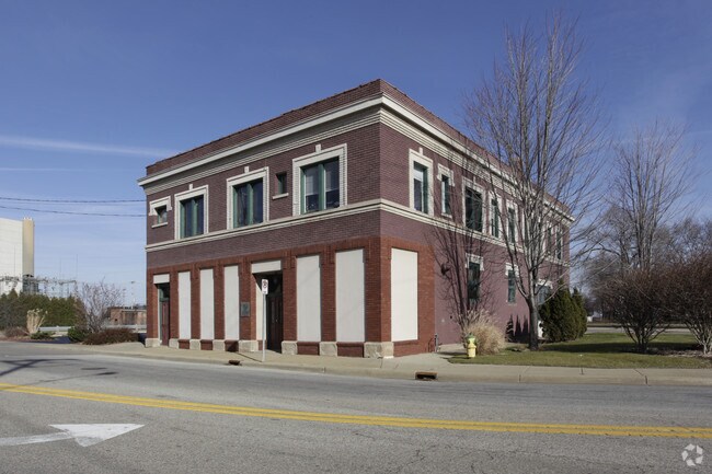
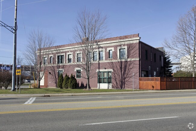
Property Record
481 Portage St, Kalamazoo, MI 49007

NEARBY LISTINGS FOR SALE OR LEASE
-
-
-
-
-
No Photo
-
-
-
View all Kalamazoo listings for sale on LoopNet.com
Property Detail
481 Portage St
06-22-208-001
City Kalamazoo
Commercialnec
6238 BEGINNING AT THE INTERSECTION OF PORTAGE STREET AND GIBSON STREET; THENCE NORTH 57 DEGREES 28 MINUTES 39 SECONDS EAST
AE
Kalamazoo
26077C0187E
Michigan
2024
0.41 AC
2025
Central Kalamazoo
000201
West Michigan
7,200 SF
Kalamazoo-Portage, MI
DEMOGRAPHICS near 481 Portage St
1 Mile
3 Mile
5 Mile
2024 Total Population
13,438
78,880
145,286
2029 Population
13,694
79,048
145,320
Pop Growth 2024-2029
+ 1.91%
+ 0.21%
+ 0.02%
Average Age
34
34
36
2024 Total Households
5,882
31,519
61,490
HH Growth 2024-2029
+ 2.09%
+ 0.24%
+ 0.02%
Median Household Inc
$35,729
$44,496
$49,168
Avg Household Size
2.10
2.20
2.20
2024 Avg HH Vehicles
1.00
2.00
2.00
Median Home Value
$108,194
$139,639
$162,651
Median Year Built
1947
1955
1968
Nearby Places
Map Layers
Map Styles
 Street
 Aerial
- Restaurants
- Banks
- Shops
- Fitness
- Groceries
PUBLIC TRANSPORTATION
COMMUTER RAIL
DRIVE
WALK
Distance
2 min
15 min
0.8 mi
AIRPORT
Kalamazoo/Battle Creek International
DRIVE
WALK
Distance
Kalamazoo/Battle Creek International
15 min
4.8 mi
Nearby Properties
Address
Land Use
TOTAL SIZE
Lot Size
Zoning
Address
Land Use
TOTAL SIZE
Lot Size
Zoning
632,218 SF
10.84 AC
M-1
Address
Land Use
TOTAL SIZE
Lot Size
Zoning
374,906 SF
16.31 AC
RM-36
Address
Land Use
TOTAL SIZE
Lot Size
Zoning
329,276 SF
43.86 AC
RM-1
Address
Land Use
TOTAL SIZE
Lot Size
Zoning
429,500 SF
2 AC
CCBD
Address
Land Use
TOTAL SIZE
Lot Size
Zoning
877,422 SF
38.18 AC
M-2
Address
Land Use
TOTAL SIZE
Lot Size
Zoning
105,046 SF
19.30 AC
RM-15
Address
Land Use
TOTAL SIZE
Lot Size
Zoning
201,940 SF
9.30 AC
RM-36
Address
Land Use
TOTAL SIZE
Lot Size
Zoning
255,452 SF
20.57 AC
Address
Land Use
TOTAL SIZE
Lot Size
Zoning
110,686 SF
9.45 AC
CCBD
Address
Land Use
TOTAL SIZE
Lot Size
Zoning
134,876 SF
16.45 AC
RM-15
Address
Land Use
TOTAL SIZE
Lot Size
Zoning
275,595 SF
0.65 AC
CCBD
Address
Land Use
TOTAL SIZE
Lot Size
Zoning
Address
Land Use
TOTAL SIZE
Lot Size
Zoning
50,826 SF
0.79 AC
CCBD
Address
Land Use
TOTAL SIZE
Lot Size
Zoning
228,368 SF
9.60 AC
PUD
Address
Land Use
TOTAL SIZE
Lot Size
Zoning
606,439 SF
34.61 AC
M-2
Address
Land Use
TOTAL SIZE
Lot Size
Zoning
274,412 SF
12.10 AC
RM-1
Address
Land Use
TOTAL SIZE
Lot Size
Zoning
99,092 SF
1.45 AC
CCBD
Address
Land Use
TOTAL SIZE
Lot Size
Zoning
98,401 SF
2.94 AC
RM-15
Address
Land Use
TOTAL SIZE
Lot Size
Zoning
110,656 SF
7.54 AC
RM-15
Address
Land Use
TOTAL SIZE
Lot Size
Zoning
171,772 SF
0.68 AC
CCBD
Address
Land Use
TOTAL SIZE
Lot Size
Zoning
49,894 SF
7.09 AC
RM-15
Address
Land Use
TOTAL SIZE
Lot Size
Zoning
232,072 SF
21.21 AC
PUD
Address
Land Use
TOTAL SIZE
Lot Size
Zoning
183,820 SF
5.24 AC
CC
Address
Land Use
TOTAL SIZE
Lot Size
Zoning
69,987 SF
8.58 AC
RM-15
Address
Land Use
TOTAL SIZE
Lot Size
Zoning
129,780 SF
0.78 AC
CCBD
Address
Land Use
TOTAL SIZE
Lot Size
Zoning
42,386 SF
1.55 AC
RM-15
Address
Land Use
TOTAL SIZE
Lot Size
Zoning
143,760 SF
10.25 AC
M-2
Address
Land Use
TOTAL SIZE
Lot Size
Zoning
9.65 AC
RM-36
Address
Land Use
TOTAL SIZE
Lot Size
Zoning
Address
Land Use
TOTAL SIZE
Lot Size
Zoning
67,831 SF
6.65 AC
PUD
The World's #1 Commercial Real Estate Marketplace
Connect with us
© 2025 CoStar Group
The information above has been obtained from sources believed reliable. While we do not doubt its accuracy we have not verified it and make no guarantee, warranty or representation about it. It is your responsibility to independently confirm its accuracy and completeness. Any projections, opinions, assumptions, or estimates used are for example only and do not represent the current or future performance of the property. The value of this transaction to you depends on tax and other factors which should be evaluated by your tax, financial, and legal advisors. You and your advisors should conduct a careful, independent investigation of the property to determine to your satisfaction the suitability of the property for your needs.