Property Record
481 Woollomes Ave, Delano, CA 93215
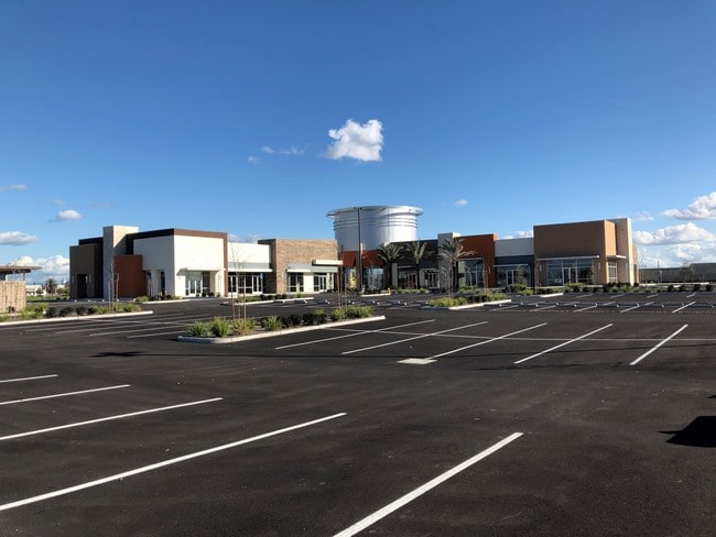

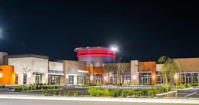

Property Detail
481 Woollomes Ave
521-260-17-00-4
PARCEL MAP 12093 , LOT 15
Regionalshoppingcenterormallwithanchorstore
Kern
CRC
California
A Areas with a 1% annual chance of flooding and a 26% chance of flooding over the life of a 30-year mortgage.
15
2024
1.57 AC
2025
NW Outlying Kern County
004802
Bakersfield
9,286 SF
Bakersfield-Delano, CA
NEARBY LISTINGS FOR SALE OR LEASE
DEMOGRAPHICS near 481 Woollomes Ave
1 mile
3 mile
5 mile
2025 Total Population
5,421
39,362
52,516
2030 Population
5,547
39,574
52,870
Pop Growth 2025-2030
+ 2.32%
+ 0.54%
+ 0.67%
Average Age
32
34
34
2025 Total Households
1,540
10,129
13,337
HH Growth 2025-2030
+ 2.21%
+ 0.63%
+ 0.73%
Median Household Inc
$60,160
$63,417
$62,889
Avg Household Size
3.50
3.80
3.80
2025 Avg HH Vehicles
2.00
2.00
2.00
Median Home Value
$347,769
$302,473
$308,968
Median Year Built
1994
1986
1987
Nearby Places
Map Layers
Map Styles
 Street
 Aerial
Layers
 Traffic
 Biking
Places
Listings with unknown addresses are not visible on the map
- Restaurants
- Banks
- Shops
- Fitness
- Groceries
PUBLIC TRANSPORTATION
AIRPORT
Meadows Field
Drive
Walk
Distance
Meadows Field
37 min
27.2 mi
Freight Ports
The Port of Hueneme
Drive
Walk
Distance
The Port of Hueneme
185 min
151.9 mi
Nearby Properties
Address
Land Use
TOTAL SIZE
Lot Size
Zoning
Address
Land Use
TOTAL SIZE
Lot Size
Zoning
33.33 AC
Address
Land Use
TOTAL SIZE
Lot Size
Zoning
22.76 AC
Address
Land Use
TOTAL SIZE
Lot Size
Zoning
51.50 AC
SP
Address
Land Use
TOTAL SIZE
Lot Size
Zoning
1,197,504 SF
80.46 AC
M1
Address
Land Use
TOTAL SIZE
Lot Size
Zoning
13,558 SF
5.53 AC
GC
Address
Land Use
TOTAL SIZE
Lot Size
Zoning
233,028 SF
11.76 AC
G-C
Address
Land Use
TOTAL SIZE
Lot Size
Zoning
190,069 SF
18 AC
CRC
Address
Land Use
TOTAL SIZE
Lot Size
Zoning
89,941 SF
11.22 AC
CRC
Address
Land Use
TOTAL SIZE
Lot Size
Zoning
80,178 SF
4.65 AC
R-3
Address
Land Use
TOTAL SIZE
Lot Size
Zoning
67,951 SF
3.42 AC
I
Address
Land Use
TOTAL SIZE
Lot Size
Zoning
87,580 SF
12 AC
A-1
Address
Land Use
TOTAL SIZE
Lot Size
Zoning
68,994 SF
4.83 AC
R-2
Address
Land Use
TOTAL SIZE
Lot Size
Zoning
3,179 SF
5.45 AC
R-3
Address
Land Use
TOTAL SIZE
Lot Size
Zoning
68,077 SF
10 AC
GC
Address
Land Use
TOTAL SIZE
Lot Size
Zoning
67,645 SF
4.71 AC
Address
Land Use
TOTAL SIZE
Lot Size
Zoning
61,600 SF
4.49 AC
R-3
Address
Land Use
TOTAL SIZE
Lot Size
Zoning
1.77 AC
Address
Land Use
TOTAL SIZE
Lot Size
Zoning
1,800 SF
4.49 AC
C1
Address
Land Use
TOTAL SIZE
Lot Size
Zoning
1.35 AC
Address
Land Use
TOTAL SIZE
Lot Size
Zoning
34,608 SF
1.59 AC
C1
Address
Land Use
TOTAL SIZE
Lot Size
Zoning
17,206 SF
2.27 AC
GC
Address
Land Use
TOTAL SIZE
Lot Size
Zoning
28,560 SF
9.51 AC
R-3
Address
Land Use
TOTAL SIZE
Lot Size
Zoning
34,064 SF
3.37 AC
GC
Address
Land Use
TOTAL SIZE
Lot Size
Zoning
84,767 SF
4.88 AC
Address
Land Use
TOTAL SIZE
Lot Size
Zoning
13,052 SF
1.77 AC
GC
Address
Land Use
TOTAL SIZE
Lot Size
Zoning
21,246 SF
0.54 AC
GC
Address
Land Use
TOTAL SIZE
Lot Size
Zoning
2.51 AC
Address
Land Use
TOTAL SIZE
Lot Size
Zoning
2.54 AC
The World's #1 Commercial Real Estate Marketplace
Connect with us
© 2026 CoStar Group
The information above has been obtained from sources believed reliable. While we do not doubt its accuracy we have not verified it and make no guarantee, warranty or representation about it. It is your responsibility to independently confirm its accuracy and completeness. Any projections, opinions, assumptions, or estimates used are for example only and do not represent the current or future performance of the property. The value of this transaction to you depends on tax and other factors which should be evaluated by your tax, financial, and legal advisors. You and your advisors should conduct a careful, independent investigation of the property to determine to your satisfaction the suitability of the property for your needs.