No Photo
Property Record
4810 Selma Hwy, Montgomery, AL 36108

NEARBY LISTINGS FOR SALE OR LEASE
Property Detail
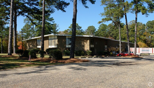
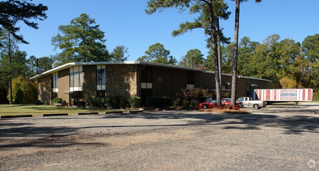
4810 Selma Hwy
Montgomery, AL
United Surgical Steel
14-03-06-1-008-017.000
1403061008017000
Publicstorage
Montgomery
X
Alabama
01001C0475E
a
0
16 AC
2025
South Montgomery
006100
Montgomery
30,357 SF
DEMOGRAPHICS near 4810 Selma Hwy
1 Mile
3 Mile
5 Mile
2024 Total Population
595
2,798
14,619
2029 Population
571
2,714
14,551
Pop Growth 2024-2029
(4.03%)
(3.00%)
(0.47%)
Average Age
43
44
41
2024 Total Households
230
1,141
5,956
HH Growth 2024-2029
(3.91%)
(2.89%)
(0.50%)
Median Household Inc
$32,976
$39,356
$29,923
Avg Household Size
2.60
2.50
2.40
2024 Avg HH Vehicles
2.00
2.00
2.00
Median Home Value
$63,740
$82,982
$78,608
Median Year Built
1971
1974
1972
Nearby Places
Map Layers
Map Styles
 Street
 Aerial
- Restaurants
- Banks
- Shops
- Fitness
- Groceries
PUBLIC TRANSPORTATION
AIRPORT
Montgomery Regional (Dannelly Field)
DRIVE
WALK
Distance
Montgomery Regional (Dannelly Field)
1 min
0.9 mi
Freight Ports
Port of Mobile
DRIVE
WALK
Distance
Port of Mobile
181 min
166.9 mi
Nearby Properties
Address
Land Use
TOTAL SIZE
Lot Size
Zoning
Address
Land Use
TOTAL SIZE
Lot Size
Zoning
263,526 SF
110.10 AC
M-1
Address
Land Use
TOTAL SIZE
Lot Size
Zoning
858,004 SF
61.22 AC
M-1
Address
Land Use
TOTAL SIZE
Lot Size
Zoning
657,684 SF
59 AC
M-1
Address
Land Use
TOTAL SIZE
Lot Size
Zoning
403,088 SF
114.39 AC
M-1
Address
Land Use
TOTAL SIZE
Lot Size
Zoning
391,901 SF
13 AC
M-3
Address
Land Use
TOTAL SIZE
Lot Size
Zoning
325,084 SF
24.51 AC
M-1
Address
Land Use
TOTAL SIZE
Lot Size
Zoning
129,122 SF
9.60 AC
M-3
Address
Land Use
TOTAL SIZE
Lot Size
Zoning
176,106 SF
19.22 AC
M-3
Address
Land Use
TOTAL SIZE
Lot Size
Zoning
146,238 SF
8.60 AC
M-1
Address
Land Use
TOTAL SIZE
Lot Size
Zoning
37,048 SF
10.90 AC
M-3
Address
Land Use
TOTAL SIZE
Lot Size
Zoning
246.64 AC
AGR-1
Address
Land Use
TOTAL SIZE
Lot Size
Zoning
87,906 SF
63 AC
M-3
Address
Land Use
TOTAL SIZE
Lot Size
Zoning
25,763 SF
4.40 AC
M-1
Address
Land Use
TOTAL SIZE
Lot Size
Zoning
48,414 SF
40 AC
Address
Land Use
TOTAL SIZE
Lot Size
Zoning
3,782 SF
165 AC
INST
Address
Land Use
TOTAL SIZE
Lot Size
Zoning
20,212 SF
20.04 AC
M-3
Address
Land Use
TOTAL SIZE
Lot Size
Zoning
44,559 SF
10 AC
M-3
Address
Land Use
TOTAL SIZE
Lot Size
Zoning
171,222 SF
38.08 AC
M-3
Address
Land Use
TOTAL SIZE
Lot Size
Zoning
29,474 SF
5.05 AC
AGR-1
Address
Land Use
TOTAL SIZE
Lot Size
Zoning
961 SF
8 AC
M-3
Address
Land Use
TOTAL SIZE
Lot Size
Zoning
61,302 SF
11.95 AC
M-1
Address
Land Use
TOTAL SIZE
Lot Size
Zoning
50,760 SF
2.86 AC
M-1
Address
Land Use
TOTAL SIZE
Lot Size
Zoning
632 AC
Address
Land Use
TOTAL SIZE
Lot Size
Zoning
1,541 SF
4.70 AC
R-75-M
Address
Land Use
TOTAL SIZE
Lot Size
Zoning
27,009 SF
20 AC
Address
Land Use
TOTAL SIZE
Lot Size
Zoning
8,750 SF
11.25 AC
Address
Land Use
TOTAL SIZE
Lot Size
Zoning
119.60 AC
M-1
Address
Land Use
TOTAL SIZE
Lot Size
Zoning
13,691 SF
2.02 AC
M-1
Address
Land Use
TOTAL SIZE
Lot Size
Zoning
11,936 SF
8.70 AC
R-100
Address
Land Use
TOTAL SIZE
Lot Size
Zoning
92,000 SF
7.70 AC
M-1
The World's #1 Commercial Real Estate Marketplace
Connect with us
© 2026 CoStar Group
The information above has been obtained from sources believed reliable. While we do not doubt its accuracy we have not verified it and make no guarantee, warranty or representation about it. It is your responsibility to independently confirm its accuracy and completeness. Any projections, opinions, assumptions, or estimates used are for example only and do not represent the current or future performance of the property. The value of this transaction to you depends on tax and other factors which should be evaluated by your tax, financial, and legal advisors. You and your advisors should conduct a careful, independent investigation of the property to determine to your satisfaction the suitability of the property for your needs.