Property Record
4810 W Mercury Blvd, Hampton, VA 23666
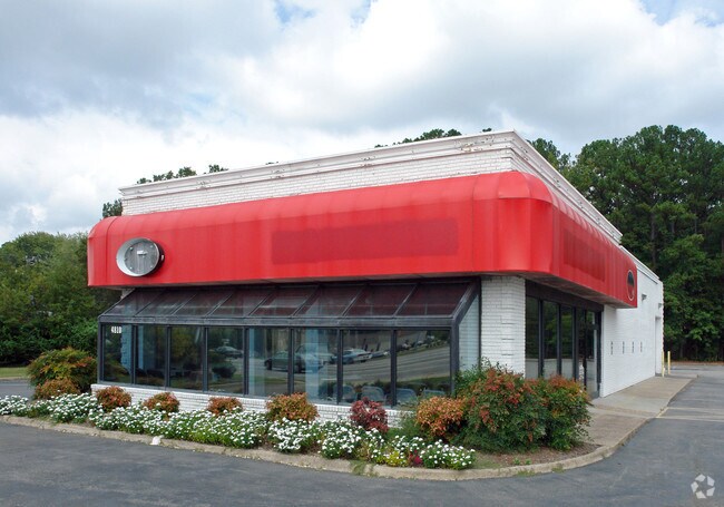


Property Detail
4810 W Mercury Blvd
3002062
MERCURY BLVD. PCA&B 1.9952AC
Storebuilding
Hampton City
14 C-2 LIM
Virginia
AE The base floodplain where base flood elevations are provided. AE Zones are now used on new format FIRMs instead of A1-A30 Zones.
2 AC
2025
Mercury Central
2025
Hampton Roads
010310
Virginia Beach-Chesapeake-Norfolk, VA-NC
3,118 SF
NEARBY LISTINGS FOR SALE OR LEASE
DEMOGRAPHICS near 4810 W Mercury Blvd
1 mile
3 mile
5 mile
2025 Total Population
14,122
79,797
162,281
2030 Population
13,934
79,282
161,310
Pop Growth 2025-2030
(1.33%)
(0.65%)
(0.60%)
Average Age
40
39
39
2025 Total Households
6,308
34,438
68,347
HH Growth 2025-2030
(1.36%)
(0.72%)
(0.69%)
Median Household Inc
$56,621
$62,358
$63,534
Avg Household Size
2.20
2.20
2.20
2025 Avg HH Vehicles
2.00
2.00
2.00
Median Home Value
$206,450
$235,588
$243,994
Median Year Built
1968
1971
1972
Nearby Places
Map Layers
Map Styles
 Street
 Aerial
Layers
 Traffic
 Biking
Places
Listings with unknown addresses are not visible on the map
- Restaurants
- Banks
- Shops
- Fitness
- Groceries
PUBLIC TRANSPORTATION
AIRPORT
Newport News/Williamsburg International
Drive
Walk
Distance
Newport News/Williamsburg International
20 min
10.0 mi
Norfolk International
Drive
Walk
Distance
Norfolk International
32 min
20.8 mi
Freight Ports
Virginia Port Authority - Newport News
Drive
Walk
Distance
Virginia Port Authority - Newport News
9 min
4.2 mi
Nearby Properties
Address
Land Use
TOTAL SIZE
Lot Size
Zoning
Address
Land Use
TOTAL SIZE
Lot Size
Zoning
1 SF
444.26 AC
M2
Address
Land Use
TOTAL SIZE
Lot Size
Zoning
347,560 SF
31.84 AC
14 C-2 LIM
Address
Land Use
TOTAL SIZE
Lot Size
Zoning
228,261 SF
48.49 AC
6 R-11 ONE
Address
Land Use
TOTAL SIZE
Lot Size
Zoning
35,550 SF
23.07 AC
14 C-2 LIM
Address
Land Use
TOTAL SIZE
Lot Size
Zoning
45,076 SF
9.53 AC
11 MD-4 MU
Address
Land Use
TOTAL SIZE
Lot Size
Zoning
13.01 AC
R7
Address
Land Use
TOTAL SIZE
Lot Size
Zoning
19,328 SF
15.14 AC
14 C-2 LIM
Address
Land Use
TOTAL SIZE
Lot Size
Zoning
540,444 SF
33.66 AC
32 M-2 LIG
Address
Land Use
TOTAL SIZE
Lot Size
Zoning
281,232 SF
17.16 AC
9 R-M MULT
Address
Land Use
TOTAL SIZE
Lot Size
Zoning
107,790 SF
5.66 AC
31 HRC-1 H
Address
Land Use
TOTAL SIZE
Lot Size
Zoning
248,956 SF
12.80 AC
14 C-2 LIM
Address
Land Use
TOTAL SIZE
Lot Size
Zoning
230,974 SF
42.68 AC
5 R-13 ONE
Address
Land Use
TOTAL SIZE
Lot Size
Zoning
88,941 SF
29.32 AC
11 MD-4 MU
Address
Land Use
TOTAL SIZE
Lot Size
Zoning
100 SF
35.50 AC
R7
Address
Land Use
TOTAL SIZE
Lot Size
Zoning
260,228 SF
37.04 AC
M1
Address
Land Use
TOTAL SIZE
Lot Size
Zoning
7,362 SF
19.76 AC
9 R-M MULT
Address
Land Use
TOTAL SIZE
Lot Size
Zoning
7,720 SF
9.91 AC
14 C-2 LIM
Address
Land Use
TOTAL SIZE
Lot Size
Zoning
100 SF
26.21 AC
R7
Address
Land Use
TOTAL SIZE
Lot Size
Zoning
286,173 SF
10 AC
14 C-2 LIM
Address
Land Use
TOTAL SIZE
Lot Size
Zoning
60,350 SF
27.53 AC
M1
Address
Land Use
TOTAL SIZE
Lot Size
Zoning
255,906 SF
36.57 AC
P1
Address
Land Use
TOTAL SIZE
Lot Size
Zoning
15,606 SF
12.07 AC
14 C-2 LIM
Address
Land Use
TOTAL SIZE
Lot Size
Zoning
34,222 SF
2.11 AC
14 C-2 LIM
Address
Land Use
TOTAL SIZE
Lot Size
Zoning
46.94 AC
39 LFA-4 L
Address
Land Use
TOTAL SIZE
Lot Size
Zoning
51,372 SF
5.99 AC
14 C-2 LIM
Address
Land Use
TOTAL SIZE
Lot Size
Zoning
458,744 SF
28.01 AC
17 M-3 HEA
Address
Land Use
TOTAL SIZE
Lot Size
Zoning
168,850 SF
1.02 AC
14 C-2 LIM
Address
Land Use
TOTAL SIZE
Lot Size
Zoning
129,400 SF
28.73 AC
P1
Address
Land Use
TOTAL SIZE
Lot Size
Zoning
123,236 SF
24.90 AC
14 C-2 LIM
Address
Land Use
TOTAL SIZE
Lot Size
Zoning
71,677 SF
18.59 AC
14 C-2 LIM
The World's #1 Commercial Real Estate Marketplace
Connect with us
© 2026 CoStar Group
The information above has been obtained from sources believed reliable. While we do not doubt its accuracy we have not verified it and make no guarantee, warranty or representation about it. It is your responsibility to independently confirm its accuracy and completeness. Any projections, opinions, assumptions, or estimates used are for example only and do not represent the current or future performance of the property. The value of this transaction to you depends on tax and other factors which should be evaluated by your tax, financial, and legal advisors. You and your advisors should conduct a careful, independent investigation of the property to determine to your satisfaction the suitability of the property for your needs.