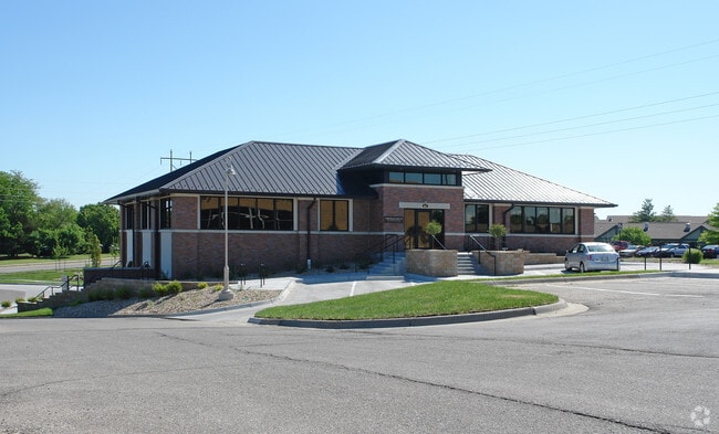
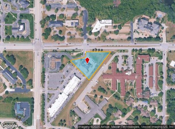
Property Record
4811 Bob Billings Pky, Lawrence, KS 66049
NEARBY LISTINGS FOR SALE OR LEASE
Property Detail
4811 Bob Billings Pky
Lawrence, KS
Subdivision 0064
023-112-04-0-10-06-003.01-0
ALVAMAR NORTHWEST NO 3 LT 1A D ESC AS:LT 1 & PART LT 3 DESC A S:BEG AT NE COR SD LT 1 TH S37 DEG44'43"W ALONG SELY LINE SD LT
Commercialofficeresidentialmixeduse
Douglas
X
Kansas
20045C0158D
1,3,d
2025
1.41 AC
2025
Lawrence
000797
Kansas City
9,086 SF
DEMOGRAPHICS near 4811 Bob Billings Pky
1 Mile
3 Mile
5 Mile
2024 Total Population
8,461
58,972
94,954
2029 Population
8,610
60,035
96,862
Pop Growth 2024-2029
+ 1.76%
+ 1.80%
+ 2.01%
Average Age
43
36
36
2024 Total Households
3,442
24,841
39,992
HH Growth 2024-2029
+ 1.83%
+ 2.00%
+ 2.20%
Median Household Inc
$108,409
$58,512
$54,876
Avg Household Size
2.40
2.20
2.20
2024 Avg HH Vehicles
2.00
2.00
2.00
Median Home Value
$399,681
$279,908
$246,984
Median Year Built
1997
1993
1988
Nearby Places
Map Layers
Map Styles
 Street
 Aerial
- Restaurants
- Banks
- Shops
- Fitness
- Groceries
PUBLIC TRANSPORTATION
COMMUTER RAIL
Lawrence Amtrak Station (Southwest Chief - Amtrak)
DRIVE
WALK
Distance
Lawrence Amtrak Station (Southwest Chief - Amtrak)
9 min
5.4 mi
Freight Ports
Tulsa Port Of Catoosa
DRIVE
WALK
Distance
Tulsa Port Of Catoosa
255 min
213.4 mi
Nearby Properties
Address
Land Use
TOTAL SIZE
Lot Size
Zoning
Address
Land Use
TOTAL SIZE
Lot Size
Zoning
1,264,810 SF
129.10 AC
RD
Address
Land Use
TOTAL SIZE
Lot Size
Zoning
243,311 SF
20.07 AC
AG
Address
Land Use
TOTAL SIZE
Lot Size
Zoning
112,168 SF
38.08 AC
RD
Address
Land Use
TOTAL SIZE
Lot Size
Zoning
200,960 SF
9.20 AC
RD
Address
Land Use
TOTAL SIZE
Lot Size
Zoning
190,168 SF
55.04 AC
C2
Address
Land Use
TOTAL SIZE
Lot Size
Zoning
336,701 SF
5.20 AC
RD
Address
Land Use
TOTAL SIZE
Lot Size
Zoning
220,557 SF
8.90 AC
RD
Address
Land Use
TOTAL SIZE
Lot Size
Zoning
143,279 SF
36.20 AC
RS1
Address
Land Use
TOTAL SIZE
Lot Size
Zoning
181,346 SF
21.40 AC
497
Address
Land Use
TOTAL SIZE
Lot Size
Zoning
186,889 SF
3.60 AC
RD
Address
Land Use
TOTAL SIZE
Lot Size
Zoning
92,295 SF
10.40 AC
RS1
Address
Land Use
TOTAL SIZE
Lot Size
Zoning
138,043 SF
26.20 AC
AG
Address
Land Use
TOTAL SIZE
Lot Size
Zoning
11,992 SF
118.15 AC
RS1
Address
Land Use
TOTAL SIZE
Lot Size
Zoning
104,785 SF
105.60 AC
RS1
Address
Land Use
TOTAL SIZE
Lot Size
Zoning
1,034 SF
254.80 AC
AG
Address
Land Use
TOTAL SIZE
Lot Size
Zoning
56,172 SF
14.05 AC
AG
Address
Land Use
TOTAL SIZE
Lot Size
Zoning
92,819 SF
3.10 AC
RO2
Address
Land Use
TOTAL SIZE
Lot Size
Zoning
55,556 SF
24.90 AC
RM1
Address
Land Use
TOTAL SIZE
Lot Size
Zoning
52,000 SF
36 AC
RS1
Address
Land Use
TOTAL SIZE
Lot Size
Zoning
19,985 SF
103.37 AC
RS1
Address
Land Use
TOTAL SIZE
Lot Size
Zoning
55,275 SF
12.30 AC
AG
Address
Land Use
TOTAL SIZE
Lot Size
Zoning
51,366 SF
15 AC
RS2
Address
Land Use
TOTAL SIZE
Lot Size
Zoning
22,774 SF
3.49 AC
RD
Address
Land Use
TOTAL SIZE
Lot Size
Zoning
40,349 SF
5.02 AC
C2
Address
Land Use
TOTAL SIZE
Lot Size
Zoning
53,678 SF
9.40 AC
RS2
Address
Land Use
TOTAL SIZE
Lot Size
Zoning
24,083 SF
3.60 AC
Address
Land Use
TOTAL SIZE
Lot Size
Zoning
54,719 SF
5.30 AC
RS2
Address
Land Use
TOTAL SIZE
Lot Size
Zoning
7,050 SF
8.05 AC
RM1
Address
Land Use
TOTAL SIZE
Lot Size
Zoning
48,077 SF
8.70 AC
RS2
Address
Land Use
TOTAL SIZE
Lot Size
Zoning
7,446 SF
4 AC
M1
The World's #1 Commercial Real Estate Marketplace
Connect with us
© 2025 CoStar Group
The information above has been obtained from sources believed reliable. While we do not doubt its accuracy we have not verified it and make no guarantee, warranty or representation about it. It is your responsibility to independently confirm its accuracy and completeness. Any projections, opinions, assumptions, or estimates used are for example only and do not represent the current or future performance of the property. The value of this transaction to you depends on tax and other factors which should be evaluated by your tax, financial, and legal advisors. You and your advisors should conduct a careful, independent investigation of the property to determine to your satisfaction the suitability of the property for your needs.