Property Record
4811 N 4Th Ave, Sioux Falls, SD 57104
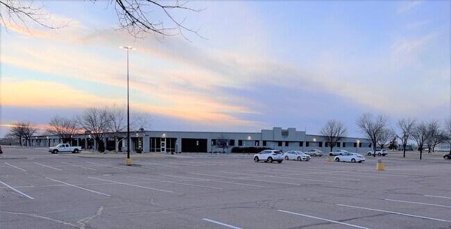

Property Detail
4811 N 4Th Ave
Sioux Falls, SD-MN
LOT 5A BLOCK 4 SIOUX EMPIRE DEVELOPMENT PARK TWO ADDN TO CITY OF SIOUX FALL
58317
Minnehaha
Officebuilding
South Dakota
NO;SPECIAL
5a
2024
9.65 AC
2024
Sioux Falls
000100
Other Market Areas
111,104 SF
NEARBY LISTINGS FOR SALE OR LEASE
DEMOGRAPHICS near 4811 N 4Th Ave
1 mile
3 mile
5 mile
2025 Total Population
263
11,929
75,265
2030 Population
261
12,472
79,265
Pop Growth 2025-2030
(0.76%)
+ 4.55%
+ 5.31%
Average Age
46
40
38
2025 Total Households
118
4,403
31,288
HH Growth 2025-2030
0.00%
+ 5.16%
+ 5.80%
Median Household Inc
$60,556
$59,933
$63,494
Avg Household Size
2.20
2.30
2.20
2025 Avg HH Vehicles
2.00
2.00
2.00
Median Home Value
$189,285
$204,545
$238,767
Median Year Built
1989
1979
1977
Nearby Places
Map Layers
Map Styles
 Street
 Aerial
Transit
 Traffic
 Biking
Places
Listings with unknown addresses are not visible on the map
- Restaurants
- Banks
- Shops
- Fitness
- Groceries
PUBLIC TRANSPORTATION
AIRPORT
Joe Foss Field
Drive
Walk
Distance
Joe Foss Field
22 min
6.0 mi
Freight Ports
Port Milwaukee
Drive
Walk
Distance
Port Milwaukee
543 min
500.5 mi
SALE & LEASE HISTORY
LISTING DATE
SALE/LEASE

Aug 02, 2023
For Sale
Nearby Properties
Address
Land Use
TOTAL SIZE
Lot Size
Zoning
Address
Land Use
TOTAL SIZE
Lot Size
Zoning
348,059 SF
32.99 AC
Address
Land Use
TOTAL SIZE
Lot Size
Zoning
14,820 SF
80.57 AC
FP;FP
Address
Land Use
TOTAL SIZE
Lot Size
Zoning
300,920 SF
90.58 AC
Address
Land Use
TOTAL SIZE
Lot Size
Zoning
41.01 AC
FP;FP
Address
Land Use
TOTAL SIZE
Lot Size
Zoning
Address
Land Use
TOTAL SIZE
Lot Size
Zoning
50,160 SF
24.88 AC
Address
Land Use
TOTAL SIZE
Lot Size
Zoning
145,014 SF
14.41 AC
Address
Land Use
TOTAL SIZE
Lot Size
Zoning
140,816 SF
13.80 AC
Address
Land Use
TOTAL SIZE
Lot Size
Zoning
35,688 SF
8.27 AC
FP;FP
Address
Land Use
TOTAL SIZE
Lot Size
Zoning
149,520 SF
22.50 AC
Address
Land Use
TOTAL SIZE
Lot Size
Zoning
173,235 SF
10 AC
Address
Land Use
TOTAL SIZE
Lot Size
Zoning
33,416 SF
9.87 AC
Address
Land Use
TOTAL SIZE
Lot Size
Zoning
146,718 SF
1.65 AC
Address
Land Use
TOTAL SIZE
Lot Size
Zoning
127,332 SF
28.18 AC
Address
Land Use
TOTAL SIZE
Lot Size
Zoning
18.37 AC
Address
Land Use
TOTAL SIZE
Lot Size
Zoning
62,856 SF
11.26 AC
Address
Land Use
TOTAL SIZE
Lot Size
Zoning
168,359 SF
9.65 AC
NO;SPECIAL
Address
Land Use
TOTAL SIZE
Lot Size
Zoning
23.87 AC
Address
Land Use
TOTAL SIZE
Lot Size
Zoning
134,102 SF
11.77 AC
Address
Land Use
TOTAL SIZE
Lot Size
Zoning
58,825 SF
20.09 AC
Address
Land Use
TOTAL SIZE
Lot Size
Zoning
53,738 SF
6.04 AC
Address
Land Use
TOTAL SIZE
Lot Size
Zoning
238,875 SF
21.92 AC
NO;SPECIAL
Address
Land Use
TOTAL SIZE
Lot Size
Zoning
127,500 SF
13.04 AC
Address
Land Use
TOTAL SIZE
Lot Size
Zoning
85,272 SF
4.83 AC
Address
Land Use
TOTAL SIZE
Lot Size
Zoning
1,806 SF
170.92 AC
FP;FP
Address
Land Use
TOTAL SIZE
Lot Size
Zoning
13.08 AC
Address
Land Use
TOTAL SIZE
Lot Size
Zoning
11.65 AC
I1;LIGHT I
Address
Land Use
TOTAL SIZE
Lot Size
Zoning
123,701 SF
7.03 AC
FP;FP
Address
Land Use
TOTAL SIZE
Lot Size
Zoning
144,152 SF
12.89 AC
Address
Land Use
TOTAL SIZE
Lot Size
Zoning
The World's #1 Commercial Real Estate Marketplace
Connect with us
© 2026 CoStar Group
The information above has been obtained from sources believed reliable. While we do not doubt its accuracy we have not verified it and make no guarantee, warranty or representation about it. It is your responsibility to independently confirm its accuracy and completeness. Any projections, opinions, assumptions, or estimates used are for example only and do not represent the current or future performance of the property. The value of this transaction to you depends on tax and other factors which should be evaluated by your tax, financial, and legal advisors. You and your advisors should conduct a careful, independent investigation of the property to determine to your satisfaction the suitability of the property for your needs.