Property Record
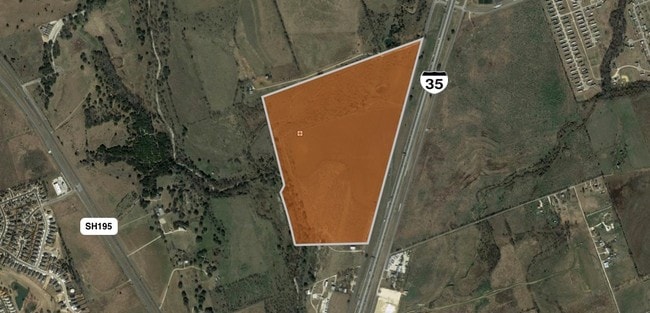
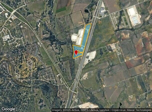
4805 N Interstate 35, Georgetown, TX 78633

NEARBY LISTINGS FOR SALE OR LEASE
Property Detail
4805 N Interstate 35
Austin-Round Rock-San Marcos, TX
Roberts, Wm. Sur.
R040508
AW0524 AW0524 - ROBERTS, WM. SUR., ACRES 51.018
Vacantlandnec
Williamson
A
Texas
48491C0285F
17
2024
51.02 AC
2025
Georgetown
021603
Austin
DEMOGRAPHICS near 4805 N Interstate 35
1 mile
3 mile
5 mile
2024 Total Population
901
9,574
45,376
2029 Population
1,147
12,113
57,665
Pop Growth 2024-2029
+ 27.30%
+ 26.52%
+ 27.08%
Average Age
41
47
48
2024 Total Households
324
3,730
19,669
HH Growth 2024-2029
+ 27.78%
+ 26.94%
+ 27.51%
Median Household Inc
$106,656
$106,201
$83,912
Avg Household Size
2.70
2.50
2.30
2024 Avg HH Vehicles
2.00
2.00
2.00
Median Home Value
$547,170
$469,198
$386,472
Median Year Built
2002
2001
2003
Nearby Places
Map Layers
Map Styles
 Street
 Aerial
Transit
 Traffic
 Biking
Places
Listings with unknown addresses are not visible on the map
- Restaurants
- Banks
- Shops
- Fitness
- Groceries
PUBLIC TRANSPORTATION
AIRPORT
Killeen Municipal
Drive
Walk
Distance
Killeen Municipal
46 min
37.1 mi
Robert Gray AAF
Drive
Walk
Distance
Robert Gray AAF
50 min
37.9 mi
Freight Ports
Calhoun Port
Drive
Walk
Distance
Calhoun Port
212 min
188.1 mi
SALE & LEASE HISTORY
LISTING DATE
SALE/LEASE

Mar 30, 2018
For Sale
Aug 25, 2017
For Sale
Aug 07, 2017
For Sale
Apr 21, 2017
For Sale
Nearby Properties
Address
Land Use
TOTAL SIZE
Lot Size
Zoning
Address
Land Use
TOTAL SIZE
Lot Size
Zoning
200,200 SF
34.02 AC
Address
Land Use
TOTAL SIZE
Lot Size
Zoning
453,015 SF
22.62 AC
Address
Land Use
TOTAL SIZE
Lot Size
Zoning
326,646 SF
19.33 AC
Address
Land Use
TOTAL SIZE
Lot Size
Zoning
425,144 SF
32.97 AC
Address
Land Use
TOTAL SIZE
Lot Size
Zoning
439,044 SF
32.68 AC
Address
Land Use
TOTAL SIZE
Lot Size
Zoning
495,945 SF
56.14 AC
Address
Land Use
TOTAL SIZE
Lot Size
Zoning
520,121 SF
56.73 AC
Address
Land Use
TOTAL SIZE
Lot Size
Zoning
193,985 SF
38.17 AC
Address
Land Use
TOTAL SIZE
Lot Size
Zoning
298,302 SF
20.96 AC
Address
Land Use
TOTAL SIZE
Lot Size
Zoning
241,857 SF
26.60 AC
Address
Land Use
TOTAL SIZE
Lot Size
Zoning
200,746 SF
17.52 AC
Address
Land Use
TOTAL SIZE
Lot Size
Zoning
232,368 SF
16.40 AC
Address
Land Use
TOTAL SIZE
Lot Size
Zoning
154,603 SF
20.04 AC
Address
Land Use
TOTAL SIZE
Lot Size
Zoning
172,657 SF
8.84 AC
Address
Land Use
TOTAL SIZE
Lot Size
Zoning
174,955 SF
9.28 AC
Address
Land Use
TOTAL SIZE
Lot Size
Zoning
162,236 SF
8.99 AC
Address
Land Use
TOTAL SIZE
Lot Size
Zoning
90,821 SF
41.97 AC
Address
Land Use
TOTAL SIZE
Lot Size
Zoning
160,042 SF
10.15 AC
Address
Land Use
TOTAL SIZE
Lot Size
Zoning
184,242 SF
11 AC
Address
Land Use
TOTAL SIZE
Lot Size
Zoning
219,839 SF
24.74 AC
Address
Land Use
TOTAL SIZE
Lot Size
Zoning
22,936 SF
111.18 AC
Address
Land Use
TOTAL SIZE
Lot Size
Zoning
150,808 SF
7.72 AC
2-I
Address
Land Use
TOTAL SIZE
Lot Size
Zoning
100,956 SF
5.32 AC
Address
Land Use
TOTAL SIZE
Lot Size
Zoning
124,292 SF
8.67 AC
Address
Land Use
TOTAL SIZE
Lot Size
Zoning
70,873 SF
5.88 AC
Address
Land Use
TOTAL SIZE
Lot Size
Zoning
62,452 SF
11 AC
Address
Land Use
TOTAL SIZE
Lot Size
Zoning
57,600 SF
4.12 AC
Address
Land Use
TOTAL SIZE
Lot Size
Zoning
39,020 SF
11.65 AC
Address
Land Use
TOTAL SIZE
Lot Size
Zoning
57,600 SF
7.20 AC
Address
Land Use
TOTAL SIZE
Lot Size
Zoning
58,763 SF
4.24 AC
2-I
The World's #1 Commercial Real Estate Marketplace
Connect with us
© 2026 CoStar Group
The information above has been obtained from sources believed reliable. While we do not doubt its accuracy we have not verified it and make no guarantee, warranty or representation about it. It is your responsibility to independently confirm its accuracy and completeness. Any projections, opinions, assumptions, or estimates used are for example only and do not represent the current or future performance of the property. The value of this transaction to you depends on tax and other factors which should be evaluated by your tax, financial, and legal advisors. You and your advisors should conduct a careful, independent investigation of the property to determine to your satisfaction the suitability of the property for your needs.