Property Record
4811 N Interstate 35, Georgetown, TX 78633
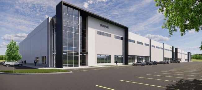
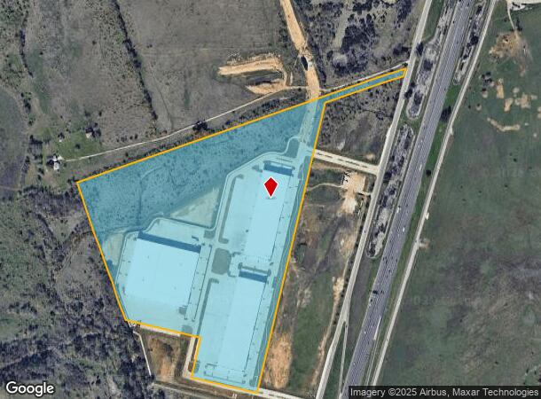
Property Detail
4811 N Interstate 35
Austin-Round Rock-San Marcos, TX
S12952 - JACKSON SHAW GEORGETOWN PH 1, BLOCK A, LOT 2, ACRES 56.137
R629214
WILLIAMSON
Industrialgeneral
Texas
2024
2
2025
56.14 AC
021603
Georgetown
495,945 SF
Austin
NEARBY LISTINGS FOR SALE OR LEASE
DEMOGRAPHICS near 4811 N Interstate 35
1 mile
3 mile
5 mile
2025 Total Population
598
8,744
43,121
2030 Population
681
9,993
49,292
Pop Growth 2025-2030
+ 13.88%
+ 14.28%
+ 14.31%
Average Age
39
47
48
2025 Total Households
202
3,467
18,742
HH Growth 2025-2030
+ 14.85%
+ 14.68%
+ 14.60%
Median Household Inc
$119,270
$116,353
$94,654
Avg Household Size
2.90
2.50
2.30
2025 Avg HH Vehicles
2.00
2.00
2.00
Median Home Value
$815,217
$544,366
$453,354
Median Year Built
1999
2003
2004
Nearby Places
Map Layers
Map Styles
 Street
 Aerial
Transit
 Traffic
 Biking
Places
Listings with unknown addresses are not visible on the map
- Restaurants
- Banks
- Shops
- Fitness
- Groceries
PUBLIC TRANSPORTATION
AIRPORT
Killeen Municipal
Drive
Walk
Distance
Killeen Municipal
48 min
37.6 mi
Robert Gray AAF
Drive
Walk
Distance
Robert Gray AAF
52 min
38.4 mi
Nearby Properties
Address
Land Use
TOTAL SIZE
Lot Size
Zoning
Address
Land Use
TOTAL SIZE
Lot Size
Zoning
200,200 SF
34.02 AC
Address
Land Use
TOTAL SIZE
Lot Size
Zoning
326,646 SF
19.33 AC
Address
Land Use
TOTAL SIZE
Lot Size
Zoning
425,144 SF
32.97 AC
Address
Land Use
TOTAL SIZE
Lot Size
Zoning
439,044 SF
32.68 AC
Address
Land Use
TOTAL SIZE
Lot Size
Zoning
405,439 SF
24.33 AC
Address
Land Use
TOTAL SIZE
Lot Size
Zoning
520,121 SF
56.73 AC
Address
Land Use
TOTAL SIZE
Lot Size
Zoning
193,985 SF
38.17 AC
Address
Land Use
TOTAL SIZE
Lot Size
Zoning
298,302 SF
20.96 AC
Address
Land Use
TOTAL SIZE
Lot Size
Zoning
200,746 SF
17.52 AC
Address
Land Use
TOTAL SIZE
Lot Size
Zoning
172,657 SF
8.84 AC
Address
Land Use
TOTAL SIZE
Lot Size
Zoning
174,955 SF
9.28 AC
Address
Land Use
TOTAL SIZE
Lot Size
Zoning
160,042 SF
10.15 AC
Address
Land Use
TOTAL SIZE
Lot Size
Zoning
184,242 SF
11 AC
Address
Land Use
TOTAL SIZE
Lot Size
Zoning
219,839 SF
24.74 AC
Address
Land Use
TOTAL SIZE
Lot Size
Zoning
22,936 SF
111.18 AC
Address
Land Use
TOTAL SIZE
Lot Size
Zoning
150,808 SF
7.72 AC
2-I
Address
Land Use
TOTAL SIZE
Lot Size
Zoning
100,956 SF
5.32 AC
Address
Land Use
TOTAL SIZE
Lot Size
Zoning
124,292 SF
8.67 AC
Address
Land Use
TOTAL SIZE
Lot Size
Zoning
70,873 SF
5.88 AC
Address
Land Use
TOTAL SIZE
Lot Size
Zoning
109,788 SF
17.45 AC
Address
Land Use
TOTAL SIZE
Lot Size
Zoning
62,452 SF
11 AC
Address
Land Use
TOTAL SIZE
Lot Size
Zoning
57,600 SF
4.12 AC
Address
Land Use
TOTAL SIZE
Lot Size
Zoning
39,020 SF
11.65 AC
Address
Land Use
TOTAL SIZE
Lot Size
Zoning
57,600 SF
7.20 AC
Address
Land Use
TOTAL SIZE
Lot Size
Zoning
58,763 SF
4.24 AC
2-I
Address
Land Use
TOTAL SIZE
Lot Size
Zoning
84,960 SF
5.12 AC
Address
Land Use
TOTAL SIZE
Lot Size
Zoning
26,306 SF
10.03 AC
Address
Land Use
TOTAL SIZE
Lot Size
Zoning
31,480 SF
19.73 AC
Address
Land Use
TOTAL SIZE
Lot Size
Zoning
43,000 SF
4.47 AC
The World's #1 Commercial Real Estate Marketplace
Connect with us
© 2026 CoStar Group
The information above has been obtained from sources believed reliable. While we do not doubt its accuracy we have not verified it and make no guarantee, warranty or representation about it. It is your responsibility to independently confirm its accuracy and completeness. Any projections, opinions, assumptions, or estimates used are for example only and do not represent the current or future performance of the property. The value of this transaction to you depends on tax and other factors which should be evaluated by your tax, financial, and legal advisors. You and your advisors should conduct a careful, independent investigation of the property to determine to your satisfaction the suitability of the property for your needs.