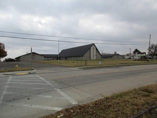
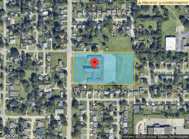
Property Record
4811 S 25Th Pl W, Tulsa, OK 74107
NEARBY LISTINGS FOR SALE OR LEASE
-
-
View all Tulsa listings for sale on LoopNet.com
Property Detail
4811 S 25Th Pl W
99227-92-27-28460
Unplatted
Religious
N330 W/2 SW SE LESS W30 FOR ST SEC 27 19 12 4.773ACS
X
Tulsa
40143C0334L
Oklahoma
0
4.77 AC
2025
West
004700
Tulsa
25,088 SF
Tulsa, OK
DEMOGRAPHICS near 4811 S 25Th Pl W
1 Mile
3 Mile
5 Mile
2024 Total Population
7,097
40,381
125,021
2029 Population
7,354
41,790
129,971
Pop Growth 2024-2029
+ 3.62%
+ 3.49%
+ 3.96%
Average Age
38
39
40
2024 Total Households
2,835
18,014
56,390
HH Growth 2024-2029
+ 3.67%
+ 3.47%
+ 4.10%
Median Household Inc
$46,078
$49,312
$54,392
Avg Household Size
2.40
2.20
2.10
2024 Avg HH Vehicles
2.00
2.00
2.00
Median Home Value
$82,708
$155,415
$226,793
Median Year Built
1956
1969
1969
Nearby Places
Map Layers
Map Styles
 Street
 Aerial
- Restaurants
- Banks
- Shops
- Fitness
- Groceries
PUBLIC TRANSPORTATION
AIRPORT
Tulsa International
DRIVE
WALK
Distance
Tulsa International
23 min
14.2 mi
Freight Ports
Tulsa Port Of Catoosa
DRIVE
WALK
Distance
Tulsa Port Of Catoosa
32 min
23.4 mi
SALE & LEASE HISTORY
LISTING DATE
SALE/LEASE

Jan 14, 2018
For Sale
Nearby Properties
Address
Land Use
TOTAL SIZE
Lot Size
Zoning
Address
Land Use
TOTAL SIZE
Lot Size
Zoning
1,134,776 SF
35.85 AC
CN
Address
Land Use
TOTAL SIZE
Lot Size
Zoning
49,992 SF
33.23 AC
AG
Address
Land Use
TOTAL SIZE
Lot Size
Zoning
290,963 SF
10.77 AC
RM1
Address
Land Use
TOTAL SIZE
Lot Size
Zoning
119,056 SF
28.06 AC
CM
Address
Land Use
TOTAL SIZE
Lot Size
Zoning
88,702 SF
8.27 AC
IM
Address
Land Use
TOTAL SIZE
Lot Size
Zoning
21,693 SF
4.24 AC
Address
Land Use
TOTAL SIZE
Lot Size
Zoning
106,743 SF
4.34 AC
MX1U55
Address
Land Use
TOTAL SIZE
Lot Size
Zoning
89,640 SF
5.47 AC
MX1U55
Address
Land Use
TOTAL SIZE
Lot Size
Zoning
100,857 SF
4.04 AC
MX1U55
Address
Land Use
TOTAL SIZE
Lot Size
Zoning
132,105 SF
9.32 AC
RS3
Address
Land Use
TOTAL SIZE
Lot Size
Zoning
78,442 SF
31.24 AC
IM
Address
Land Use
TOTAL SIZE
Lot Size
Zoning
53,220 SF
4.93 AC
CH
Address
Land Use
TOTAL SIZE
Lot Size
Zoning
330,521 SF
22.04 AC
PUD
Address
Land Use
TOTAL SIZE
Lot Size
Zoning
84,791 SF
8.04 AC
RS3
Address
Land Use
TOTAL SIZE
Lot Size
Zoning
1,123,266 SF
87.29 AC
IM
Address
Land Use
TOTAL SIZE
Lot Size
Zoning
110,382 SF
9.81 AC
RS3
Address
Land Use
TOTAL SIZE
Lot Size
Zoning
35,845 SF
14.38 AC
CS
Address
Land Use
TOTAL SIZE
Lot Size
Zoning
394,728 SF
5.44 AC
CH
Address
Land Use
TOTAL SIZE
Lot Size
Zoning
102,070 SF
6.92 AC
IM
Address
Land Use
TOTAL SIZE
Lot Size
Zoning
198 SF
19.81 AC
RS3
Address
Land Use
TOTAL SIZE
Lot Size
Zoning
270,584 SF
28.85 AC
CO
Address
Land Use
TOTAL SIZE
Lot Size
Zoning
432 SF
72.60 AC
AG
Address
Land Use
TOTAL SIZE
Lot Size
Zoning
6,162 SF
4.25 AC
CH
Address
Land Use
TOTAL SIZE
Lot Size
Zoning
72,690 SF
8.04 AC
RS3
Address
Land Use
TOTAL SIZE
Lot Size
Zoning
27,225 SF
2.19 AC
MX1U55
Address
Land Use
TOTAL SIZE
Lot Size
Zoning
143,520 SF
25.14 AC
IM
Address
Land Use
TOTAL SIZE
Lot Size
Zoning
82,843 SF
4.10 AC
RS3
Address
Land Use
TOTAL SIZE
Lot Size
Zoning
47,670 SF
10.05 AC
RS
Address
Land Use
TOTAL SIZE
Lot Size
Zoning
50,109 SF
28.71 AC
NCU
Address
Land Use
TOTAL SIZE
Lot Size
Zoning
32,847 SF
28.03 AC
RS3
The World's #1 Commercial Real Estate Marketplace
Connect with us
© 2026 CoStar Group
The information above has been obtained from sources believed reliable. While we do not doubt its accuracy we have not verified it and make no guarantee, warranty or representation about it. It is your responsibility to independently confirm its accuracy and completeness. Any projections, opinions, assumptions, or estimates used are for example only and do not represent the current or future performance of the property. The value of this transaction to you depends on tax and other factors which should be evaluated by your tax, financial, and legal advisors. You and your advisors should conduct a careful, independent investigation of the property to determine to your satisfaction the suitability of the property for your needs.