Property Record
4812 Hartfield Rd, Round Top, TX 78954

Property Detail
4812 Hartfield Rd
R39696
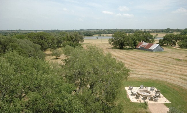
ABS A092 SHAW J LG,159.642 ACRES,HSE, GAR, FARM BLDGS
Farms
FAYETTE
A Areas with a 1% annual chance of flooding and a 26% chance of flooding over the life of a 30-year mortgage.
Texas
2025
159.64 AC
2025
Central Texas Area
970100
Other Market Areas
1,408 SF
NEARBY LISTINGS FOR SALE OR LEASE
-
-
View all Round Top listings for sale on LoopNet.com
DEMOGRAPHICS near 4812 Hartfield Rd
1 mile
3 mile
5 mile
2025 Total Population
30
409
1,330
2030 Population
31
429
1,396
Pop Growth 2025-2030
+ 3.33%
+ 4.89%
+ 4.96%
Average Age
51
52
52
2025 Total Households
14
194
624
HH Growth 2025-2030
+ 7.14%
+ 4.64%
+ 4.81%
Median Household Inc
$87,500
$85,344
$86,773
Avg Household Size
2.20
2.10
2.10
2025 Avg HH Vehicles
3.00
3.00
3.00
Median Home Value
$350,000
$409,615
$431,927
Median Year Built
1982
1985
1988
Nearby Places
Map Layers
Map Styles
 Street
 Aerial
Transit
 Traffic
 Biking
Places
Listings with unknown addresses are not visible on the map
- Restaurants
- Banks
- Shops
- Fitness
- Groceries
Nearby Properties
Address
Land Use
TOTAL SIZE
Lot Size
Zoning
Address
Land Use
TOTAL SIZE
Lot Size
Zoning
5,223 SF
202.78 AC
Address
Land Use
TOTAL SIZE
Lot Size
Zoning
21,177 SF
513.52 AC
Address
Land Use
TOTAL SIZE
Lot Size
Zoning
4,444 SF
96.86 AC
Address
Land Use
TOTAL SIZE
Lot Size
Zoning
2,158 SF
85.28 AC
Address
Land Use
TOTAL SIZE
Lot Size
Zoning
3,578 SF
101.25 AC
Address
Land Use
TOTAL SIZE
Lot Size
Zoning
90 AC
Address
Land Use
TOTAL SIZE
Lot Size
Zoning
1,630 SF
72.55 AC
Address
Land Use
TOTAL SIZE
Lot Size
Zoning
7,732 SF
684.25 AC
Address
Land Use
TOTAL SIZE
Lot Size
Zoning
4,148 SF
57.22 AC
Address
Land Use
TOTAL SIZE
Lot Size
Zoning
7,104 SF
54.02 AC
Address
Land Use
TOTAL SIZE
Lot Size
Zoning
1,462 SF
59 AC
Address
Land Use
TOTAL SIZE
Lot Size
Zoning
1,144 SF
57.39 AC
Address
Land Use
TOTAL SIZE
Lot Size
Zoning
Address
Land Use
TOTAL SIZE
Lot Size
Zoning
3,641 SF
46.52 AC
Address
Land Use
TOTAL SIZE
Lot Size
Zoning
960 SF
445.34 AC
Address
Land Use
TOTAL SIZE
Lot Size
Zoning
4,853 SF
53.86 AC
Address
Land Use
TOTAL SIZE
Lot Size
Zoning
1,008 SF
50.29 AC
Address
Land Use
TOTAL SIZE
Lot Size
Zoning
2,481 SF
45 AC
Address
Land Use
TOTAL SIZE
Lot Size
Zoning
1,052 SF
315.84 AC
Address
Land Use
TOTAL SIZE
Lot Size
Zoning
4,864 SF
36.91 AC
Address
Land Use
TOTAL SIZE
Lot Size
Zoning
57.50 AC
Address
Land Use
TOTAL SIZE
Lot Size
Zoning
5,849 SF
32.87 AC
Address
Land Use
TOTAL SIZE
Lot Size
Zoning
32,402 SF
314.33 AC
Address
Land Use
TOTAL SIZE
Lot Size
Zoning
53.44 AC
Address
Land Use
TOTAL SIZE
Lot Size
Zoning
1,638 SF
39.24 AC
Address
Land Use
TOTAL SIZE
Lot Size
Zoning
1,740 SF
48 AC
Address
Land Use
TOTAL SIZE
Lot Size
Zoning
2,748 SF
35.54 AC
Address
Land Use
TOTAL SIZE
Lot Size
Zoning
4,509 SF
33.11 AC
Address
Land Use
TOTAL SIZE
Lot Size
Zoning
66.58 AC
Address
Land Use
TOTAL SIZE
Lot Size
Zoning
1,127 SF
39.94 AC
The World's #1 Commercial Real Estate Marketplace
Connect with us
© 2026 CoStar Group
The information above has been obtained from sources believed reliable. While we do not doubt its accuracy we have not verified it and make no guarantee, warranty or representation about it. It is your responsibility to independently confirm its accuracy and completeness. Any projections, opinions, assumptions, or estimates used are for example only and do not represent the current or future performance of the property. The value of this transaction to you depends on tax and other factors which should be evaluated by your tax, financial, and legal advisors. You and your advisors should conduct a careful, independent investigation of the property to determine to your satisfaction the suitability of the property for your needs.