Property Record
Unassigned Address, Spokane, WA 99224

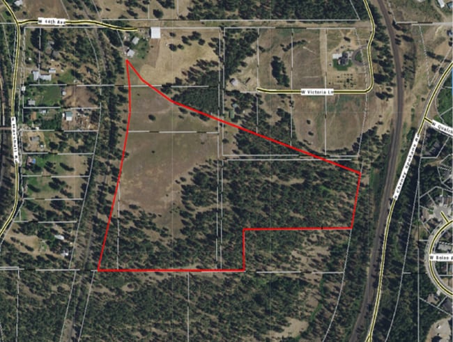
This Property Is For Sale
NEARBY LISTINGS FOR SALE OR LEASE
Property Detail
Unassigned Address
Spokane-Spokane Valley, WA
Spring Grove
24011.0104
SPRING GROVE ALL L9TO12 ;LESS R/W L13-14
Railroadfacility
Spokane
X
Washington
53063C0702D
13-14
2025
15.72 AC
2025
South Hill
0135002059
Spokane
DEMOGRAPHICS near Unassigned Address
1 Mile
3 Mile
5 Mile
2024 Total Population
1,963
46,203
129,882
2029 Population
2,096
49,338
138,659
Pop Growth 2024-2029
+ 6.78%
+ 6.79%
+ 6.76%
Average Age
40
42
40
2024 Total Households
718
20,401
55,555
HH Growth 2024-2029
+ 6.96%
+ 7.08%
+ 7.15%
Median Household Inc
$126,118
$75,662
$63,360
Avg Household Size
2.70
2.20
2.20
2024 Avg HH Vehicles
2.00
2.00
2.00
Median Home Value
$513,281
$448,178
$398,551
Median Year Built
2007
1969
1972
Nearby Places
Map Layers
Map Styles
 Street
 Aerial
- Restaurants
- Banks
- Shops
- Fitness
- Groceries
PUBLIC TRANSPORTATION
COMMUTER RAIL
Spokane (Empire Builder - Amtrak)
DRIVE
WALK
Distance
Spokane (Empire Builder - Amtrak)
14 min
6.2 mi
AIRPORT
Spokane International
DRIVE
WALK
Distance
Spokane International
17 min
8.4 mi
Freight Ports
Port of Everett
DRIVE
WALK
Distance
Port of Everett
345 min
303.9 mi
Nearby Properties
Address
Land Use
TOTAL SIZE
Lot Size
Zoning
Address
Land Use
TOTAL SIZE
Lot Size
Zoning
763,627 SF
12.44 AC
OR
Address
Land Use
TOTAL SIZE
Lot Size
Zoning
91,882 SF
2.07 AC
OR
Address
Land Use
TOTAL SIZE
Lot Size
Zoning
124,234 SF
13.54 AC
RSF
Address
Land Use
TOTAL SIZE
Lot Size
Zoning
289,705 SF
3.36 AC
OR
Address
Land Use
TOTAL SIZE
Lot Size
Zoning
289,573 SF
7.73 AC
RMF
Address
Land Use
TOTAL SIZE
Lot Size
Zoning
197,933 SF
37.51 AC
UR
Address
Land Use
TOTAL SIZE
Lot Size
Zoning
303,597 SF
62.39 AC
LDR
Address
Land Use
TOTAL SIZE
Lot Size
Zoning
236,105 SF
5.01 AC
OR
Address
Land Use
TOTAL SIZE
Lot Size
Zoning
177,707 SF
44.44 AC
LI
Address
Land Use
TOTAL SIZE
Lot Size
Zoning
177,044 SF
14.71 AC
LDR
Address
Land Use
TOTAL SIZE
Lot Size
Zoning
78,990 SF
5.58 AC
RSF
Address
Land Use
TOTAL SIZE
Lot Size
Zoning
79,200 SF
OR
Address
Land Use
TOTAL SIZE
Lot Size
Zoning
59,826 SF
6.79 AC
RSF
Address
Land Use
TOTAL SIZE
Lot Size
Zoning
18,850 SF
0.64 AC
OR
Address
Land Use
TOTAL SIZE
Lot Size
Zoning
80,076 SF
0.49 AC
OR
Address
Land Use
TOTAL SIZE
Lot Size
Zoning
29,160 SF
0.34 AC
OR
Address
Land Use
TOTAL SIZE
Lot Size
Zoning
165,672 SF
1.06 AC
OR
Address
Land Use
TOTAL SIZE
Lot Size
Zoning
117,668 SF
7.52 AC
CC2
Address
Land Use
TOTAL SIZE
Lot Size
Zoning
48,003 SF
1.72 AC
RSF
Address
Land Use
TOTAL SIZE
Lot Size
Zoning
89,251 SF
0.52 AC
OR
Address
Land Use
TOTAL SIZE
Lot Size
Zoning
138,756 SF
1.21 AC
OR
Address
Land Use
TOTAL SIZE
Lot Size
Zoning
82,519 SF
1.86 AC
RHD
Address
Land Use
TOTAL SIZE
Lot Size
Zoning
64,956 SF
4.69 AC
HDR
Address
Land Use
TOTAL SIZE
Lot Size
Zoning
101,415 SF
1.23 AC
RHD
Address
Land Use
TOTAL SIZE
Lot Size
Zoning
56,000 SF
2.49 AC
RHD
Address
Land Use
TOTAL SIZE
Lot Size
Zoning
44,703 SF
0.86 AC
OR
Address
Land Use
TOTAL SIZE
Lot Size
Zoning
156,190 SF
13.89 AC
LI
Address
Land Use
TOTAL SIZE
Lot Size
Zoning
46,696 SF
30.75 AC
LI
Address
Land Use
TOTAL SIZE
Lot Size
Zoning
17,331 SF
3.26 AC
GC
Address
Land Use
TOTAL SIZE
Lot Size
Zoning
101,172 SF
10 AC
LI
The World's #1 Commercial Real Estate Marketplace
Connect with us
© 2025 CoStar Group
The information above has been obtained from sources believed reliable. While we do not doubt its accuracy we have not verified it and make no guarantee, warranty or representation about it. It is your responsibility to independently confirm its accuracy and completeness. Any projections, opinions, assumptions, or estimates used are for example only and do not represent the current or future performance of the property. The value of this transaction to you depends on tax and other factors which should be evaluated by your tax, financial, and legal advisors. You and your advisors should conduct a careful, independent investigation of the property to determine to your satisfaction the suitability of the property for your needs.