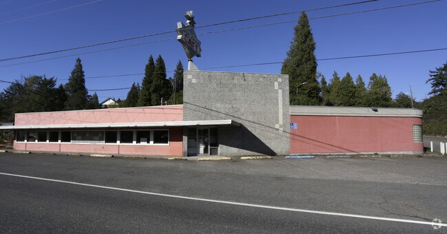
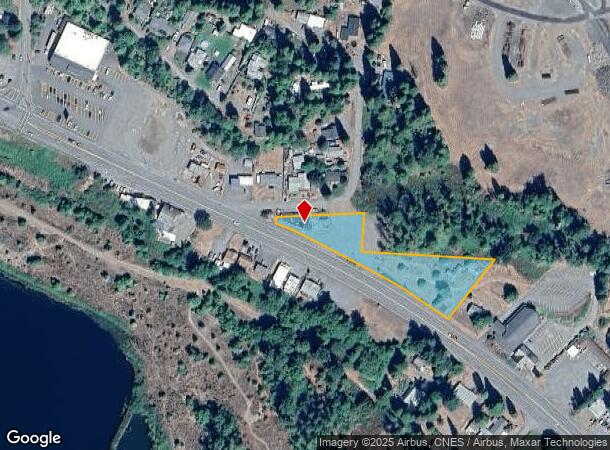
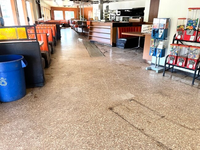
Property Record
48127 Highway 58, Oakridge, OR 97463

NEARBY LISTINGS FOR SALE OR LEASE
-
-
View all Oakridge listings for sale on LoopNet.com
Property Detail
48127 Highway 58
Eugene, OR
Forest Add/Oakridge
0955029
TL 04700
Commercialbuilding
Lane
X
Oregon
41039C2477F
4700
2025
1.31 AC
2025
Lane County
001500
Portland
DEMOGRAPHICS near 48127 Highway 58
1 Mile
3 Mile
5 Mile
2024 Total Population
2,798
4,520
5,114
2029 Population
2,857
4,619
5,227
Pop Growth 2024-2029
+ 2.11%
+ 2.19%
+ 2.21%
Average Age
46
46
46
2024 Total Households
1,287
2,037
2,277
HH Growth 2024-2029
+ 2.10%
+ 2.11%
+ 2.15%
Median Household Inc
$34,505
$34,956
$35,182
Avg Household Size
2.20
2.20
2.20
2024 Avg HH Vehicles
2.00
2.00
2.00
Median Home Value
$141,008
$165,982
$182,492
Median Year Built
1961
1966
1966
Nearby Places
- Restaurants
- Banks
- Shops
- Fitness
- Groceries
SALE & LEASE HISTORY
LISTING DATE
SALE/LEASE

Oct 19, 2017
For Sale
May 14, 2023
For Sale
Nearby Properties
Address
Land Use
TOTAL SIZE
Lot Size
Zoning
Address
Land Use
TOTAL SIZE
Lot Size
Zoning
5.58 AC
R1
Address
Land Use
TOTAL SIZE
Lot Size
Zoning
5,615.58 AC
F1
Address
Land Use
TOTAL SIZE
Lot Size
Zoning
248.60 AC
C3
Address
Land Use
TOTAL SIZE
Lot Size
Zoning
2.85 AC
F2
Address
Land Use
TOTAL SIZE
Lot Size
Zoning
4,081.10 AC
E40
Address
Land Use
TOTAL SIZE
Lot Size
Zoning
1.24 AC
C3
Address
Land Use
TOTAL SIZE
Lot Size
Zoning
2.09 AC
C3
Address
Land Use
TOTAL SIZE
Lot Size
Zoning
0.95 AC
C3
Address
Land Use
TOTAL SIZE
Lot Size
Zoning
0.61 AC
C3
Address
Land Use
TOTAL SIZE
Lot Size
Zoning
0.80 AC
C3
Address
Land Use
TOTAL SIZE
Lot Size
Zoning
0.95 AC
C3
Address
Land Use
TOTAL SIZE
Lot Size
Zoning
5.11 AC
R1
Address
Land Use
TOTAL SIZE
Lot Size
Zoning
39.24 AC
F2
Address
Land Use
TOTAL SIZE
Lot Size
Zoning
0.73 AC
R1
Address
Land Use
TOTAL SIZE
Lot Size
Zoning
4.89 AC
R1
Address
Land Use
TOTAL SIZE
Lot Size
Zoning
0.73 AC
C3
Address
Land Use
TOTAL SIZE
Lot Size
Zoning
0.64 AC
C2
Address
Land Use
TOTAL SIZE
Lot Size
Zoning
1.19 AC
C3
Address
Land Use
TOTAL SIZE
Lot Size
Zoning
91.20 AC
PR
Address
Land Use
TOTAL SIZE
Lot Size
Zoning
0.54 AC
C3
Address
Land Use
TOTAL SIZE
Lot Size
Zoning
6.12 AC
I2
Address
Land Use
TOTAL SIZE
Lot Size
Zoning
956.81 AC
F1
Address
Land Use
TOTAL SIZE
Lot Size
Zoning
4.48 AC
I1
Address
Land Use
TOTAL SIZE
Lot Size
Zoning
1.27 AC
R1
Address
Land Use
TOTAL SIZE
Lot Size
Zoning
3.07 AC
C3
Address
Land Use
TOTAL SIZE
Lot Size
Zoning
0.36 AC
F2
Address
Land Use
TOTAL SIZE
Lot Size
Zoning
0.79 AC
C3
Address
Land Use
TOTAL SIZE
Lot Size
Zoning
810 SF
1 AC
C3
Address
Land Use
TOTAL SIZE
Lot Size
Zoning
0.91 AC
C3
Address
Land Use
TOTAL SIZE
Lot Size
Zoning
858 SF
4.15 AC
I1
The World's #1 Commercial Real Estate Marketplace
Connect with us
© 2025 CoStar Group
The information above has been obtained from sources believed reliable. While we do not doubt its accuracy we have not verified it and make no guarantee, warranty or representation about it. It is your responsibility to independently confirm its accuracy and completeness. Any projections, opinions, assumptions, or estimates used are for example only and do not represent the current or future performance of the property. The value of this transaction to you depends on tax and other factors which should be evaluated by your tax, financial, and legal advisors. You and your advisors should conduct a careful, independent investigation of the property to determine to your satisfaction the suitability of the property for your needs.