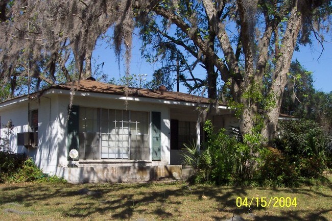
Property Record
4815 La Roche Ave, Savannah, GA 31404


NEARBY LISTINGS FOR SALE OR LEASE
Property Detail
4815 La Roche Ave
Savannah, GA
Placentia
2012001028
TCT 150 X 68 X 77 X 96 X 198 BEI NG PT OF LT 9 PLACENTIA TCT
Officebuilding
Chatham
X
Georgia
45053C0550D
9
2023
0.59 AC
2025
Greater Savannah
003800
Savannah
1,302 SF
DEMOGRAPHICS near 4815 La Roche Ave
1 Mile
3 Mile
5 Mile
2024 Total Population
10,788
69,193
134,796
2029 Population
11,099
71,512
140,304
Pop Growth 2024-2029
+ 2.88%
+ 3.35%
+ 4.09%
Average Age
38
40
39
2024 Total Households
3,520
28,277
55,496
HH Growth 2024-2029
+ 3.07%
+ 3.51%
+ 4.34%
Median Household Inc
$55,695
$55,549
$54,214
Avg Household Size
2.40
2.30
2.20
2024 Avg HH Vehicles
2.00
2.00
2.00
Median Home Value
$151,277
$237,563
$239,133
Median Year Built
1958
1959
1967
Nearby Places
Map Layers
Map Styles
 Street
 Aerial
- Restaurants
- Banks
- Shops
- Fitness
- Groceries
PUBLIC TRANSPORTATION
AIRPORT
Savannah/Hilton Head International
DRIVE
WALK
Distance
Savannah/Hilton Head International
27 min
15.3 mi
Hilton Head
DRIVE
WALK
Distance
Hilton Head
68 min
42.9 mi
Nearby Properties
Address
Land Use
TOTAL SIZE
Lot Size
Zoning
Address
Land Use
TOTAL SIZE
Lot Size
Zoning
14,252 SF
52.91 AC
RIP
Address
Land Use
TOTAL SIZE
Lot Size
Zoning
6,245 SF
13.52 AC
PUDISB
Address
Land Use
TOTAL SIZE
Lot Size
Zoning
199,424 SF
2.49 AC
BN
Address
Land Use
TOTAL SIZE
Lot Size
Zoning
52,272 SF
82.59 AC
RIP
Address
Land Use
TOTAL SIZE
Lot Size
Zoning
100 SF
15.62 AC
RM25
Address
Land Use
TOTAL SIZE
Lot Size
Zoning
15,474 SF
50.30 AC
RM25
Address
Land Use
TOTAL SIZE
Lot Size
Zoning
8,480 SF
16.50 AC
PUDM25
Address
Land Use
TOTAL SIZE
Lot Size
Zoning
59.65 AC
RIP
Address
Land Use
TOTAL SIZE
Lot Size
Zoning
2,226 SF
67.62 AC
IP
Address
Land Use
TOTAL SIZE
Lot Size
Zoning
115,859 SF
1.85 AC
Address
Land Use
TOTAL SIZE
Lot Size
Zoning
4,832 SF
6.43 AC
I-L
Address
Land Use
TOTAL SIZE
Lot Size
Zoning
34,945 SF
18.22 AC
I-P
Address
Land Use
TOTAL SIZE
Lot Size
Zoning
297,627 SF
28.63 AC
PUDIS
Address
Land Use
TOTAL SIZE
Lot Size
Zoning
302,600 SF
7.49 AC
R6
Address
Land Use
TOTAL SIZE
Lot Size
Zoning
15,792 SF
10.50 AC
I-P
Address
Land Use
TOTAL SIZE
Lot Size
Zoning
5,452 SF
5.81 AC
RM25
Address
Land Use
TOTAL SIZE
Lot Size
Zoning
20,668 SF
15.60 AC
R1
Address
Land Use
TOTAL SIZE
Lot Size
Zoning
7,500 SF
0.92 AC
RIP
Address
Land Use
TOTAL SIZE
Lot Size
Zoning
79,092 SF
1.18 AC
BC
Address
Land Use
TOTAL SIZE
Lot Size
Zoning
11,240 SF
9.35 AC
RM25
Address
Land Use
TOTAL SIZE
Lot Size
Zoning
101,262 SF
1.79 AC
BC
Address
Land Use
TOTAL SIZE
Lot Size
Zoning
6,188 SF
0.82 AC
RIP
Address
Land Use
TOTAL SIZE
Lot Size
Zoning
17,024 SF
6.80 AC
BC
Address
Land Use
TOTAL SIZE
Lot Size
Zoning
14,700 SF
31.59 AC
R6
Address
Land Use
TOTAL SIZE
Lot Size
Zoning
51,177 SF
4.51 AC
BH
Address
Land Use
TOTAL SIZE
Lot Size
Zoning
6,400 SF
23.03 AC
BC
Address
Land Use
TOTAL SIZE
Lot Size
Zoning
176 SF
23.07 AC
BC
Address
Land Use
TOTAL SIZE
Lot Size
Zoning
6,000 SF
3.60 AC
RIP
Address
Land Use
TOTAL SIZE
Lot Size
Zoning
5,052 SF
135 AC
I-P
Address
Land Use
TOTAL SIZE
Lot Size
Zoning
1,600 SF
7.96 AC
PUDISB
The World's #1 Commercial Real Estate Marketplace
Connect with us
© 2025 CoStar Group
The information above has been obtained from sources believed reliable. While we do not doubt its accuracy we have not verified it and make no guarantee, warranty or representation about it. It is your responsibility to independently confirm its accuracy and completeness. Any projections, opinions, assumptions, or estimates used are for example only and do not represent the current or future performance of the property. The value of this transaction to you depends on tax and other factors which should be evaluated by your tax, financial, and legal advisors. You and your advisors should conduct a careful, independent investigation of the property to determine to your satisfaction the suitability of the property for your needs.