Property Record
4818 Clinton Dr, Houston, TX 77020
This Property Is For Sale
NEARBY LISTINGS FOR SALE OR LEASE
Property Detail
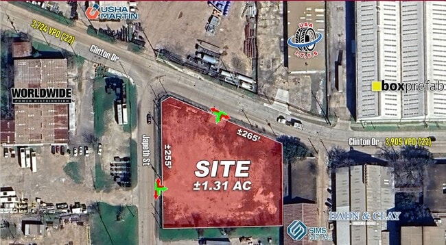
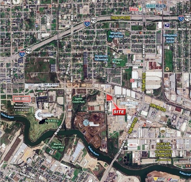
4818 Clinton Dr
Houston-The Woodlands-Sugar Land, TX
Japhet
0212130000013
LTS 2 3 10 & 11 & TRS 4B & 9B BLK 13 JAPHET
Commercialnec
Harris
X
Texas
48201C0690N
2
2024
0.49 AC
2025
Gulf Freeway/Pasadena
211400
Houston
5,600 SF
DEMOGRAPHICS near 4818 Clinton Dr
1 Mile
3 Mile
5 Mile
2024 Total Population
8,527
133,299
375,306
2029 Population
8,913
138,383
389,622
Pop Growth 2024-2029
+ 4.53%
+ 3.81%
+ 3.81%
Average Age
36
38
37
2024 Total Households
3,164
49,813
151,827
HH Growth 2024-2029
+ 4.65%
+ 4.30%
+ 4.14%
Median Household Inc
$38,340
$43,299
$56,533
Avg Household Size
2.60
2.40
2.30
2024 Avg HH Vehicles
1.00
1.00
2.00
Median Home Value
$150,545
$197,422
$265,116
Median Year Built
1961
1962
1974
Nearby Places
- Restaurants
- Banks
- Shops
- Fitness
- Groceries
PUBLIC TRANSPORTATION
COMMUTER RAIL
Houston (Sunset Limited - Amtrak)
DRIVE
WALK
Distance
Houston (Sunset Limited - Amtrak)
8 min
3.6 mi
AIRPORT
William P Hobby
DRIVE
WALK
Distance
William P Hobby
23 min
12.1 mi
George Bush Intcntl/Houston
DRIVE
WALK
Distance
George Bush Intcntl/Houston
26 min
18.7 mi
Freight Ports
Port of Houston
DRIVE
WALK
Distance
Port of Houston
12 min
5.3 mi
Nearby Properties
Address
Land Use
TOTAL SIZE
Lot Size
Zoning
Address
Land Use
TOTAL SIZE
Lot Size
Zoning
1,383,720 SF
1.47 AC
Address
Land Use
TOTAL SIZE
Lot Size
Zoning
1,101,686 SF
1.45 AC
Address
Land Use
TOTAL SIZE
Lot Size
Zoning
973,861 SF
1.18 AC
Address
Land Use
TOTAL SIZE
Lot Size
Zoning
899,279 SF
1.18 AC
Address
Land Use
TOTAL SIZE
Lot Size
Zoning
797,208 SF
1.46 AC
Address
Land Use
TOTAL SIZE
Lot Size
Zoning
1,916,394 SF
1.46 AC
Address
Land Use
TOTAL SIZE
Lot Size
Zoning
1,871,418 SF
1.44 AC
Address
Land Use
TOTAL SIZE
Lot Size
Zoning
12,206,592 SF
212.18 AC
Address
Land Use
TOTAL SIZE
Lot Size
Zoning
1,091,726 SF
2.60 AC
Address
Land Use
TOTAL SIZE
Lot Size
Zoning
1,436,400 SF
1.44 AC
Address
Land Use
TOTAL SIZE
Lot Size
Zoning
1,321,033 SF
1.46 AC
Address
Land Use
TOTAL SIZE
Lot Size
Zoning
1,374,271 SF
1.44 AC
Address
Land Use
TOTAL SIZE
Lot Size
Zoning
515,025 SF
1.50 AC
Address
Land Use
TOTAL SIZE
Lot Size
Zoning
1,657,484 SF
1.44 AC
Address
Land Use
TOTAL SIZE
Lot Size
Zoning
1,311,133 SF
1.44 AC
Address
Land Use
TOTAL SIZE
Lot Size
Zoning
1,181,384 SF
1.47 AC
Address
Land Use
TOTAL SIZE
Lot Size
Zoning
1,162,204 SF
1.44 AC
Address
Land Use
TOTAL SIZE
Lot Size
Zoning
934,258 SF
1.45 AC
Address
Land Use
TOTAL SIZE
Lot Size
Zoning
1,103,424 SF
1.44 AC
Address
Land Use
TOTAL SIZE
Lot Size
Zoning
1,365,801 SF
1.44 AC
Address
Land Use
TOTAL SIZE
Lot Size
Zoning
1,017,783 SF
1.44 AC
Address
Land Use
TOTAL SIZE
Lot Size
Zoning
1,182,525 SF
1.11 AC
Address
Land Use
TOTAL SIZE
Lot Size
Zoning
612,078 SF
1.44 AC
Address
Land Use
TOTAL SIZE
Lot Size
Zoning
468,513 SF
0.86 AC
Address
Land Use
TOTAL SIZE
Lot Size
Zoning
1,392,720 SF
83.75 AC
Address
Land Use
TOTAL SIZE
Lot Size
Zoning
1,102,279 SF
1.44 AC
Address
Land Use
TOTAL SIZE
Lot Size
Zoning
396,910 SF
0.44 AC
Address
Land Use
TOTAL SIZE
Lot Size
Zoning
1,008,419 SF
1.44 AC
Address
Land Use
TOTAL SIZE
Lot Size
Zoning
871,650 SF
0.62 AC
Address
Land Use
TOTAL SIZE
Lot Size
Zoning
656,994 SF
4.01 AC
The World's #1 Commercial Real Estate Marketplace
Connect with us
© 2025 CoStar Group
The information above has been obtained from sources believed reliable. While we do not doubt its accuracy we have not verified it and make no guarantee, warranty or representation about it. It is your responsibility to independently confirm its accuracy and completeness. Any projections, opinions, assumptions, or estimates used are for example only and do not represent the current or future performance of the property. The value of this transaction to you depends on tax and other factors which should be evaluated by your tax, financial, and legal advisors. You and your advisors should conduct a careful, independent investigation of the property to determine to your satisfaction the suitability of the property for your needs.