Property Record
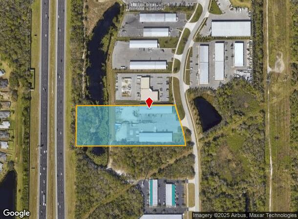
4816 Lena Rd, Bradenton, FL 34211
NEARBY LISTINGS FOR SALE OR LEASE
Property Detail
4816 Lena Rd
North Port-Bradenton-Sarasota, FL
Creekwood East Corporate Park
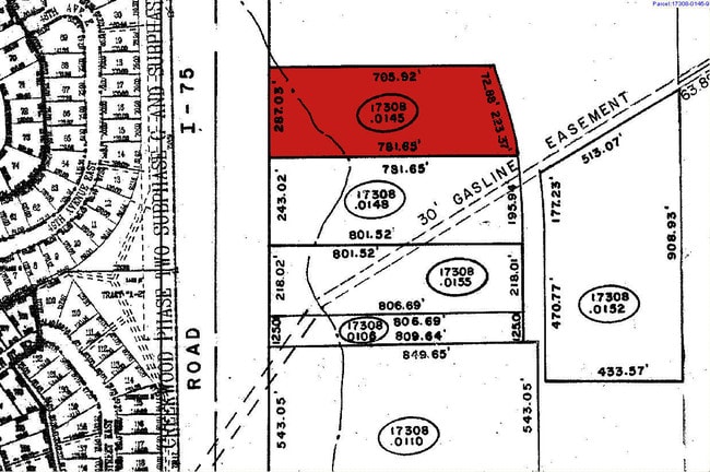
17308-5112-9
LOT 22 CREEKWOOD EAST CORPORATE PARK PI#17308.5112/9
Warehouse
Manatee
X
Florida
12115C0075F
22
2024
4.92 AC
2025
Manatee Outlying
002021
Tampa/St Petersburg
27,960 SF
DEMOGRAPHICS near 4816 Lena Rd
1 mile
3 mile
5 mile
2024 Total Population
4,263
41,542
124,331
2029 Population
4,950
49,169
145,473
Pop Growth 2024-2029
+ 16.12%
+ 18.36%
+ 17.00%
Average Age
51
47
48
2024 Total Households
1,820
17,536
52,710
HH Growth 2024-2029
+ 15.27%
+ 17.33%
+ 16.09%
Median Household Inc
$107,678
$99,671
$92,246
Avg Household Size
2.30
2.30
2.30
2024 Avg HH Vehicles
2.00
2.00
2.00
Median Home Value
$365,268
$379,813
$386,355
Median Year Built
1997
2007
2003
Nearby Places
Map Layers
Map Styles
 Street
 Aerial
Transit
 Traffic
 Biking
Places
Listings with unknown addresses are not visible on the map
- Restaurants
- Banks
- Shops
- Fitness
- Groceries
PUBLIC TRANSPORTATION
AIRPORT
Sarasota/Bradenton International
Drive
Walk
Distance
Sarasota/Bradenton International
25 min
12.6 mi
Freight Ports
Port Manatee
Drive
Walk
Distance
Port Manatee
30 min
18.5 mi
Nearby Properties
Address
Land Use
TOTAL SIZE
Lot Size
Zoning
Address
Land Use
TOTAL SIZE
Lot Size
Zoning
602,710 SF
36.57 AC
PD-MU
Address
Land Use
TOTAL SIZE
Lot Size
Zoning
451,049 SF
55.56 AC
PDMU
Address
Land Use
TOTAL SIZE
Lot Size
Zoning
349,074 SF
15.03 AC
PD-MU
Address
Land Use
TOTAL SIZE
Lot Size
Zoning
512,380 SF
11.24 AC
PD-MU
Address
Land Use
TOTAL SIZE
Lot Size
Zoning
483,594 SF
23.32 AC
PD-MU
Address
Land Use
TOTAL SIZE
Lot Size
Zoning
282,022 SF
21.30 AC
GC GENERA
Address
Land Use
TOTAL SIZE
Lot Size
Zoning
335,712 SF
27.91 AC
PD-MU
Address
Land Use
TOTAL SIZE
Lot Size
Zoning
349,151 SF
16.70 AC
PD-MU
Address
Land Use
TOTAL SIZE
Lot Size
Zoning
384,346 SF
56.41 AC
PD-PI
Address
Land Use
TOTAL SIZE
Lot Size
Zoning
405,307 SF
23.79 AC
PD-MU
Address
Land Use
TOTAL SIZE
Lot Size
Zoning
201,213 SF
27.17 AC
PD-MU
Address
Land Use
TOTAL SIZE
Lot Size
Zoning
211,519 SF
82.32 AC
PD-MU
Address
Land Use
TOTAL SIZE
Lot Size
Zoning
303,515 SF
36.98 AC
PD-MU
Address
Land Use
TOTAL SIZE
Lot Size
Zoning
241,504 SF
27.72 AC
A GENERAL
Address
Land Use
TOTAL SIZE
Lot Size
Zoning
293,332 SF
50.52 AC
A-1 SUBURB
Address
Land Use
TOTAL SIZE
Lot Size
Zoning
125,972 SF
24.18 AC
PD-PI
Address
Land Use
TOTAL SIZE
Lot Size
Zoning
175,410 SF
39.05 AC
PD-MU
Address
Land Use
TOTAL SIZE
Lot Size
Zoning
343,415 SF
31.02 AC
PD-C
Address
Land Use
TOTAL SIZE
Lot Size
Zoning
112,961 SF
19.44 AC
Address
Land Use
TOTAL SIZE
Lot Size
Zoning
345,812 SF
37 AC
PD-R
Address
Land Use
TOTAL SIZE
Lot Size
Zoning
89,137 SF
11.61 AC
Address
Land Use
TOTAL SIZE
Lot Size
Zoning
227,842 SF
12.97 AC
PD-C
Address
Land Use
TOTAL SIZE
Lot Size
Zoning
29,566 SF
1.17 AC
PD-PI
Address
Land Use
TOTAL SIZE
Lot Size
Zoning
160,163 SF
16.35 AC
PD-MU
Address
Land Use
TOTAL SIZE
Lot Size
Zoning
109,010 SF
7 AC
PD-MU
Address
Land Use
TOTAL SIZE
Lot Size
Zoning
125,678 SF
48.86 AC
Address
Land Use
TOTAL SIZE
Lot Size
Zoning
10,389 SF
57.58 AC
PD-RV
Address
Land Use
TOTAL SIZE
Lot Size
Zoning
94,206 SF
10.62 AC
PD-C
Address
Land Use
TOTAL SIZE
Lot Size
Zoning
5,926 SF
48.76 AC
RSMH-6
Address
Land Use
TOTAL SIZE
Lot Size
Zoning
121,771 SF
28.17 AC
A-1 SUBURB
The World's #1 Commercial Real Estate Marketplace
Connect with us
© 2026 CoStar Group
The information above has been obtained from sources believed reliable. While we do not doubt its accuracy we have not verified it and make no guarantee, warranty or representation about it. It is your responsibility to independently confirm its accuracy and completeness. Any projections, opinions, assumptions, or estimates used are for example only and do not represent the current or future performance of the property. The value of this transaction to you depends on tax and other factors which should be evaluated by your tax, financial, and legal advisors. You and your advisors should conduct a careful, independent investigation of the property to determine to your satisfaction the suitability of the property for your needs.