Property Record
4817 Se Dixie Hwy, Stuart, FL 34997
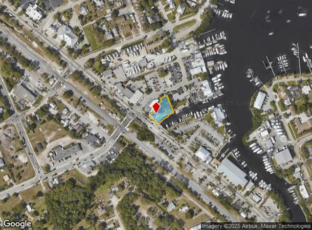
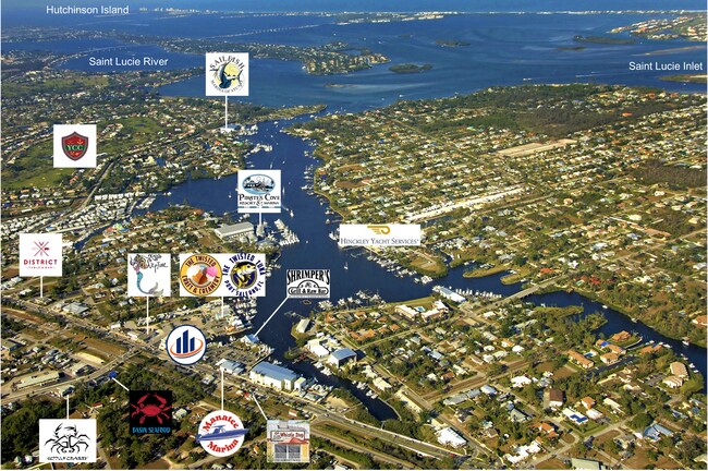
NEARBY LISTINGS FOR SALE OR LEASE
Property Detail
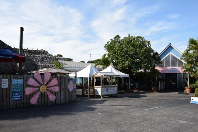
4817 Se Dixie Hwy
Port St. Lucie, FL
Port Salerno
51-38-41-002-069-00030-4
PORT SALERNO REVISED PLAT LOTS 3 & 4 & ALL LOTS 5 & 6 BLK 69 BARE BONES BREWERY & GRILLE
Restaurantbuilding
Martin
AE
Florida
12085C0164H
3 & 4
2024
0.35 AC
2025
Martin
001301
Port St Lucie/Fort Pierce
5,409 SF
DEMOGRAPHICS near 4817 Se Dixie Hwy
1 Mile
3 Mile
5 Mile
2024 Total Population
7,140
41,871
79,497
2029 Population
7,571
44,100
84,083
Pop Growth 2024-2029
+ 6.04%
+ 5.32%
+ 5.77%
Average Age
46
49
50
2024 Total Households
3,013
18,340
36,108
HH Growth 2024-2029
+ 5.87%
+ 5.46%
+ 5.95%
Median Household Inc
$59,446
$61,780
$61,433
Avg Household Size
2.30
2.20
2.10
2024 Avg HH Vehicles
2.00
2.00
2.00
Median Home Value
$292,074
$303,471
$306,558
Median Year Built
1983
1985
1984
Nearby Places
Map Layers
Map Styles
 Street
 Aerial
- Restaurants
- Banks
- Shops
- Fitness
- Groceries
SALE & LEASE HISTORY
LISTING DATE
SALE/LEASE

Oct 26, 2021
For Sale
Nearby Properties
Address
Land Use
TOTAL SIZE
Lot Size
Zoning
Address
Land Use
TOTAL SIZE
Lot Size
Zoning
436,532 SF
636.83 AC
PAF
Address
Land Use
TOTAL SIZE
Lot Size
Zoning
309,276 SF
13.73 AC
CPUD
Address
Land Use
TOTAL SIZE
Lot Size
Zoning
232,042 SF
30.99 AC
PUDR
Address
Land Use
TOTAL SIZE
Lot Size
Zoning
13.62 AC
R2
Address
Land Use
TOTAL SIZE
Lot Size
Zoning
118,989 SF
12.43 AC
PUDC
Address
Land Use
TOTAL SIZE
Lot Size
Zoning
200,686 SF
9.98 AC
RPUD
Address
Land Use
TOTAL SIZE
Lot Size
Zoning
284,610 SF
33.04 AC
R3
Address
Land Use
TOTAL SIZE
Lot Size
Zoning
545,151 SF
62.49 AC
PAF
Address
Land Use
TOTAL SIZE
Lot Size
Zoning
126,304 SF
36 AC
R2
Address
Land Use
TOTAL SIZE
Lot Size
Zoning
307,010 SF
33.70 AC
CPUD
Address
Land Use
TOTAL SIZE
Lot Size
Zoning
45,029 SF
11.80 AC
PUDC
Address
Land Use
TOTAL SIZE
Lot Size
Zoning
136,749 SF
14.90 AC
GC
Address
Land Use
TOTAL SIZE
Lot Size
Zoning
212,454 SF
33.77 AC
CPUD
Address
Land Use
TOTAL SIZE
Lot Size
Zoning
171,655 SF
15.17 AC
B2
Address
Land Use
TOTAL SIZE
Lot Size
Zoning
136,615 SF
21.72 AC
Address
Land Use
TOTAL SIZE
Lot Size
Zoning
48,450 SF
7.94 AC
Address
Land Use
TOTAL SIZE
Lot Size
Zoning
30,423 SF
13.74 AC
WGC
Address
Land Use
TOTAL SIZE
Lot Size
Zoning
59,023 SF
12.31 AC
Address
Land Use
TOTAL SIZE
Lot Size
Zoning
106,719 SF
4.94 AC
Address
Land Use
TOTAL SIZE
Lot Size
Zoning
106,105 SF
7.41 AC
PUDR
Address
Land Use
TOTAL SIZE
Lot Size
Zoning
102,843 SF
9.03 AC
Address
Land Use
TOTAL SIZE
Lot Size
Zoning
153,260 SF
13.50 AC
PS
Address
Land Use
TOTAL SIZE
Lot Size
Zoning
105,716 SF
10.13 AC
R5
Address
Land Use
TOTAL SIZE
Lot Size
Zoning
192,772 SF
18.80 AC
M1
Address
Land Use
TOTAL SIZE
Lot Size
Zoning
50,773 SF
9.40 AC
COR2
Address
Land Use
TOTAL SIZE
Lot Size
Zoning
100,318 SF
14.98 AC
CPUD
Address
Land Use
TOTAL SIZE
Lot Size
Zoning
131,383 SF
8.80 AC
R3A
Address
Land Use
TOTAL SIZE
Lot Size
Zoning
63,133 SF
19.65 AC
A1
Address
Land Use
TOTAL SIZE
Lot Size
Zoning
135,537 SF
15.28 AC
CPUD
Address
Land Use
TOTAL SIZE
Lot Size
Zoning
83,348 SF
8.12 AC
PUDR
The World's #1 Commercial Real Estate Marketplace
Connect with us
© 2026 CoStar Group
The information above has been obtained from sources believed reliable. While we do not doubt its accuracy we have not verified it and make no guarantee, warranty or representation about it. It is your responsibility to independently confirm its accuracy and completeness. Any projections, opinions, assumptions, or estimates used are for example only and do not represent the current or future performance of the property. The value of this transaction to you depends on tax and other factors which should be evaluated by your tax, financial, and legal advisors. You and your advisors should conduct a careful, independent investigation of the property to determine to your satisfaction the suitability of the property for your needs.