Property Record
482 Mcbride Rd, Mount Airy, NC 27030
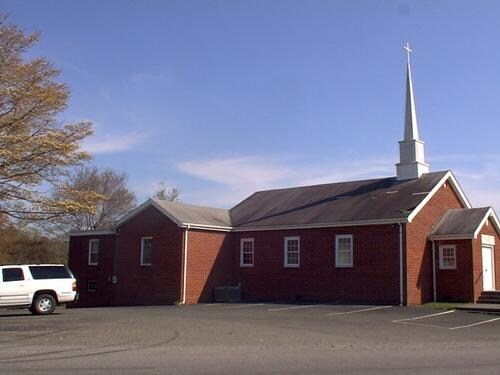

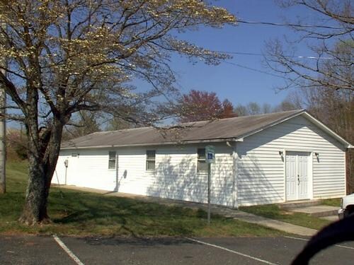
Property Detail
482 Mcbride Rd
5031-00-72-5583
SR 1742
Religious
Surry
RA
North Carolina
B and X Area of moderate flood hazard, usually the area between the limits of the 100-year and 500-year floods.
0.86 AC
0
Hickory/Morganton
2025
Other Market Areas
930201
Mount Airy, NC
6,048 SF
NEARBY LISTINGS FOR SALE OR LEASE
-
-
View all Mount Airy listings for sale on LoopNet.com
DEMOGRAPHICS near 482 Mcbride Rd
1 mile
3 mile
5 mile
2025 Total Population
1,629
14,206
24,829
2030 Population
1,669
14,424
25,050
Pop Growth 2025-2030
+ 2.46%
+ 1.53%
+ 0.89%
Average Age
43
43
44
2025 Total Households
687
6,231
10,807
HH Growth 2025-2030
+ 2.62%
+ 1.56%
+ 0.93%
Median Household Inc
$39,695
$43,709
$44,182
Avg Household Size
2.30
2.20
2.20
2025 Avg HH Vehicles
2.00
2.00
2.00
Median Home Value
$133,799
$167,533
$170,309
Median Year Built
1977
1973
1975
Nearby Places
Map Layers
Map Styles
 Street
 Aerial
Layers
 Traffic
 Biking
Places
Listings with unknown addresses are not visible on the map
- Restaurants
- Banks
- Shops
- Fitness
- Groceries
Nearby Properties
Address
Land Use
TOTAL SIZE
Lot Size
Zoning
Address
Land Use
TOTAL SIZE
Lot Size
Zoning
200,663 SF
10.49 AC
R8
Address
Land Use
TOTAL SIZE
Lot Size
Zoning
86,738 SF
29.44 AC
R6
Address
Land Use
TOTAL SIZE
Lot Size
Zoning
93,565 SF
23.80 AC
R8
Address
Land Use
TOTAL SIZE
Lot Size
Zoning
112,521 SF
10.33 AC
B4
Address
Land Use
TOTAL SIZE
Lot Size
Zoning
10,592 SF
18.17 AC
CU-B5
Address
Land Use
TOTAL SIZE
Lot Size
Zoning
79,958 SF
20.05 AC
R8
Address
Land Use
TOTAL SIZE
Lot Size
Zoning
9,180 SF
214 AC
MI
Address
Land Use
TOTAL SIZE
Lot Size
Zoning
60,016 SF
10.16 AC
R8
Address
Land Use
TOTAL SIZE
Lot Size
Zoning
39,656 SF
11.65 AC
B2
Address
Land Use
TOTAL SIZE
Lot Size
Zoning
51,045 SF
2.60 AC
R6
Address
Land Use
TOTAL SIZE
Lot Size
Zoning
171,232 SF
22.65 AC
M1
Address
Land Use
TOTAL SIZE
Lot Size
Zoning
21,316 SF
19 AC
RG
Address
Land Use
TOTAL SIZE
Lot Size
Zoning
54,310 SF
B4
Address
Land Use
TOTAL SIZE
Lot Size
Zoning
57,205 SF
6.03 AC
B2
Address
Land Use
TOTAL SIZE
Lot Size
Zoning
18,666 SF
2 AC
B4
Address
Land Use
TOTAL SIZE
Lot Size
Zoning
21,994 SF
2.50 AC
B2
Address
Land Use
TOTAL SIZE
Lot Size
Zoning
29,785 SF
4.90 AC
R8
Address
Land Use
TOTAL SIZE
Lot Size
Zoning
79,794 SF
16.50 AC
B4
Address
Land Use
TOTAL SIZE
Lot Size
Zoning
19,282 SF
4.33 AC
R6
Address
Land Use
TOTAL SIZE
Lot Size
Zoning
205,777 SF
11.35 AC
M1
Address
Land Use
TOTAL SIZE
Lot Size
Zoning
49,982 SF
2 AC
B2
Address
Land Use
TOTAL SIZE
Lot Size
Zoning
87,332 SF
13.47 AC
M1
Address
Land Use
TOTAL SIZE
Lot Size
Zoning
49,715 SF
5.18 AC
B4
Address
Land Use
TOTAL SIZE
Lot Size
Zoning
196,944 SF
32.74 AC
M1
Address
Land Use
TOTAL SIZE
Lot Size
Zoning
19,502 SF
153.88 AC
RA
Address
Land Use
TOTAL SIZE
Lot Size
Zoning
4,000 SF
14.34 AC
M1
Address
Land Use
TOTAL SIZE
Lot Size
Zoning
20,728 SF
3.01 AC
R6
Address
Land Use
TOTAL SIZE
Lot Size
Zoning
30,250 SF
3.44 AC
M1
Address
Land Use
TOTAL SIZE
Lot Size
Zoning
65,852 SF
5.46 AC
M1
Address
Land Use
TOTAL SIZE
Lot Size
Zoning
13,680 SF
1.31 AC
R4
The World's #1 Commercial Real Estate Marketplace
Connect with us
© 2026 CoStar Group
The information above has been obtained from sources believed reliable. While we do not doubt its accuracy we have not verified it and make no guarantee, warranty or representation about it. It is your responsibility to independently confirm its accuracy and completeness. Any projections, opinions, assumptions, or estimates used are for example only and do not represent the current or future performance of the property. The value of this transaction to you depends on tax and other factors which should be evaluated by your tax, financial, and legal advisors. You and your advisors should conduct a careful, independent investigation of the property to determine to your satisfaction the suitability of the property for your needs.