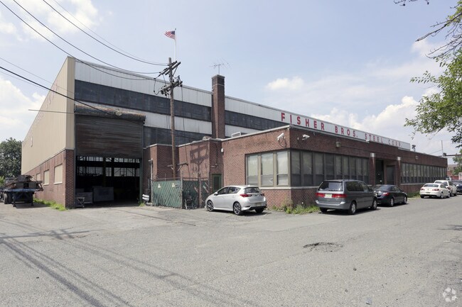
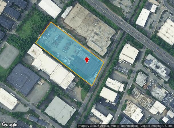
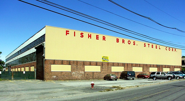
Property Record
482 Nordhoff Pl, Englewood, NJ 07631

NEARBY LISTINGS FOR SALE OR LEASE
Property Detail
482 Nordhoff Pl
15-02602-0000-00006
4.51 AC
Industrialgeneral
Bergen
AE
New Jersey
34003C0213H
6
2024
4.51 AC
2025
Englewood/Edgewater
015402
Northern New Jersey
44,928 SF
New York-Jersey City-White Plains, NY-NJ
DEMOGRAPHICS near 482 Nordhoff Pl
1 Mile
3 Mile
5 Mile
2024 Total Population
18,204
189,621
1,145,334
2029 Population
18,083
188,553
1,094,716
Pop Growth 2024-2029
(0.66%)
(0.56%)
(4.42%)
Average Age
41
42
40
2024 Total Households
6,944
71,091
427,058
HH Growth 2024-2029
(0.79%)
(0.48%)
(4.67%)
Median Household Inc
$100,774
$100,066
$60,772
Avg Household Size
2.50
2.60
2.50
2024 Avg HH Vehicles
2.00
2.00
1.00
Median Home Value
$460,844
$478,406
$479,134
Median Year Built
1968
1960
1951
Nearby Places
Map Layers
Map Styles
 Street
 Aerial
- Restaurants
- Banks
- Shops
- Fitness
- Groceries
PUBLIC TRANSPORTATION
COMMUTER RAIL
Anderson Street (Pascack Valley Line - NJ Transit Commuter Rail (NJ Transit))
DRIVE
WALK
Distance
Anderson Street (Pascack Valley Line - NJ Transit Commuter Rail (NJ Transit))
8 min
4.2 mi
Spuyten Duyvil Station (Hudson Line - Metro-North Commuter Railroad Company (Metro-North))
DRIVE
WALK
Distance
Spuyten Duyvil Station (Hudson Line - Metro-North Commuter Railroad Company (Metro-North))
16 min
8.2 mi
AIRPORT
LaGuardia
DRIVE
WALK
Distance
LaGuardia
26 min
14.1 mi
Newark Liberty International
DRIVE
WALK
Distance
Newark Liberty International
22 min
17.9 mi
Westchester County
DRIVE
WALK
Distance
Westchester County
46 min
29.9 mi
Freight Ports
NY - Red Hook Container Terminal
DRIVE
WALK
Distance
NY - Red Hook Container Terminal
36 min
20.2 mi
Nearby Properties
Address
Land Use
TOTAL SIZE
Lot Size
Zoning
Address
Land Use
TOTAL SIZE
Lot Size
Zoning
26.93 AC
R8
Address
Land Use
TOTAL SIZE
Lot Size
Zoning
111.37 AC
P1
Address
Land Use
TOTAL SIZE
Lot Size
Zoning
24.08 AC
B2-A
Address
Land Use
TOTAL SIZE
Lot Size
Zoning
4.87 AC
R11
Address
Land Use
TOTAL SIZE
Lot Size
Zoning
512,862 SF
14.16 AC
Address
Land Use
TOTAL SIZE
Lot Size
Zoning
Address
Land Use
TOTAL SIZE
Lot Size
Zoning
72 AC
P1
Address
Land Use
TOTAL SIZE
Lot Size
Zoning
2.61 AC
D5
Address
Land Use
TOTAL SIZE
Lot Size
Zoning
572,137 SF
14.11 AC
R-D
Address
Land Use
TOTAL SIZE
Lot Size
Zoning
20.07 AC
H
Address
Land Use
TOTAL SIZE
Lot Size
Zoning
74,550 SF
11.28 AC
OI
Address
Land Use
TOTAL SIZE
Lot Size
Zoning
42.68 AC
P1
Address
Land Use
TOTAL SIZE
Lot Size
Zoning
13.09 AC
C3
Address
Land Use
TOTAL SIZE
Lot Size
Zoning
2 AC
R11
Address
Land Use
TOTAL SIZE
Lot Size
Zoning
100,151 SF
22.13 AC
B2
Address
Land Use
TOTAL SIZE
Lot Size
Zoning
2.55 AC
D5
Address
Land Use
TOTAL SIZE
Lot Size
Zoning
39 AC
P1
Address
Land Use
TOTAL SIZE
Lot Size
Zoning
5.87 AC
R10
Address
Land Use
TOTAL SIZE
Lot Size
Zoning
5.22 AC
APT
Address
Land Use
TOTAL SIZE
Lot Size
Zoning
4.89 AC
R10
Address
Land Use
TOTAL SIZE
Lot Size
Zoning
43.65 AC
PARK
Address
Land Use
TOTAL SIZE
Lot Size
Zoning
4.54 AC
R-M3
Address
Land Use
TOTAL SIZE
Lot Size
Zoning
26.11 AC
R1
Address
Land Use
TOTAL SIZE
Lot Size
Zoning
1.68 AC
R11
Address
Land Use
TOTAL SIZE
Lot Size
Zoning
2.55 AC
RC-1
Address
Land Use
TOTAL SIZE
Lot Size
Zoning
261,303 SF
5.60 AC
O
Address
Land Use
TOTAL SIZE
Lot Size
Zoning
32 AC
P1
Address
Land Use
TOTAL SIZE
Lot Size
Zoning
4.75 AC
R9
Address
Land Use
TOTAL SIZE
Lot Size
Zoning
15.76 AC
B2
Address
Land Use
TOTAL SIZE
Lot Size
Zoning
2,191 SF
1.34 AC
B2
The World's #1 Commercial Real Estate Marketplace
Connect with us
© 2025 CoStar Group
The information above has been obtained from sources believed reliable. While we do not doubt its accuracy we have not verified it and make no guarantee, warranty or representation about it. It is your responsibility to independently confirm its accuracy and completeness. Any projections, opinions, assumptions, or estimates used are for example only and do not represent the current or future performance of the property. The value of this transaction to you depends on tax and other factors which should be evaluated by your tax, financial, and legal advisors. You and your advisors should conduct a careful, independent investigation of the property to determine to your satisfaction the suitability of the property for your needs.