Property Record
482 W Apache Trl, Apache Junction, AZ 85120
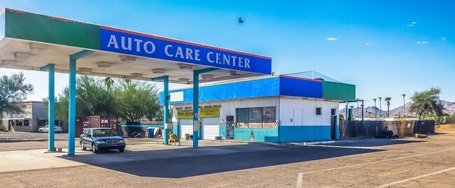


Property Detail
482 W Apache Trl
101-11-010E
COMMENCING AT SOUTHWEST CORNER OF THE NORTHEAST QUARTER OF SECTIO N 20, TOWNSHIP 01 NORTH, RANGE 08 EAST, THENCE N-136.75 FT TO THE NORTH R/W LINE OF U.S. HIGHWAY 60-70-80-89, THENCE S89D E-808.13 FT, THENCE CONTINUING S89D E-201.96 FT, TO THE POINT
Autorepair
Pinal
AH Areas with a 1% annual chance of shallow flooding, usually in the form of a pond, withan average depth ranging from 1 to 3 feet. These areas have a 26% chance of flooding over the life of a 30-year mortgage.
Arizona
2024
0.46 AC
2025
Apache Junction
000309
Phoenix
1,296 SF
Phoenix-Mesa-Chandler, AZ
NEARBY LISTINGS FOR SALE OR LEASE
DEMOGRAPHICS near 482 W Apache Trl
1 mile
3 mile
5 mile
2024 Total Population
8,995
61,814
123,965
2029 Population
10,361
70,376
136,819
Pop Growth 2024-2029
+ 15.19%
+ 13.85%
+ 10.37%
Average Age
47
46
46
2024 Total Households
4,197
26,537
51,165
HH Growth 2024-2029
+ 14.77%
+ 14.07%
+ 11.02%
Median Household Inc
$48,235
$63,303
$70,034
Avg Household Size
2.10
2.30
2.40
2024 Avg HH Vehicles
2.00
2.00
2.00
Median Home Value
$289,673
$310,653
$354,652
Median Year Built
1991
1993
1996
Nearby Places
Map Layers
Map Styles
 Street
 Aerial
Transit
 Traffic
 Biking
Places
Listings with unknown addresses are not visible on the map
- Restaurants
- Banks
- Shops
- Fitness
- Groceries
PUBLIC TRANSPORTATION
AIRPORT
Phoenix-Mesa Gateway
Drive
Walk
Distance
Phoenix-Mesa Gateway
26 min
16.4 mi
Phoenix Sky Harbor International
Drive
Walk
Distance
Phoenix Sky Harbor International
42 min
30.4 mi
SALE & LEASE HISTORY
LISTING DATE
SALE/LEASE

Sep 30, 2020
For Sale
Mar 02, 2023
For Sale
Nearby Properties
Address
Land Use
TOTAL SIZE
Lot Size
Zoning
Address
Land Use
TOTAL SIZE
Lot Size
Zoning
117,169 SF
13.27 AC
Address
Land Use
TOTAL SIZE
Lot Size
Zoning
Address
Land Use
TOTAL SIZE
Lot Size
Zoning
Address
Land Use
TOTAL SIZE
Lot Size
Zoning
128,905 SF
7.14 AC
UNDESIGNAT
Address
Land Use
TOTAL SIZE
Lot Size
Zoning
Address
Land Use
TOTAL SIZE
Lot Size
Zoning
209,737 SF
21.98 AC
UNDESIGNAT
Address
Land Use
TOTAL SIZE
Lot Size
Zoning
126,549 SF
9.75 AC
Address
Land Use
TOTAL SIZE
Lot Size
Zoning
52,961 SF
7.94 AC
Address
Land Use
TOTAL SIZE
Lot Size
Zoning
108,644 SF
10.12 AC
UNDESIGNAT
Address
Land Use
TOTAL SIZE
Lot Size
Zoning
62,290 SF
7.53 AC
UNDESIGNAT
Address
Land Use
TOTAL SIZE
Lot Size
Zoning
54,706 SF
16.20 AC
UNDESIGNAT
Address
Land Use
TOTAL SIZE
Lot Size
Zoning
173,840 SF
6 AC
UNDESIGNAT
Address
Land Use
TOTAL SIZE
Lot Size
Zoning
69,692 SF
7.26 AC
Address
Land Use
TOTAL SIZE
Lot Size
Zoning
6,335 SF
8.30 AC
Address
Land Use
TOTAL SIZE
Lot Size
Zoning
11,686 SF
40 AC
Address
Land Use
TOTAL SIZE
Lot Size
Zoning
38,353 SF
5 AC
Address
Land Use
TOTAL SIZE
Lot Size
Zoning
23,180 SF
3.90 AC
UNDESIGNAT
Address
Land Use
TOTAL SIZE
Lot Size
Zoning
30,775 SF
7.60 AC
UNDESIGNAT
Address
Land Use
TOTAL SIZE
Lot Size
Zoning
102,430 SF
5 AC
UNDESIGNAT
Address
Land Use
TOTAL SIZE
Lot Size
Zoning
26,022 SF
11.03 AC
UNDESIGNAT
Address
Land Use
TOTAL SIZE
Lot Size
Zoning
162,184 SF
4.60 AC
UNDESIGNAT
Address
Land Use
TOTAL SIZE
Lot Size
Zoning
27,121 SF
4.05 AC
Address
Land Use
TOTAL SIZE
Lot Size
Zoning
43,958 SF
4.54 AC
UNDESIGNAT
Address
Land Use
TOTAL SIZE
Lot Size
Zoning
196,400 SF
15.67 AC
Address
Land Use
TOTAL SIZE
Lot Size
Zoning
54,300 SF
4.57 AC
UNDESIGNAT
Address
Land Use
TOTAL SIZE
Lot Size
Zoning
683 SF
36.74 AC
UNDESIGNAT
Address
Land Use
TOTAL SIZE
Lot Size
Zoning
24,158 SF
5.19 AC
Address
Land Use
TOTAL SIZE
Lot Size
Zoning
62,758 SF
5 AC
UNDESIGNAT
The World's #1 Commercial Real Estate Marketplace
Connect with us
© 2026 CoStar Group
The information above has been obtained from sources believed reliable. While we do not doubt its accuracy we have not verified it and make no guarantee, warranty or representation about it. It is your responsibility to independently confirm its accuracy and completeness. Any projections, opinions, assumptions, or estimates used are for example only and do not represent the current or future performance of the property. The value of this transaction to you depends on tax and other factors which should be evaluated by your tax, financial, and legal advisors. You and your advisors should conduct a careful, independent investigation of the property to determine to your satisfaction the suitability of the property for your needs.