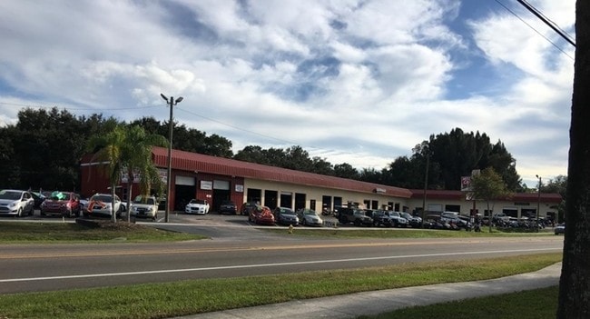
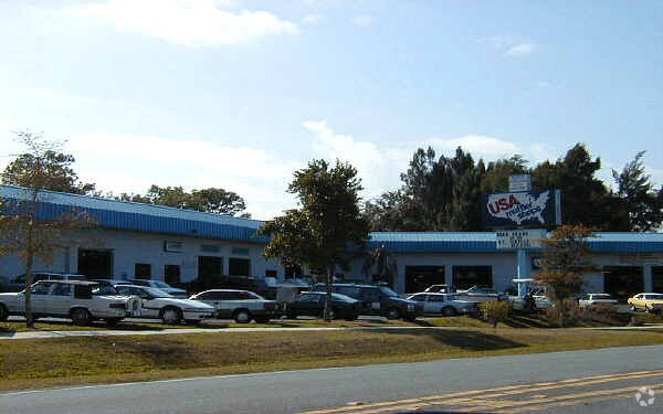
Property Record
4820 Alt 19, Palm Harbor, FL 34683

Current Lease Availabilities
NEARBY LISTINGS FOR SALE OR LEASE
Property Detail
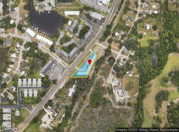
4820 Alt 19
Tampa-St. Petersburg-Clearwater, FL
Tampa & Tarpon
24-27-15-89280-000-5601
TAMPA & TARPON SPRINGS LAND CO THAT PT OF LOTS 56, 53 & 54 LYING ELY OF SR 595 & WLY OF PINELLAS TRAIL & SLY OF VALLEY RD TOGETHER WITH 30FT X 286.52FT OF PINELLAS TRAIL ADJ AS DESC IN O.R. 12780 PG 1107
Autorepair
Pinellas
AE
Florida
12103C0057H
56
2024
0.97 AC
2025
North Pinellas
027211
Tampa/St Petersburg
10,348 SF
DEMOGRAPHICS near 4820 Alt 19
1 Mile
3 Mile
5 Mile
2024 Total Population
5,180
47,883
123,217
2029 Population
5,191
47,723
126,761
Pop Growth 2024-2029
+ 0.21%
(0.33%)
+ 2.88%
Average Age
46
48
47
2024 Total Households
2,225
21,298
54,440
HH Growth 2024-2029
0.00%
(0.47%)
+ 2.82%
Median Household Inc
$68,885
$67,296
$61,530
Avg Household Size
2.20
2.20
2.20
2024 Avg HH Vehicles
2.00
2.00
2.00
Median Home Value
$349,551
$330,724
$315,374
Median Year Built
1986
1983
1984
Nearby Places
Map Layers
Map Styles
 Street
 Aerial
- Restaurants
- Banks
- Shops
- Fitness
- Groceries
PUBLIC TRANSPORTATION
AIRPORT
Tampa International
DRIVE
WALK
Distance
Tampa International
38 min
22.3 mi
St Pete-Clearwater International
DRIVE
WALK
Distance
St Pete-Clearwater International
38 min
22.5 mi
Freight Ports
Port of Tampa Bay
DRIVE
WALK
Distance
Port of Tampa Bay
52 min
30.8 mi
Nearby Properties
Address
Land Use
TOTAL SIZE
Lot Size
Zoning
Address
Land Use
TOTAL SIZE
Lot Size
Zoning
535,063 SF
34.58 AC
RPD5
Address
Land Use
TOTAL SIZE
Lot Size
Zoning
341,775 SF
43.99 AC
Address
Land Use
TOTAL SIZE
Lot Size
Zoning
214,040 SF
8.47 AC
Address
Land Use
TOTAL SIZE
Lot Size
Zoning
270,606 SF
53.27 AC
AE
Address
Land Use
TOTAL SIZE
Lot Size
Zoning
286,598 SF
6.56 AC
Address
Land Use
TOTAL SIZE
Lot Size
Zoning
171,009 SF
49.16 AC
RPD10
Address
Land Use
TOTAL SIZE
Lot Size
Zoning
208,427 SF
12.11 AC
Address
Land Use
TOTAL SIZE
Lot Size
Zoning
144,838 SF
15.52 AC
CP1
Address
Land Use
TOTAL SIZE
Lot Size
Zoning
154,033 SF
15.86 AC
Address
Land Use
TOTAL SIZE
Lot Size
Zoning
116,975 SF
9 AC
AE
Address
Land Use
TOTAL SIZE
Lot Size
Zoning
137,649 SF
8.08 AC
Address
Land Use
TOTAL SIZE
Lot Size
Zoning
273,134 SF
1.44 AC
RPD5
Address
Land Use
TOTAL SIZE
Lot Size
Zoning
151,825 SF
18.01 AC
Address
Land Use
TOTAL SIZE
Lot Size
Zoning
4,955 SF
135.03 AC
Address
Land Use
TOTAL SIZE
Lot Size
Zoning
112,719 SF
9.36 AC
CP1
Address
Land Use
TOTAL SIZE
Lot Size
Zoning
36,668 SF
65.18 AC
AE
Address
Land Use
TOTAL SIZE
Lot Size
Zoning
93,413 SF
12.35 AC
RPD10
Address
Land Use
TOTAL SIZE
Lot Size
Zoning
131,819 SF
11.24 AC
Address
Land Use
TOTAL SIZE
Lot Size
Zoning
81,053 SF
9.52 AC
Address
Land Use
TOTAL SIZE
Lot Size
Zoning
117,262 SF
15.32 AC
CP1
Address
Land Use
TOTAL SIZE
Lot Size
Zoning
141,763 SF
12.96 AC
Address
Land Use
TOTAL SIZE
Lot Size
Zoning
65,929 SF
5.96 AC
C2
Address
Land Use
TOTAL SIZE
Lot Size
Zoning
67,179 SF
9.52 AC
Address
Land Use
TOTAL SIZE
Lot Size
Zoning
63,088 SF
7.50 AC
RPD10
Address
Land Use
TOTAL SIZE
Lot Size
Zoning
86,556 SF
7.44 AC
R6
Address
Land Use
TOTAL SIZE
Lot Size
Zoning
77,716 SF
2.54 AC
Address
Land Use
TOTAL SIZE
Lot Size
Zoning
79,665 SF
7.26 AC
CP1
Address
Land Use
TOTAL SIZE
Lot Size
Zoning
143,430 SF
8.68 AC
Address
Land Use
TOTAL SIZE
Lot Size
Zoning
87,794 SF
7.97 AC
Address
Land Use
TOTAL SIZE
Lot Size
Zoning
70,901 SF
5.70 AC
The World's #1 Commercial Real Estate Marketplace
Connect with us
© 2025 CoStar Group
The information above has been obtained from sources believed reliable. While we do not doubt its accuracy we have not verified it and make no guarantee, warranty or representation about it. It is your responsibility to independently confirm its accuracy and completeness. Any projections, opinions, assumptions, or estimates used are for example only and do not represent the current or future performance of the property. The value of this transaction to you depends on tax and other factors which should be evaluated by your tax, financial, and legal advisors. You and your advisors should conduct a careful, independent investigation of the property to determine to your satisfaction the suitability of the property for your needs.