Property Record
4820 Kinnamon Rd, Winston Salem, NC 27103
NEARBY LISTINGS FOR SALE OR LEASE
Property Detail
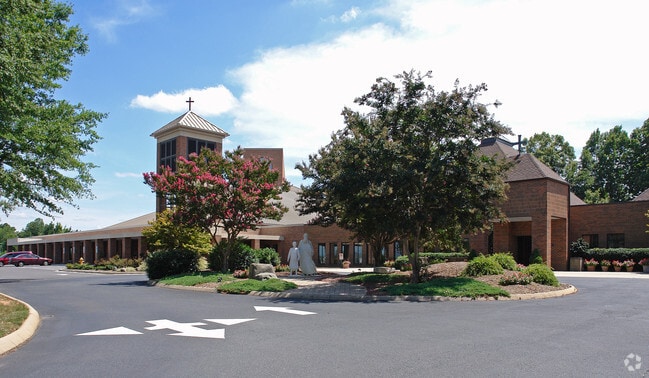
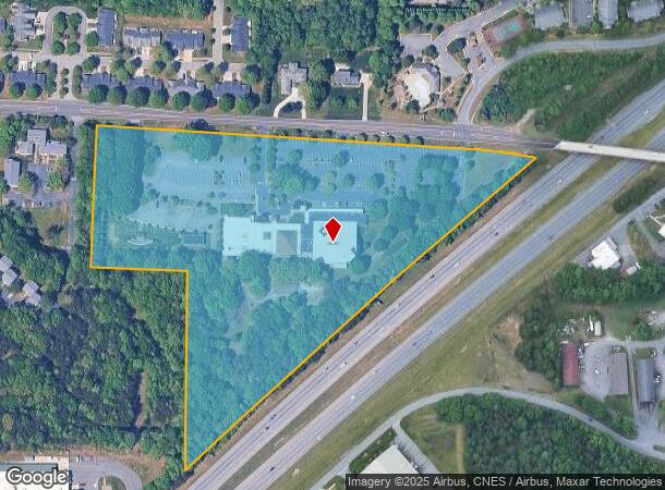
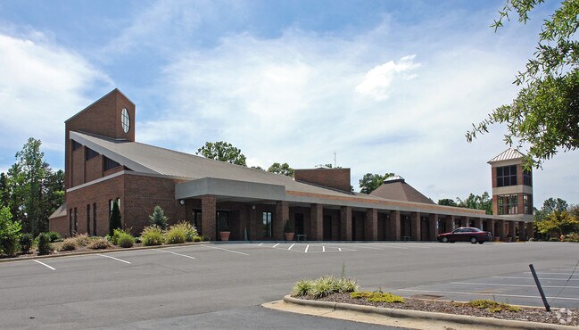
4820 Kinnamon Rd
Winston-Salem, NC
Holy Faith Catholic
5893-26-3564
HOLY FAITH CATHOLIC LO:025A BL:4233 BU:1
Religious
Forsyth
X
North Carolina
3710589300J
25a
2024
14.02 AC
2025
Clemmons
004013
Greensboro/Winston-Salem
1,071 SF
DEMOGRAPHICS near 4820 Kinnamon Rd
1 Mile
3 Mile
5 Mile
2024 Total Population
5,971
36,578
85,066
2029 Population
6,155
37,873
88,715
Pop Growth 2024-2029
+ 3.08%
+ 3.54%
+ 4.29%
Average Age
40
42
42
2024 Total Households
2,412
15,022
36,470
HH Growth 2024-2029
+ 3.07%
+ 3.57%
+ 4.27%
Median Household Inc
$69,427
$78,586
$74,384
Avg Household Size
2.40
2.40
2.30
2024 Avg HH Vehicles
2.00
2.00
2.00
Median Home Value
$256,362
$263,164
$266,260
Median Year Built
1992
1991
1988
Nearby Places
Map Layers
Map Styles
 Street
 Aerial
- Restaurants
- Banks
- Shops
- Fitness
- Groceries
PUBLIC TRANSPORTATION
AIRPORT
Piedmont Triad International
DRIVE
WALK
Distance
Piedmont Triad International
44 min
30.7 mi
Freight Ports
Port of Wilmington
DRIVE
WALK
Distance
Port of Wilmington
282 min
239.4 mi
Nearby Properties
Address
Land Use
TOTAL SIZE
Lot Size
Zoning
Address
Land Use
TOTAL SIZE
Lot Size
Zoning
130,696 SF
41.18 AC
PB-S
Address
Land Use
TOTAL SIZE
Lot Size
Zoning
100,233 SF
19.65 AC
PB-S
Address
Land Use
TOTAL SIZE
Lot Size
Zoning
121,563 SF
22.42 AC
PB-S
Address
Land Use
TOTAL SIZE
Lot Size
Zoning
68,656 SF
6.25 AC
MU-S
Address
Land Use
TOTAL SIZE
Lot Size
Zoning
257,080 SF
23.47 AC
HB-S
Address
Land Use
TOTAL SIZE
Lot Size
Zoning
60,258 SF
8.04 AC
PB-S
Address
Land Use
TOTAL SIZE
Lot Size
Zoning
183,444 SF
45.19 AC
RS9
Address
Land Use
TOTAL SIZE
Lot Size
Zoning
200,651 SF
60 AC
IP
Address
Land Use
TOTAL SIZE
Lot Size
Zoning
99,812 SF
18.33 AC
RM12
Address
Land Use
TOTAL SIZE
Lot Size
Zoning
402,885 SF
19.63 AC
HB-S
Address
Land Use
TOTAL SIZE
Lot Size
Zoning
64,236 SF
14.71 AC
RM12-S
Address
Land Use
TOTAL SIZE
Lot Size
Zoning
655,160 SF
52.15 AC
GI
Address
Land Use
TOTAL SIZE
Lot Size
Zoning
80,171 SF
4.32 AC
PB-S
Address
Land Use
TOTAL SIZE
Lot Size
Zoning
116,655 SF
10.16 AC
LI
Address
Land Use
TOTAL SIZE
Lot Size
Zoning
60,296 SF
0.66 AC
PB-S
Address
Land Use
TOTAL SIZE
Lot Size
Zoning
56,638 SF
16.54 AC
RM8-S
Address
Land Use
TOTAL SIZE
Lot Size
Zoning
68,277 SF
9.82 AC
GB-S
Address
Land Use
TOTAL SIZE
Lot Size
Zoning
75,507 SF
12.46 AC
RM18
Address
Land Use
TOTAL SIZE
Lot Size
Zoning
79,498 SF
10.64 AC
HB
Address
Land Use
TOTAL SIZE
Lot Size
Zoning
71,306 SF
10.36 AC
IP-S
Address
Land Use
TOTAL SIZE
Lot Size
Zoning
129,268 SF
9.98 AC
HB-S
Address
Land Use
TOTAL SIZE
Lot Size
Zoning
75,361 SF
15.20 AC
RM12
Address
Land Use
TOTAL SIZE
Lot Size
Zoning
45,427 SF
17.84 AC
RM8-S
Address
Land Use
TOTAL SIZE
Lot Size
Zoning
44,836 SF
14.01 AC
RM12
Address
Land Use
TOTAL SIZE
Lot Size
Zoning
100,044 SF
7.93 AC
HB,HB-S
Address
Land Use
TOTAL SIZE
Lot Size
Zoning
101,346 SF
8.25 AC
HB-S
Address
Land Use
TOTAL SIZE
Lot Size
Zoning
52,554 SF
25.46 AC
RS9
Address
Land Use
TOTAL SIZE
Lot Size
Zoning
53,969 SF
10.52 AC
RM12-S
Address
Land Use
TOTAL SIZE
Lot Size
Zoning
69,062 SF
13.44 AC
RM18
Address
Land Use
TOTAL SIZE
Lot Size
Zoning
32,696 SF
1.64 AC
PB-S
The World's #1 Commercial Real Estate Marketplace
Connect with us
© 2025 CoStar Group
The information above has been obtained from sources believed reliable. While we do not doubt its accuracy we have not verified it and make no guarantee, warranty or representation about it. It is your responsibility to independently confirm its accuracy and completeness. Any projections, opinions, assumptions, or estimates used are for example only and do not represent the current or future performance of the property. The value of this transaction to you depends on tax and other factors which should be evaluated by your tax, financial, and legal advisors. You and your advisors should conduct a careful, independent investigation of the property to determine to your satisfaction the suitability of the property for your needs.