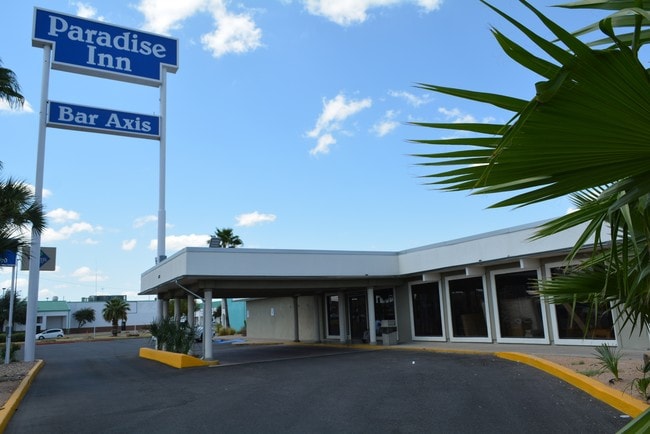
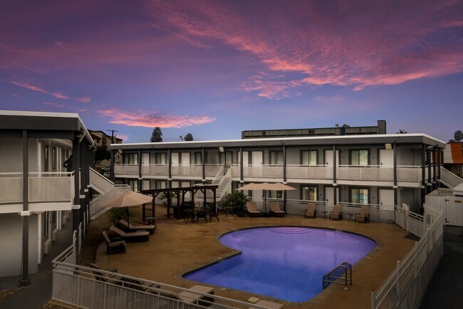
Property Record
4820 San Bernardo Ave, Laredo, TX 78041

Property Detail
4820 San Bernardo Ave
545369
AXIS HOSPITALITY PLAT, BLOCK 1, LOT 1
Commercialnec
Webb
B3
Texas
AO River or stream flood hazard areas, and areas with a 1% or greater chance of shallow flooding each year. These areas have a 26% chance of flooding over the life of a 30-year mortgage.
1
2024
1.90 AC
2025
Texas South Area
001401
Other Market Areas
24,778 SF
Laredo, TX
NEARBY LISTINGS FOR SALE OR LEASE
-
-
View all Laredo listings for sale on LoopNet.com
DEMOGRAPHICS near 4820 San Bernardo Ave
1 mile
3 mile
5 mile
2025 Total Population
14,767
92,251
180,451
2030 Population
14,979
93,947
184,168
Pop Growth 2025-2030
+ 1.44%
+ 1.84%
+ 2.06%
Average Age
37
37
36
2025 Total Households
4,874
30,156
56,494
HH Growth 2025-2030
+ 1.64%
+ 2.03%
+ 2.26%
Median Household Inc
$43,301
$48,530
$59,956
Avg Household Size
2.90
3.00
3.10
2025 Avg HH Vehicles
2.00
2.00
2.00
Median Home Value
$159,624
$187,934
$214,728
Median Year Built
1977
1981
1992
Nearby Places
Map Layers
Map Styles
 Street
 Aerial
Transit
 Traffic
 Biking
Places
Listings with unknown addresses are not visible on the map
- Restaurants
- Banks
- Shops
- Fitness
- Groceries
PUBLIC TRANSPORTATION
AIRPORT
Laredo International
Drive
Walk
Distance
Laredo International
12 min
6.1 mi
SALE & LEASE HISTORY
LISTING DATE
SALE/LEASE

Sep 21, 2017
For Sale
Sep 12, 2018
For Sale
Jan 24, 2023
For Sale
Jan 06, 2020
For Sale
Feb 28, 2022
For Sale
Nearby Properties
Address
Land Use
TOTAL SIZE
Lot Size
Zoning
Address
Land Use
TOTAL SIZE
Lot Size
Zoning
1,019,636 SF
202.89 AC
B3
Address
Land Use
TOTAL SIZE
Lot Size
Zoning
668,900 SF
38.32 AC
B4
Address
Land Use
TOTAL SIZE
Lot Size
Zoning
497,463 SF
1.77 AC
R1
Address
Land Use
TOTAL SIZE
Lot Size
Zoning
489,093 SF
32.23 AC
B4
Address
Land Use
TOTAL SIZE
Lot Size
Zoning
152.08 AC
M1
Address
Land Use
TOTAL SIZE
Lot Size
Zoning
224,926 SF
21.49 AC
R3
Address
Land Use
TOTAL SIZE
Lot Size
Zoning
689,547 SF
2.70 AC
B3
Address
Land Use
TOTAL SIZE
Lot Size
Zoning
258,114 SF
30.54 AC
B1
Address
Land Use
TOTAL SIZE
Lot Size
Zoning
144,491 SF
3.54 AC
CBD
Address
Land Use
TOTAL SIZE
Lot Size
Zoning
227,503 SF
19.84 AC
B4
Address
Land Use
TOTAL SIZE
Lot Size
Zoning
96,991 SF
1.59 AC
CBD
Address
Land Use
TOTAL SIZE
Lot Size
Zoning
164,276 SF
43.92 AC
Address
Land Use
TOTAL SIZE
Lot Size
Zoning
192,176 SF
34.94 AC
Address
Land Use
TOTAL SIZE
Lot Size
Zoning
127,364 SF
1.60 AC
CBD
Address
Land Use
TOTAL SIZE
Lot Size
Zoning
109,695 SF
3.73 AC
M1
Address
Land Use
TOTAL SIZE
Lot Size
Zoning
355,229 SF
15.41 AC
M1
Address
Land Use
TOTAL SIZE
Lot Size
Zoning
157,376 SF
25.86 AC
B3
Address
Land Use
TOTAL SIZE
Lot Size
Zoning
218,415 SF
13.41 AC
R3
Address
Land Use
TOTAL SIZE
Lot Size
Zoning
122,752 SF
17.16 AC
R2
Address
Land Use
TOTAL SIZE
Lot Size
Zoning
144,522 SF
3.86 AC
B3
Address
Land Use
TOTAL SIZE
Lot Size
Zoning
25,104 SF
1.42 AC
CBD
Address
Land Use
TOTAL SIZE
Lot Size
Zoning
139,521 SF
18.13 AC
M1
Address
Land Use
TOTAL SIZE
Lot Size
Zoning
101,734 SF
1.63 AC
B3
Address
Land Use
TOTAL SIZE
Lot Size
Zoning
100,598 SF
26.22 AC
Address
Land Use
TOTAL SIZE
Lot Size
Zoning
66,567 SF
3.81 AC
M1
Address
Land Use
TOTAL SIZE
Lot Size
Zoning
113,687 SF
5.58 AC
R3
Address
Land Use
TOTAL SIZE
Lot Size
Zoning
93,414 SF
8.57 AC
R1
Address
Land Use
TOTAL SIZE
Lot Size
Zoning
98,005 SF
0.67 AC
B3
Address
Land Use
TOTAL SIZE
Lot Size
Zoning
70,980 SF
1.44 AC
CBD
Address
Land Use
TOTAL SIZE
Lot Size
Zoning
138,920 SF
13.06 AC
The World's #1 Commercial Real Estate Marketplace
Connect with us
© 2026 CoStar Group
The information above has been obtained from sources believed reliable. While we do not doubt its accuracy we have not verified it and make no guarantee, warranty or representation about it. It is your responsibility to independently confirm its accuracy and completeness. Any projections, opinions, assumptions, or estimates used are for example only and do not represent the current or future performance of the property. The value of this transaction to you depends on tax and other factors which should be evaluated by your tax, financial, and legal advisors. You and your advisors should conduct a careful, independent investigation of the property to determine to your satisfaction the suitability of the property for your needs.