Property Record
4821 E Sheridan St, Phoenix, AZ 85008
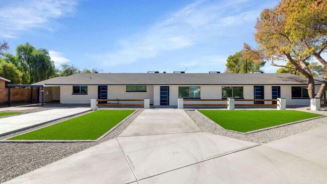
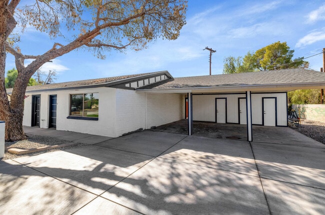
This Property Is For Sale
NEARBY LISTINGS FOR SALE OR LEASE
Property Detail
4821 E Sheridan St
Phoenix-Mesa-Chandler, AZ
Stafford Village 2
126-17-032
Maricopa
Triplex
Arizona
X
0.32 AC
04013C2230M
Papago
3,052 SF
Phoenix
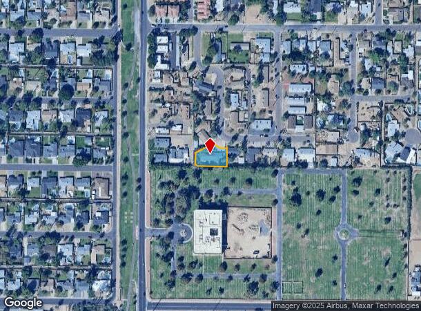
DEMOGRAPHICS near 4821 E Sheridan St
1 Mile
3 Mile
5 Mile
2024 Total Population
18,246
131,098
319,856
2029 Population
19,055
137,343
336,183
Pop Growth 2024-2029
+ 4.43%
+ 4.76%
+ 5.10%
Average Age
37
37
38
2024 Total Households
7,985
56,378
143,490
HH Growth 2024-2029
+ 4.60%
+ 4.94%
+ 5.37%
Median Household Inc
$70,204
$77,366
$78,910
Avg Household Size
2.20
2.30
2.10
2024 Avg HH Vehicles
2.00
2.00
2.00
Median Home Value
$644,832
$661,083
$625,374
Median Year Built
1975
1974
1977
Nearby Places
Map Layers
Map Styles
 Street
 Aerial
- Restaurants
- Banks
- Shops
- Fitness
- Groceries
PUBLIC TRANSPORTATION
AIRPORT
Phoenix Sky Harbor International
DRIVE
WALK
Distance
Phoenix Sky Harbor International
11 min
4.7 mi
Phoenix-Mesa Gateway
DRIVE
WALK
Distance
Phoenix-Mesa Gateway
44 min
30.0 mi
Nearby Properties
Address
Land Use
TOTAL SIZE
Lot Size
Zoning
Address
Land Use
TOTAL SIZE
Lot Size
Zoning
2,901,193 SF
20.73 AC
A-1
Address
Land Use
TOTAL SIZE
Lot Size
Zoning
75,000 SF
12.19 AC
I-1
Address
Land Use
TOTAL SIZE
Lot Size
Zoning
103,415 SF
4.61 AC
C-T
Address
Land Use
TOTAL SIZE
Lot Size
Zoning
111,886 SF
3.46 AC
C-G
Address
Land Use
TOTAL SIZE
Lot Size
Zoning
3.62 AC
Address
Land Use
TOTAL SIZE
Lot Size
Zoning
199,677 SF
14.55 AC
C-3
Address
Land Use
TOTAL SIZE
Lot Size
Zoning
1,457,213 SF
41.78 AC
PUD
Address
Land Use
TOTAL SIZE
Lot Size
Zoning
4.76 AC
C-G
Address
Land Use
TOTAL SIZE
Lot Size
Zoning
462,201 SF
6.74 AC
I-1
Address
Land Use
TOTAL SIZE
Lot Size
Zoning
697,894 SF
8.43 AC
PAD
Address
Land Use
TOTAL SIZE
Lot Size
Zoning
50,161 SF
2.05 AC
M-H
Address
Land Use
TOTAL SIZE
Lot Size
Zoning
3,010 SF
35.44 AC
R110
Address
Land Use
TOTAL SIZE
Lot Size
Zoning
76,801 SF
4.79 AC
R1-6
Address
Land Use
TOTAL SIZE
Lot Size
Zoning
9,344 SF
134.45 AC
R3
Address
Land Use
TOTAL SIZE
Lot Size
Zoning
688,550 SF
149.95 AC
R-6
Address
Land Use
TOTAL SIZE
Lot Size
Zoning
1,524,499 SF
159.88 AC
I-1
Address
Land Use
TOTAL SIZE
Lot Size
Zoning
285,883 SF
12.62 AC
I-1
Address
Land Use
TOTAL SIZE
Lot Size
Zoning
533,404 SF
18.79 AC
A1
Address
Land Use
TOTAL SIZE
Lot Size
Zoning
831,861 SF
4.25 AC
MU4
Address
Land Use
TOTAL SIZE
Lot Size
Zoning
344,504 SF
14.97 AC
WU
Address
Land Use
TOTAL SIZE
Lot Size
Zoning
303,171 SF
12.52 AC
I-1
Address
Land Use
TOTAL SIZE
Lot Size
Zoning
252,306 SF
112.57 AC
A-2
Address
Land Use
TOTAL SIZE
Lot Size
Zoning
62,497 SF
130.73 AC
R-6
Address
Land Use
TOTAL SIZE
Lot Size
Zoning
29,100 SF
1.42 AC
M-H
Address
Land Use
TOTAL SIZE
Lot Size
Zoning
282,287 SF
38.68 AC
R-10
Address
Land Use
TOTAL SIZE
Lot Size
Zoning
234,200 SF
8.38 AC
I-1
Address
Land Use
TOTAL SIZE
Lot Size
Zoning
Address
Land Use
TOTAL SIZE
Lot Size
Zoning
438,373 SF
11.35 AC
Address
Land Use
TOTAL SIZE
Lot Size
Zoning
153,890 SF
8.54 AC
C-R
Address
Land Use
TOTAL SIZE
Lot Size
Zoning
514,973 SF
4.14 AC
DDMU2
The World's #1 Commercial Real Estate Marketplace
Connect with us
© 2026 CoStar Group
The information above has been obtained from sources believed reliable. While we do not doubt its accuracy we have not verified it and make no guarantee, warranty or representation about it. It is your responsibility to independently confirm its accuracy and completeness. Any projections, opinions, assumptions, or estimates used are for example only and do not represent the current or future performance of the property. The value of this transaction to you depends on tax and other factors which should be evaluated by your tax, financial, and legal advisors. You and your advisors should conduct a careful, independent investigation of the property to determine to your satisfaction the suitability of the property for your needs.