Property Record
4822 George Washington Mem Hwy, Yorktown, VA 23692
NEARBY LISTINGS FOR SALE OR LEASE
Property Detail
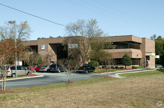
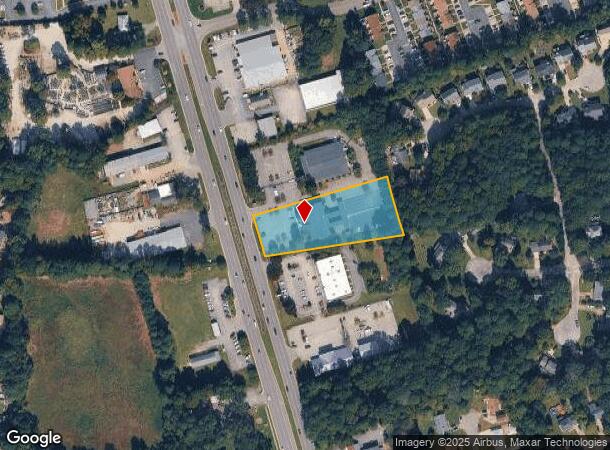
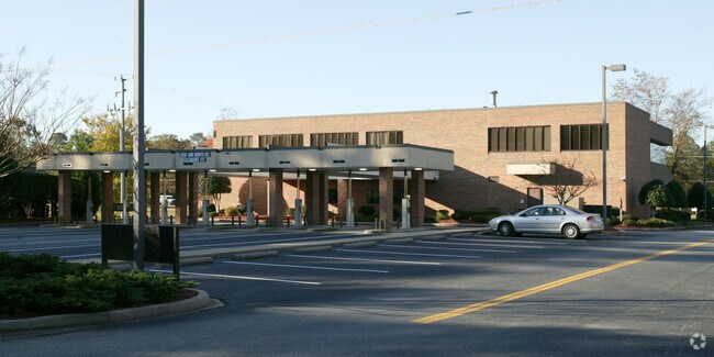
4822 George Washington Mem Hwy
Virginia Beach-Norfolk-Newport News, VA-NC
Langley Federal Credit Union Subdiv
S06C-2472-0495
LANGLEY FEDERAL CREDIT UNION SUBDIV OF LOT 1 LOT 1-B
Financialbuilding
York
X
Virginia
51199C0139D
1
2024
1.61 AC
2025
York
050303
Hampton Roads
13,956 SF
DEMOGRAPHICS near 4822 George Washington Mem Hwy
1 Mile
3 Mile
5 Mile
2024 Total Population
5,518
32,766
131,395
2029 Population
5,790
33,774
132,906
Pop Growth 2024-2029
+ 4.93%
+ 3.08%
+ 1.15%
Average Age
41
42
39
2024 Total Households
2,228
12,829
52,669
HH Growth 2024-2029
+ 4.94%
+ 2.92%
+ 0.92%
Median Household Inc
$88,281
$99,097
$78,314
Avg Household Size
2.50
2.50
2.40
2024 Avg HH Vehicles
2.00
2.00
2.00
Median Home Value
$343,704
$350,066
$302,989
Median Year Built
1986
1989
1986
Nearby Places
Map Layers
Map Styles
 Street
 Aerial
- Restaurants
- Banks
- Shops
- Fitness
- Groceries
PUBLIC TRANSPORTATION
AIRPORT
Newport News/Williamsburg International
DRIVE
WALK
Distance
Newport News/Williamsburg International
13 min
6.1 mi
Norfolk International
DRIVE
WALK
Distance
Norfolk International
44 min
28.4 mi
Freight Ports
Virginia Port Authority - Newport News
DRIVE
WALK
Distance
Virginia Port Authority - Newport News
25 min
16.3 mi
Nearby Properties
Address
Land Use
TOTAL SIZE
Lot Size
Zoning
Address
Land Use
TOTAL SIZE
Lot Size
Zoning
75,168 SF
824.63 AC
M1
Address
Land Use
TOTAL SIZE
Lot Size
Zoning
139,155 SF
15.01 AC
O2
Address
Land Use
TOTAL SIZE
Lot Size
Zoning
39,492 SF
798.51 AC
RESOURCE C
Address
Land Use
TOTAL SIZE
Lot Size
Zoning
297,617 SF
50.90 AC
RC,GB
Address
Land Use
TOTAL SIZE
Lot Size
Zoning
197,355 SF
10.89 AC
R8
Address
Land Use
TOTAL SIZE
Lot Size
Zoning
252 SF
17.21 AC
MULTI-FAMI
Address
Land Use
TOTAL SIZE
Lot Size
Zoning
5.04 AC
R9
Address
Land Use
TOTAL SIZE
Lot Size
Zoning
97,180 SF
53.17 AC
C1
Address
Land Use
TOTAL SIZE
Lot Size
Zoning
156 SF
19.99 AC
MULTI-FAMI
Address
Land Use
TOTAL SIZE
Lot Size
Zoning
96,438 SF
15 AC
P1
Address
Land Use
TOTAL SIZE
Lot Size
Zoning
201,289 SF
28.82 AC
GB,R20
Address
Land Use
TOTAL SIZE
Lot Size
Zoning
10,000 SF
9.10 AC
PLANNED DE
Address
Land Use
TOTAL SIZE
Lot Size
Zoning
56,654 SF
12.03 AC
LIMITED IN
Address
Land Use
TOTAL SIZE
Lot Size
Zoning
159,125 SF
30 AC
RESOURCE C
Address
Land Use
TOTAL SIZE
Lot Size
Zoning
37,012 SF
53.12 AC
LIMITED IN
Address
Land Use
TOTAL SIZE
Lot Size
Zoning
87,160 SF
19.68 AC
RESOURCE C
Address
Land Use
TOTAL SIZE
Lot Size
Zoning
80,784 SF
0.80 AC
O2
Address
Land Use
TOTAL SIZE
Lot Size
Zoning
7,275 SF
18.02 AC
IL,GB
Address
Land Use
TOTAL SIZE
Lot Size
Zoning
102,942 SF
7.34 AC
R8
Address
Land Use
TOTAL SIZE
Lot Size
Zoning
97,934 SF
26.70 AC
RESOURCE C
Address
Land Use
TOTAL SIZE
Lot Size
Zoning
930.01 AC
RESOURCE C
Address
Land Use
TOTAL SIZE
Lot Size
Zoning
59,550 SF
6.40 AC
HIGH DENSI
Address
Land Use
TOTAL SIZE
Lot Size
Zoning
48,272 SF
5 AC
GENERAL BU
Address
Land Use
TOTAL SIZE
Lot Size
Zoning
19,763 SF
2.98 AC
GENERAL BU
Address
Land Use
TOTAL SIZE
Lot Size
Zoning
255 SF
76.13 AC
M1
Address
Land Use
TOTAL SIZE
Lot Size
Zoning
188,367 SF
17.37 AC
GENERAL BU
Address
Land Use
TOTAL SIZE
Lot Size
Zoning
71,618 SF
7.42 AC
RURAL RESI
Address
Land Use
TOTAL SIZE
Lot Size
Zoning
68,151 SF
15.72 AC
RESOURCE C
Address
Land Use
TOTAL SIZE
Lot Size
Zoning
73,573 SF
2.81 AC
C1
Address
Land Use
TOTAL SIZE
Lot Size
Zoning
44,605 SF
12 AC
R8
The World's #1 Commercial Real Estate Marketplace
Connect with us
© 2025 CoStar Group
The information above has been obtained from sources believed reliable. While we do not doubt its accuracy we have not verified it and make no guarantee, warranty or representation about it. It is your responsibility to independently confirm its accuracy and completeness. Any projections, opinions, assumptions, or estimates used are for example only and do not represent the current or future performance of the property. The value of this transaction to you depends on tax and other factors which should be evaluated by your tax, financial, and legal advisors. You and your advisors should conduct a careful, independent investigation of the property to determine to your satisfaction the suitability of the property for your needs.