Property Record
4825 E Riverside Dr, Austin, TX 78741
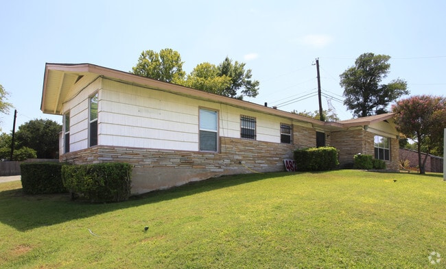


Property Detail
4825 E Riverside Dr
Austin-Round Rock-San Marcos, TX
LOT 1 KASPAREK ADDN
551508
Travis
Officebuilding
Texas
B and X Area of moderate flood hazard, usually the area between the limits of the 100-year and 500-year floods.
1
2025
0.33 AC
2025
Southeast
002314
Austin
2,331 SF
NEARBY LISTINGS FOR SALE OR LEASE
DEMOGRAPHICS near 4825 E Riverside Dr
1 mile
3 mile
5 mile
2025 Total Population
31,654
129,358
324,755
2030 Population
33,238
137,236
342,813
Pop Growth 2025-2030
+ 5.00%
+ 6.09%
+ 5.56%
Average Age
31
35
35
2025 Total Households
15,557
59,492
145,545
HH Growth 2025-2030
+ 5.70%
+ 6.82%
+ 6.39%
Median Household Inc
$61,310
$85,074
$85,147
Avg Household Size
2.00
2.00
2.00
2025 Avg HH Vehicles
1.00
1.00
2.00
Median Home Value
$402,031
$634,660
$666,493
Median Year Built
1996
2002
2000
Nearby Places
Map Layers
Map Styles
 Street
 Aerial
Layers
 Traffic
 Biking
Places
Listings with unknown addresses are not visible on the map
- Restaurants
- Banks
- Shops
- Fitness
- Groceries
PUBLIC TRANSPORTATION
COMMUTER RAIL
Austin (Texas Eagle - Amtrak)
Drive
Walk
Distance
Austin (Texas Eagle - Amtrak)
10 min
4.2 mi
AIRPORT
Austin-Bergstrom International
Drive
Walk
Distance
Austin-Bergstrom International
18 min
8.1 mi
Freight Ports
Calhoun Port
Drive
Walk
Distance
Calhoun Port
183 min
151.6 mi
Nearby Properties
Address
Land Use
TOTAL SIZE
Lot Size
Zoning
Address
Land Use
TOTAL SIZE
Lot Size
Zoning
9,768 SF
386.80 AC
Address
Land Use
TOTAL SIZE
Lot Size
Zoning
20,550 SF
14.15 AC
Address
Land Use
TOTAL SIZE
Lot Size
Zoning
1,156,135 SF
1.74 AC
Address
Land Use
TOTAL SIZE
Lot Size
Zoning
1,003,475 SF
1.84 AC
Address
Land Use
TOTAL SIZE
Lot Size
Zoning
9,034 SF
28.69 AC
Address
Land Use
TOTAL SIZE
Lot Size
Zoning
498,684 SF
61.86 AC
Address
Land Use
TOTAL SIZE
Lot Size
Zoning
47.20 AC
Address
Land Use
TOTAL SIZE
Lot Size
Zoning
1,400,000 SF
3.07 AC
Address
Land Use
TOTAL SIZE
Lot Size
Zoning
999,200 SF
25 AC
Address
Land Use
TOTAL SIZE
Lot Size
Zoning
609,613 SF
1.31 AC
Address
Land Use
TOTAL SIZE
Lot Size
Zoning
24.06 AC
Address
Land Use
TOTAL SIZE
Lot Size
Zoning
341,096 SF
0.31 AC
Address
Land Use
TOTAL SIZE
Lot Size
Zoning
546,000 SF
1.27 AC
Address
Land Use
TOTAL SIZE
Lot Size
Zoning
533,917 SF
0.81 AC
Address
Land Use
TOTAL SIZE
Lot Size
Zoning
400,000 SF
0.27 AC
Address
Land Use
TOTAL SIZE
Lot Size
Zoning
6.12 AC
Address
Land Use
TOTAL SIZE
Lot Size
Zoning
832,892 SF
30.12 AC
Address
Land Use
TOTAL SIZE
Lot Size
Zoning
27.45 AC
Address
Land Use
TOTAL SIZE
Lot Size
Zoning
357,080 SF
0.41 AC
Address
Land Use
TOTAL SIZE
Lot Size
Zoning
347,587 SF
0.41 AC
Address
Land Use
TOTAL SIZE
Lot Size
Zoning
397,281 SF
0.93 AC
Address
Land Use
TOTAL SIZE
Lot Size
Zoning
436,855 SF
1.61 AC
Address
Land Use
TOTAL SIZE
Lot Size
Zoning
652,852 SF
1.01 AC
Address
Land Use
TOTAL SIZE
Lot Size
Zoning
8,213 SF
36.95 AC
Address
Land Use
TOTAL SIZE
Lot Size
Zoning
372,000 SF
1.35 AC
Address
Land Use
TOTAL SIZE
Lot Size
Zoning
237,066 SF
2.19 AC
Address
Land Use
TOTAL SIZE
Lot Size
Zoning
8.17 AC
Address
Land Use
TOTAL SIZE
Lot Size
Zoning
250,514 SF
1.80 AC
Address
Land Use
TOTAL SIZE
Lot Size
Zoning
433,044 SF
2.58 AC
Address
Land Use
TOTAL SIZE
Lot Size
Zoning
356,147 SF
10.48 AC
The World's #1 Commercial Real Estate Marketplace
Connect with us
© 2026 CoStar Group
The information above has been obtained from sources believed reliable. While we do not doubt its accuracy we have not verified it and make no guarantee, warranty or representation about it. It is your responsibility to independently confirm its accuracy and completeness. Any projections, opinions, assumptions, or estimates used are for example only and do not represent the current or future performance of the property. The value of this transaction to you depends on tax and other factors which should be evaluated by your tax, financial, and legal advisors. You and your advisors should conduct a careful, independent investigation of the property to determine to your satisfaction the suitability of the property for your needs.