Property Record
4826 Airport Rd, Zephyrhills, FL 33542
NEARBY LISTINGS FOR SALE OR LEASE
-
-
View all Zephyrhills listings for lease on LoopNet.com
Property Detail
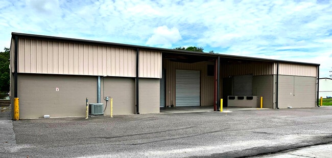
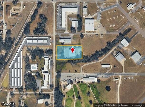
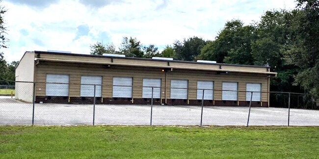
4826 Airport Rd
Tampa-St. Petersburg-Clearwater, FL
Acreage
13-26-21-0000-00100-0022
COM NW COR SECTION 13 TH N89DG 54 37E 1339.57 FT TH S00DG 07 19W 30.00 FT TH N89DG 54 37E 30.00 FT TH S00DG 07 19W 615.00 FT FOR POB TH N89DG 54 37E 370.00 FT TH S00DG 07 19W 189.68 FT TH S88DG 13 58W 370.20 FT TH N00DG 07 19E 200.52 FT TO POB
Warehouse
Pasco
AE
Florida
12101C0456F
22
2024
1.66 AC
2025
Pasco County
033101
Tampa/St Petersburg
8,180 SF
DEMOGRAPHICS near 4826 Airport Rd
1 Mile
3 Mile
5 Mile
2024 Total Population
5,675
42,400
66,961
2029 Population
6,833
51,681
81,386
Pop Growth 2024-2029
+ 20.41%
+ 21.89%
+ 21.54%
Average Age
44
51
50
2024 Total Households
2,498
20,147
30,646
HH Growth 2024-2029
+ 20.46%
+ 21.95%
+ 21.65%
Median Household Inc
$42,237
$40,577
$43,211
Avg Household Size
2.20
2.00
2.10
2024 Avg HH Vehicles
2.00
1.00
2.00
Median Home Value
$94,225
$98,565
$112,012
Median Year Built
1978
1984
1987
Nearby Places
Map Layers
Map Styles
 Street
 Aerial
- Restaurants
- Banks
- Shops
- Fitness
- Groceries
PUBLIC TRANSPORTATION
AIRPORT
Tampa International
DRIVE
WALK
Distance
Tampa International
54 min
36.7 mi
Freight Ports
Port of Tampa Bay
DRIVE
WALK
Distance
Port of Tampa Bay
47 min
30.2 mi
SALE & LEASE HISTORY
LISTING DATE
SALE/LEASE

Aug 18, 2020
For Lease
Nearby Properties
Address
Land Use
TOTAL SIZE
Lot Size
Zoning
Address
Land Use
TOTAL SIZE
Lot Size
Zoning
352,321 SF
27.88 AC
OP
Address
Land Use
TOTAL SIZE
Lot Size
Zoning
610,631 SF
45.79 AC
LI
Address
Land Use
TOTAL SIZE
Lot Size
Zoning
199,367 SF
15.46 AC
R2
Address
Land Use
TOTAL SIZE
Lot Size
Zoning
162,278 SF
118.82 AC
AP2
Address
Land Use
TOTAL SIZE
Lot Size
Zoning
292,589 SF
52.57 AC
R3
Address
Land Use
TOTAL SIZE
Lot Size
Zoning
91,192 SF
3.40 AC
C2
Address
Land Use
TOTAL SIZE
Lot Size
Zoning
41,812 SF
255.72 AC
AP2
Address
Land Use
TOTAL SIZE
Lot Size
Zoning
68,446 SF
3.54 AC
C2
Address
Land Use
TOTAL SIZE
Lot Size
Zoning
105,449 SF
5.14 AC
OP
Address
Land Use
TOTAL SIZE
Lot Size
Zoning
101.06 AC
MPUD
Address
Land Use
TOTAL SIZE
Lot Size
Zoning
60,759 SF
7.56 AC
C2
Address
Land Use
TOTAL SIZE
Lot Size
Zoning
32,076 SF
3.58 AC
PUD
Address
Land Use
TOTAL SIZE
Lot Size
Zoning
107,022 SF
13.27 AC
C2
Address
Land Use
TOTAL SIZE
Lot Size
Zoning
56,312 SF
8.85 AC
PUD
Address
Land Use
TOTAL SIZE
Lot Size
Zoning
94,412 SF
9.67 AC
C2
Address
Land Use
TOTAL SIZE
Lot Size
Zoning
76,015 SF
9.18 AC
C2
Address
Land Use
TOTAL SIZE
Lot Size
Zoning
143,626 SF
11.13 AC
R4
Address
Land Use
TOTAL SIZE
Lot Size
Zoning
61,636 SF
6.84 AC
C2
Address
Land Use
TOTAL SIZE
Lot Size
Zoning
131,274 SF
13.07 AC
R4
Address
Land Use
TOTAL SIZE
Lot Size
Zoning
27 AC
AC
Address
Land Use
TOTAL SIZE
Lot Size
Zoning
72,183 SF
42.44 AC
R3
Address
Land Use
TOTAL SIZE
Lot Size
Zoning
67,222 SF
7.96 AC
C2
Address
Land Use
TOTAL SIZE
Lot Size
Zoning
58,090 SF
5.30 AC
MF1
Address
Land Use
TOTAL SIZE
Lot Size
Zoning
28,549 SF
1.49 AC
SD
Address
Land Use
TOTAL SIZE
Lot Size
Zoning
20,543 SF
4.18 AC
C2
Address
Land Use
TOTAL SIZE
Lot Size
Zoning
89,820 SF
6.96 AC
C2
Address
Land Use
TOTAL SIZE
Lot Size
Zoning
48,607 SF
8.50 AC
R4
Address
Land Use
TOTAL SIZE
Lot Size
Zoning
63,200 SF
29.69 AC
C2
Address
Land Use
TOTAL SIZE
Lot Size
Zoning
58,184 SF
3.93 AC
C2
Address
Land Use
TOTAL SIZE
Lot Size
Zoning
14,928 SF
8.60 AC
C2
The World's #1 Commercial Real Estate Marketplace
Connect with us
© 2025 CoStar Group
The information above has been obtained from sources believed reliable. While we do not doubt its accuracy we have not verified it and make no guarantee, warranty or representation about it. It is your responsibility to independently confirm its accuracy and completeness. Any projections, opinions, assumptions, or estimates used are for example only and do not represent the current or future performance of the property. The value of this transaction to you depends on tax and other factors which should be evaluated by your tax, financial, and legal advisors. You and your advisors should conduct a careful, independent investigation of the property to determine to your satisfaction the suitability of the property for your needs.