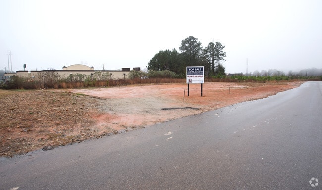
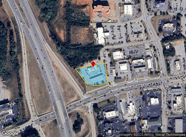
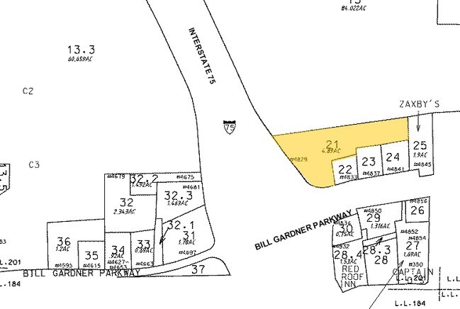
Property Record
4829 Bill Gardner Pky, Locust Grove, GA 30248
NEARBY LISTINGS FOR SALE OR LEASE
Property Detail
4829 Bill Gardner Pky
0112-01-021-000
LAND LOT: 201 /LAND DISTRICT: 2
Conveniencestore
Henry
X
Georgia
13255C0125E
201
2025
1.71 AC
2025
South Clayton/Henry Cnty
070411
Atlanta
5,691 SF
Atlanta-Sandy Springs-Roswell, GA
DEMOGRAPHICS near 4829 Bill Gardner Pky
1 Mile
3 Mile
5 Mile
2024 Total Population
1,664
18,161
43,447
2029 Population
1,869
20,189
47,805
Pop Growth 2024-2029
+ 12.32%
+ 11.17%
+ 10.03%
Average Age
35
36
37
2024 Total Households
588
6,224
14,629
HH Growth 2024-2029
+ 12.41%
+ 11.31%
+ 10.12%
Median Household Inc
$62,525
$68,492
$73,673
Avg Household Size
2.80
2.90
2.90
2024 Avg HH Vehicles
2.00
2.00
2.00
Median Home Value
$161,111
$208,308
$226,509
Median Year Built
2007
2005
2003
Nearby Places
Map Layers
Map Styles
 Street
 Aerial
- Restaurants
- Banks
- Shops
- Fitness
- Groceries
PUBLIC TRANSPORTATION
AIRPORT
Hartsfield - Jackson Atlanta International
DRIVE
WALK
Distance
Hartsfield - Jackson Atlanta International
37 min
29.3 mi
Nearby Properties
Address
Land Use
TOTAL SIZE
Lot Size
Zoning
Address
Land Use
TOTAL SIZE
Lot Size
Zoning
1,012,028 SF
98.01 AC
M1
Address
Land Use
TOTAL SIZE
Lot Size
Zoning
1,079,756 SF
92.38 AC
M1
Address
Land Use
TOTAL SIZE
Lot Size
Zoning
1,010,600 SF
78.40 AC
M1
Address
Land Use
TOTAL SIZE
Lot Size
Zoning
4,307,236 SF
66.85 AC
M1
Address
Land Use
TOTAL SIZE
Lot Size
Zoning
765,316 SF
85.65 AC
M1
Address
Land Use
TOTAL SIZE
Lot Size
Zoning
22,633 SF
31 AC
RM
Address
Land Use
TOTAL SIZE
Lot Size
Zoning
4,982 SF
34.62 AC
RM
Address
Land Use
TOTAL SIZE
Lot Size
Zoning
660,000 SF
129.11 AC
M1
Address
Land Use
TOTAL SIZE
Lot Size
Zoning
351,848 SF
41.63 AC
C2
Address
Land Use
TOTAL SIZE
Lot Size
Zoning
297,736 SF
57.04 AC
M
Address
Land Use
TOTAL SIZE
Lot Size
Zoning
678,692 SF
47.81 AC
M1
Address
Land Use
TOTAL SIZE
Lot Size
Zoning
205,200 SF
16.25 AC
M1
Address
Land Use
TOTAL SIZE
Lot Size
Zoning
614,100 SF
22.72 AC
M1
Address
Land Use
TOTAL SIZE
Lot Size
Zoning
197,290 SF
22.14 AC
M1
Address
Land Use
TOTAL SIZE
Lot Size
Zoning
166,447 SF
66.49 AC
Address
Land Use
TOTAL SIZE
Lot Size
Zoning
405,620 SF
19.94 AC
M1
Address
Land Use
TOTAL SIZE
Lot Size
Zoning
155,331 SF
22.52 AC
C
Address
Land Use
TOTAL SIZE
Lot Size
Zoning
112,106 SF
13.08 AC
C1
Address
Land Use
TOTAL SIZE
Lot Size
Zoning
6,720 SF
1,081.34 AC
Address
Land Use
TOTAL SIZE
Lot Size
Zoning
101,196 SF
17.01 AC
RA
Address
Land Use
TOTAL SIZE
Lot Size
Zoning
213,520 SF
34.42 AC
Address
Land Use
TOTAL SIZE
Lot Size
Zoning
928 SF
94.14 AC
C3
Address
Land Use
TOTAL SIZE
Lot Size
Zoning
40,105 SF
4.33 AC
C3
Address
Land Use
TOTAL SIZE
Lot Size
Zoning
802,700 SF
7.07 AC
M1
Address
Land Use
TOTAL SIZE
Lot Size
Zoning
684,314 SF
76.70 AC
Address
Land Use
TOTAL SIZE
Lot Size
Zoning
44,267 SF
2 AC
C3
Address
Land Use
TOTAL SIZE
Lot Size
Zoning
65,436 SF
2.55 AC
Address
Land Use
TOTAL SIZE
Lot Size
Zoning
36,319 SF
1.54 AC
C3
The World's #1 Commercial Real Estate Marketplace
Connect with us
© 2026 CoStar Group
The information above has been obtained from sources believed reliable. While we do not doubt its accuracy we have not verified it and make no guarantee, warranty or representation about it. It is your responsibility to independently confirm its accuracy and completeness. Any projections, opinions, assumptions, or estimates used are for example only and do not represent the current or future performance of the property. The value of this transaction to you depends on tax and other factors which should be evaluated by your tax, financial, and legal advisors. You and your advisors should conduct a careful, independent investigation of the property to determine to your satisfaction the suitability of the property for your needs.