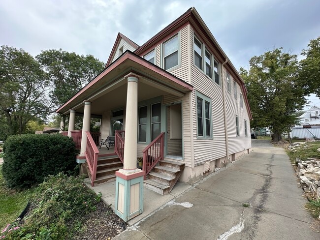
Property Record
4829 Calvert St, Lincoln, NE 68506

NEARBY LISTINGS FOR SALE OR LEASE
-
-
View all Lincoln listings for sale on LoopNet.com
Property Detail
4829 Calvert St
Lincoln, NE
College View
16-05-400-005-000
COLLEGE VIEW, BLOCK 3, LOT 5
Commercialnec
Lancaster
X
Nebraska
31109C0319F
5
2024
0.16 AC
2025
South Lincoln
002701
Lincoln
2,402 SF
DEMOGRAPHICS near 4829 Calvert St
1 Mile
3 Mile
5 Mile
2024 Total Population
13,710
110,976
223,688
2029 Population
14,063
114,511
231,990
Pop Growth 2024-2029
+ 2.57%
+ 3.19%
+ 3.71%
Average Age
41
41
38
2024 Total Households
6,160
48,023
93,381
HH Growth 2024-2029
+ 2.73%
+ 3.28%
+ 3.86%
Median Household Inc
$60,725
$67,991
$65,809
Avg Household Size
2.10
2.20
2.30
2024 Avg HH Vehicles
2.00
2.00
2.00
Median Home Value
$194,264
$243,742
$244,428
Median Year Built
1969
1973
1976
Nearby Places
Map Layers
Map Styles
 Street
 Aerial
- Restaurants
- Banks
- Shops
- Fitness
- Groceries
PUBLIC TRANSPORTATION
COMMUTER RAIL
DRIVE
WALK
Distance
11 min
4.9 mi
AIRPORT
Lincoln
DRIVE
WALK
Distance
Lincoln
18 min
10.5 mi
SALE & LEASE HISTORY
LISTING DATE
SALE/LEASE

Oct 13, 2023
For Sale
Nearby Properties
Address
Land Use
TOTAL SIZE
Lot Size
Zoning
Address
Land Use
TOTAL SIZE
Lot Size
Zoning
604,749 SF
20.55 AC
R2
Address
Land Use
TOTAL SIZE
Lot Size
Zoning
364,797 SF
25.06 AC
R1
Address
Land Use
TOTAL SIZE
Lot Size
Zoning
684,598 SF
21.16 AC
B3
Address
Land Use
TOTAL SIZE
Lot Size
Zoning
329,069 SF
30 AC
R6
Address
Land Use
TOTAL SIZE
Lot Size
Zoning
531,687 SF
32.18 AC
B5
Address
Land Use
TOTAL SIZE
Lot Size
Zoning
71,046 SF
23.72 AC
R5
Address
Land Use
TOTAL SIZE
Lot Size
Zoning
213,738 SF
14.97 AC
B5
Address
Land Use
TOTAL SIZE
Lot Size
Zoning
185,015 SF
38.72 AC
AGR
Address
Land Use
TOTAL SIZE
Lot Size
Zoning
17,070 SF
8.95 AC
R3
Address
Land Use
TOTAL SIZE
Lot Size
Zoning
37,240 SF
17.06 AC
NULL
Address
Land Use
TOTAL SIZE
Lot Size
Zoning
234,103 SF
13.56 AC
R2
Address
Land Use
TOTAL SIZE
Lot Size
Zoning
36,751 SF
1.80 AC
B5
Address
Land Use
TOTAL SIZE
Lot Size
Zoning
179,447 SF
7.85 AC
R6
Address
Land Use
TOTAL SIZE
Lot Size
Zoning
131,316 SF
26.31 AC
R3
Address
Land Use
TOTAL SIZE
Lot Size
Zoning
119,335 SF
26.11 AC
R1
Address
Land Use
TOTAL SIZE
Lot Size
Zoning
142,179 SF
9.68 AC
R3
Address
Land Use
TOTAL SIZE
Lot Size
Zoning
90,362 SF
2.53 AC
B3
Address
Land Use
TOTAL SIZE
Lot Size
Zoning
148,760 SF
4.99 AC
R4
Address
Land Use
TOTAL SIZE
Lot Size
Zoning
32,854 SF
22.09 AC
NULL
Address
Land Use
TOTAL SIZE
Lot Size
Zoning
192,751 SF
18.49 AC
B5
Address
Land Use
TOTAL SIZE
Lot Size
Zoning
32,443 SF
7.20 AC
NULL
Address
Land Use
TOTAL SIZE
Lot Size
Zoning
214,823 SF
19.37 AC
B5
Address
Land Use
TOTAL SIZE
Lot Size
Zoning
22,324 SF
16.59 AC
NULL
Address
Land Use
TOTAL SIZE
Lot Size
Zoning
68,664 SF
7 AC
NULL
Address
Land Use
TOTAL SIZE
Lot Size
Zoning
16,284 SF
8.77 AC
NULL
Address
Land Use
TOTAL SIZE
Lot Size
Zoning
39,968 SF
13.41 AC
NULL
Address
Land Use
TOTAL SIZE
Lot Size
Zoning
18,506 SF
12.61 AC
NULL
Address
Land Use
TOTAL SIZE
Lot Size
Zoning
17,184 SF
15.39 AC
NULL
Address
Land Use
TOTAL SIZE
Lot Size
Zoning
67,029 SF
17.26 AC
R3
Address
Land Use
TOTAL SIZE
Lot Size
Zoning
131,049 SF
78.38 AC
P
The World's #1 Commercial Real Estate Marketplace
Connect with us
© 2025 CoStar Group
The information above has been obtained from sources believed reliable. While we do not doubt its accuracy we have not verified it and make no guarantee, warranty or representation about it. It is your responsibility to independently confirm its accuracy and completeness. Any projections, opinions, assumptions, or estimates used are for example only and do not represent the current or future performance of the property. The value of this transaction to you depends on tax and other factors which should be evaluated by your tax, financial, and legal advisors. You and your advisors should conduct a careful, independent investigation of the property to determine to your satisfaction the suitability of the property for your needs.