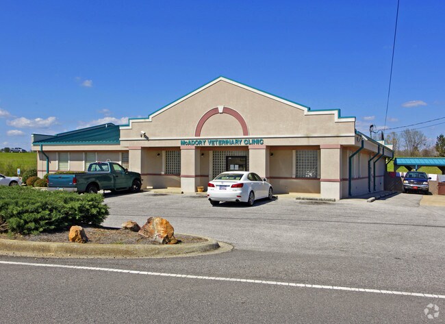
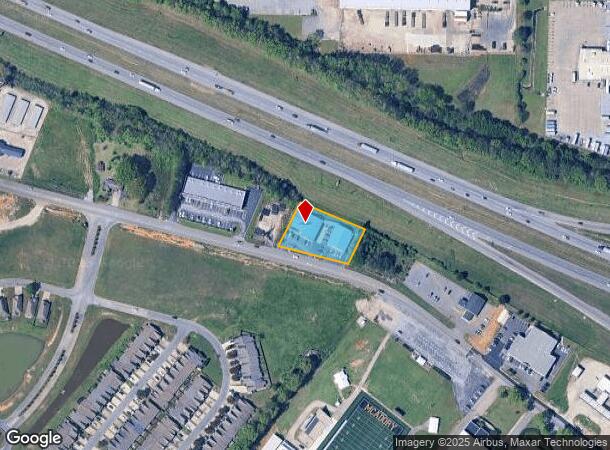
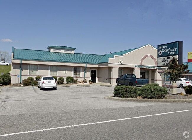
Property Record
4829 Mcadory School Rd, Mc Calla, AL 35111
NEARBY LISTINGS FOR SALE OR LEASE
Property Detail
4829 Mcadory School Rd
42-00-06-2-000-005.002
COM NW COR OF SW4 SEC 6 TP 20S R 4W TH E 480 FT SE ALG SW R/W OF I-459 220 FT TO POB CONT SE 229.3 FT SW 127.1 FT TO N R/W OF MCADORY SCHOOL RD TH NW ALG R/W233.8 FT TH NE 157.6 FT TO POB
Policefirecivildefense
Jefferson
X
Alabama
01125C0450G
0.80 AC
2023
Bessemer
2024
Birmingham
014207
Birmingham, AL
9,958 SF
DEMOGRAPHICS near 4829 Mcadory School Rd
1 Mile
3 Mile
5 Mile
2024 Total Population
3,209
14,589
31,979
2029 Population
3,081
14,176
31,252
Pop Growth 2024-2029
(3.99%)
(2.83%)
(2.27%)
Average Age
39
40
41
2024 Total Households
1,305
5,761
12,620
HH Growth 2024-2029
(4.14%)
(3.02%)
(2.42%)
Median Household Inc
$58,917
$63,570
$57,415
Avg Household Size
2.40
2.40
2.40
2024 Avg HH Vehicles
2.00
2.00
2.00
Median Home Value
$203,437
$212,467
$196,049
Median Year Built
2004
2000
1985
Nearby Places
Map Layers
Map Styles
 Street
 Aerial
- Restaurants
- Banks
- Shops
- Fitness
- Groceries
PUBLIC TRANSPORTATION
AIRPORT
Birmingham-Shuttlesworth International
DRIVE
WALK
Distance
Birmingham-Shuttlesworth International
33 min
27.0 mi
Nearby Properties
Address
Land Use
TOTAL SIZE
Lot Size
Zoning
Address
Land Use
TOTAL SIZE
Lot Size
Zoning
1,740 SF
21 AC
A1/I
Address
Land Use
TOTAL SIZE
Lot Size
Zoning
184,428 SF
9.70 AC
01
Address
Land Use
TOTAL SIZE
Lot Size
Zoning
657,600 SF
67.11 AC
I-4
Address
Land Use
TOTAL SIZE
Lot Size
Zoning
499,171 SF
20.23 AC
I4
Address
Land Use
TOTAL SIZE
Lot Size
Zoning
303,730 SF
22.20 AC
I4
Address
Land Use
TOTAL SIZE
Lot Size
Zoning
526,350 SF
24.62 AC
I2
Address
Land Use
TOTAL SIZE
Lot Size
Zoning
178,953 SF
30 AC
C4
Address
Land Use
TOTAL SIZE
Lot Size
Zoning
384,230 SF
19.91 AC
I4
Address
Land Use
TOTAL SIZE
Lot Size
Zoning
300,300 SF
13.33 AC
I4
Address
Land Use
TOTAL SIZE
Lot Size
Zoning
47,705 SF
0.69 AC
01
Address
Land Use
TOTAL SIZE
Lot Size
Zoning
152,940 SF
33.12 AC
I4
Address
Land Use
TOTAL SIZE
Lot Size
Zoning
240,240 SF
7.33 AC
I4
Address
Land Use
TOTAL SIZE
Lot Size
Zoning
293,440 SF
22.46 AC
I4
Address
Land Use
TOTAL SIZE
Lot Size
Zoning
111,983 SF
1.90 AC
I4/U
Address
Land Use
TOTAL SIZE
Lot Size
Zoning
125,937 SF
7 AC
C4
Address
Land Use
TOTAL SIZE
Lot Size
Zoning
200,227 SF
25.10 AC
C-4
Address
Land Use
TOTAL SIZE
Lot Size
Zoning
175,224 SF
9.70 AC
R2
Address
Land Use
TOTAL SIZE
Lot Size
Zoning
38,868 SF
10.90 AC
C-4
Address
Land Use
TOTAL SIZE
Lot Size
Zoning
30,177 SF
2.45 AC
I
Address
Land Use
TOTAL SIZE
Lot Size
Zoning
100,050 SF
14 AC
C-4
Address
Land Use
TOTAL SIZE
Lot Size
Zoning
122,720 SF
6.77 AC
O1-R
Address
Land Use
TOTAL SIZE
Lot Size
Zoning
132,683 SF
16 AC
R-4
Address
Land Use
TOTAL SIZE
Lot Size
Zoning
83,450 SF
4.20 AC
C4
Address
Land Use
TOTAL SIZE
Lot Size
Zoning
63.30 AC
I3
Address
Land Use
TOTAL SIZE
Lot Size
Zoning
43,423 SF
8.16 AC
A1
Address
Land Use
TOTAL SIZE
Lot Size
Zoning
51,952 SF
6.24 AC
A1
Address
Land Use
TOTAL SIZE
Lot Size
Zoning
2.50 AC
C4
Address
Land Use
TOTAL SIZE
Lot Size
Zoning
25,182 SF
1.76 AC
C4
Address
Land Use
TOTAL SIZE
Lot Size
Zoning
38,376 SF
4.87 AC
C3
Address
Land Use
TOTAL SIZE
Lot Size
Zoning
47,284 SF
11.30 AC
0-1/
The World's #1 Commercial Real Estate Marketplace
Connect with us
© 2026 CoStar Group
The information above has been obtained from sources believed reliable. While we do not doubt its accuracy we have not verified it and make no guarantee, warranty or representation about it. It is your responsibility to independently confirm its accuracy and completeness. Any projections, opinions, assumptions, or estimates used are for example only and do not represent the current or future performance of the property. The value of this transaction to you depends on tax and other factors which should be evaluated by your tax, financial, and legal advisors. You and your advisors should conduct a careful, independent investigation of the property to determine to your satisfaction the suitability of the property for your needs.